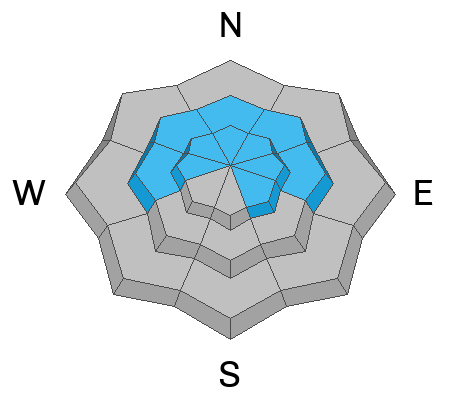
Forecast for the Salt Lake Area Mountains

Nikki Champion
Issued by Nikki Champion on
Wednesday morning, February 12, 2025
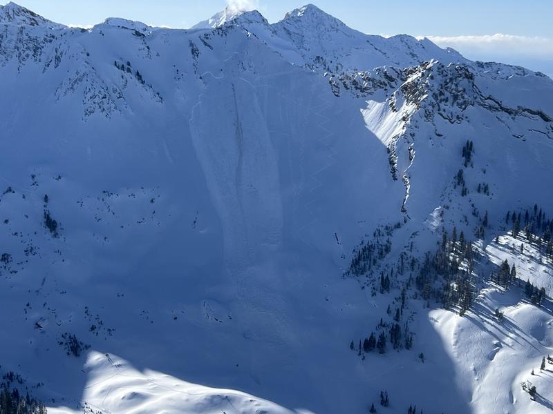
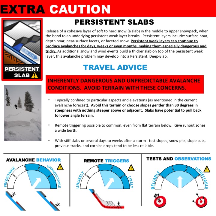
A MODERATE avalanche danger exists on mid and upper-elevation northwest to east-facing slopes. On these slopes, you may trigger avalanches up to 1–3 feet deep and several hundred feet wide, failing on a variety of weak layers in the snowpack. While natural avalanches are unlikely, human-triggered avalanches are possible and should not be taken lightly.
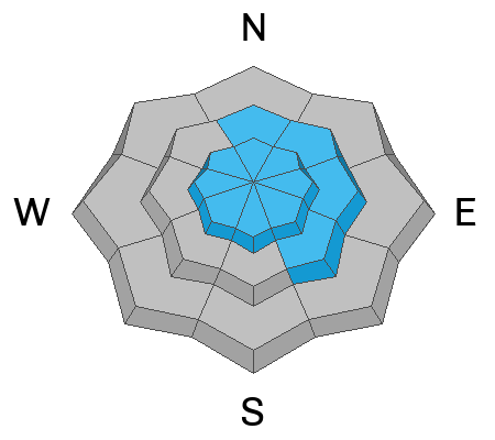
The MODERATE danger extends to many other steep slopes, where human-triggered avalanches remain possible due to both wind-drifted snow and lingering new snow. Avalanche terrain must be approached with strong caution, as unstable slabs may exist on specific terrain features. Conditions are complex, and stability is variable—pay attention and be prepared to adjust your plans if necessary.
Low
Moderate
Considerable
High
Extreme
Learn how to read the forecast here
Special Announcements
It’s been a tough few weeks for the backcountry community, with too many close calls and heartbreaking losses. Our thoughts are with everyone affected—this is a tight-knit group, and these tragedies hit hard.
As more details come in, accident reports will continue to be updated and published. If you have a moment, consider reading through one or more of them.
  • A preliminary report on Saturday’s avalanche fatality in the East Bowl of Silver Fork can be found [HERE].
  • The full report on the February 3rd avalanche fatality on Monte Cristo (Ogden Mountains) is published [HERE].
  • The accident report detailing the full and partial burial close call in Dutch Draw (Park City ridgeline) from Saturday is available [HERE].
Weather and Snow
This morning, temperatures are between -2°F and -10°F at trailheads and around -14°F on the highest ridgelines, not factoring in wind chill. Winds out of the west-northwest have been steady overnight, averaging 10–15 mph with gusts up to 25 mph at mid-elevations and 30–40 mph gusting to 50 mph at the highest ridgelines. Lake-enhanced snowfall continued overnight, with 1–3 inches of light, low-density snow in the Upper Cottonwoods.
Today, temperatures will rise to 8–15°F. Light snow showers may linger in the Upper Cottonwoods this afternoon before tapering off as drier air moves in. Winds will remain westerly to west-northwest through Wednesday, shifting to southwest early Thursday morning. Wind speeds will average 5–10 mph with gusts up to 20 mph at mid-elevations and 20–30 mph with gusts of 30–40 mph at the highest ridgelines.
The forecast calls for a long-duration storm with significant snowfall, bringing 26–44 inches between February 13th and 16th. Snow will begin in the Wasatch by Thursday afternoon and continue through Saturday, with the heaviest snowfall expected late Thursday into Friday morning as a system adds instability.

I’m keeping a quote from Drew’s forecast yesterday because it sums up what many of us are feeling:
"It's some of the best skiing and riding of the year right now, but we don't sit easy in the forecast office. I view the snowpack structure as fairly complex with a lot of avalanches failing on a lot of different weak layers. Some of the weak layers formed in November and December, some in late January, some with Friday's blockbuster storm. When the snowpack gets complex, I recommend choosing the simple option: low-angle terrain. There's plenty of slopes 30° or less that offer excellent riding without having to thread the needle or outsmart the avalanches. Just my 2 cents from 25 years in the easy chair."
Recent Avalanches
No new avalanches were reported in the backcountry on Tuesday, but Monday saw two large, unintentionally triggered slides—both close calls involving experienced skiers.
  • The first avalanche occurred on a steep, northeast-facing slope at 10,400' on Cardiac Ridge (photo courtesy of Powderbird). It broke 2–3' deep and over 200' wide, leaving a large debris pile and some initial uncertainty about a possible burial. Fortunately, the skier managed to ski off the slab at the top and was not caught.
  • The second avalanche happened in the north bowl of Lake Peak in mid-White Pine, Little Cottonwood Canyon. A solo skier on the uptrack remotely triggered a 2.5'-deep, 300'-wide slide that broke 300' above him. He was caught and carried 500' but was able to dust himself off and ski away. This slope, at 10,400' on a north aspect, already had five prior tracks.
Both avalanches failed on old faceted snow on slopes that had previously avalanched during the Christmas cycle.
As winds and a bit of snowfall ramped up yesterday afternoon, ski resorts reported sensitive wind slabs forming at upper and mid-elevations.
Ad
Avalanche Problem #1
Persistent Weak Layer
Type
Location
Likelihood
Size
Description
Two buried weak layers of faceted snow in the snowpack continue to be triggered by skiers and riders—this is not speculation. The evidence is clear, check the avalanches tab for the recent examples from Monday and this past weekend.
  • The upper weak layer is buried around 1–2 feet deep, formed during the cold weather at the end of January.
  • The lower layer, near the ground, formed in November/December and has caused many large avalanches. This layer is most likely to be triggered in steep, thin snowpack areas, and repeater slopes—places that have previously avalanched. This layer continues to avalanche, continues to reload, and continues to be an issue. Avalanches up to 1–3+ feet deep remain possible.
These weak layers are primarily found on north-facing slopes, with some east and west-facing pockets at mid and upper elevations. These are tricky, dangerous layers that demand extra caution. Significant spatial variability exists—snow pits may not reflect conditions on similar aspects and elevations.
The graphics below illustrate the complex nature of persistent weak layer issues in the snowpack
Avalanche Problem #2
Wind Drifted Snow
Type
Location
Likelihood
Size
Description
With the overnight increase in winds and soft snow available for transport, you may trigger shallow hard or soft slabs of wind-drifted snow today, especially on steep north, east, and south-facing slopes. These slabs may be more sensitive as they rest on loose grains from Sunday, and some could be triggered from a distance.
Watch for pillow-shaped deposits and avoid them. Signs of instability—shooting cracks, collapsing, and overhanging cornices—indicate unstable terrain.
Outside the wind zone, especially on shaded slopes, new snow could still be sensitive in steep terrain. These interfaces are slowly stabilizing, but soft slabs are still possible on many aspects and elevations.
General Announcements
This information does not apply to developed ski areas or highways where avalanche control is normally done. This forecast is from the U.S.D.A. Forest Service, which is solely responsible for its content. This forecast describes general avalanche conditions and local variations always occur.