UDOT PLANNED AVALANCHE CLOSURES!!

Forecast for the Provo Area Mountains

Trent Meisenheimer
Issued by Trent Meisenheimer on
Saturday morning, January 11, 2025
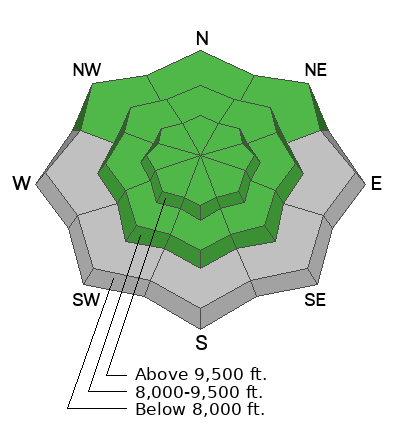
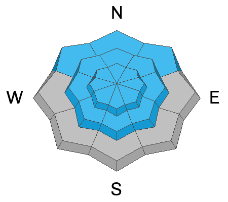
The avalanche danger is CONSIDERABLE on upper-elevation slopes and MODERATE on mid-elevation slopes facing northwest through east where there is a buried persistent weak layer. Avalanches may be 2-4 feet deep and over a hundred feet wide. We also have a CONSIDERABLE avalanche danger across all upper elevations for wind-drifted snow avalanches. Sensitive slabs of wind-drifted snow may be found on all aspects at the mid and upper elevations.
Low
Moderate
Considerable
High
Extreme
Learn how to read the forecast here
Special Announcements
Receive forecast region-specific text message alerts to receive messages about changing avalanche conditions, watches, and warnings. Sign up and update your preferences HERE.
Weather and Snow
It's trying to snow. Overnight snow totals are 1 to 4 inches of new snow with 0.01 to 0.20 inches of water. The wind has picked up from the west-northwest blowing 20-25 mph with gusts into the 20s and 30s across the upper elevations. Temperatures are cold and range from 5-20 °F.
Today, we should see snowfall into the early morning hours, and if the flow stays northwest, we could see 2-4 inches of snow throughout the day. Fingers crossed. The wind will stay elevated for the morning and slowly decrease throughout the day. Temperatures will remain cold and top out in the low to mid-20s °F today.
Recent Avalanches
No avalanches were reported from the backcountry. Click the button below to see recent observations and avalanches.
Ad
Avalanche Problem #1
Wind Drifted Snow
Type
Location
Likelihood
Size
Description
Strong northwest winds are blowing at speeds of 25-30 mph, with gusts into the 30s this morning. The wind also blows across the mid-elevations, with gusts into the 20s and 30s at 8,000'. This wind will indeed create new shallow soft slabs of wind-drifted snow. The unfortunate news is we've seen wind over the past 48 hours from all directions and both shallow soft or old hard stiff wind slabs could be found.
If the snow is pillowy or rounded, you've likely found a new drift of wind-blown snow. If the snow is hard and hollow-sounding, you likely found a hard drift of wind-blown snow. I would expect wind-drifted snow on all aspects and elevations today.
These drifts may break into the old snow surface, as many observers noted the old snow surface becoming loose and faceted from the past few days of clear and cold weather. Any wind-drifted snow avalanche can also step down to deeper, weaker layers on terrain facing west to north to east at the mid and upper elevations (see PWL below).
Avalanche Problem #2
Persistent Weak Layer
Type
Location
Likelihood
Size
Description
The persistent weak layer (PWL) slowly continues to gain strength, and it is getting more difficult to trigger avalanches. The type of terrain you are more likely to trigger an avalanche failing on the PWL is thinner snowpack areas such as:
  • Mid-elevations (particularly between 8,000 - 9,000') where there is less snow.
  • Steep, rocky areas.
  • Slopes that have already avalanched (aka "repeater" slopes) and have partially filled in.
If you trigger an avalanche in one of these thinner snowpack areas, it could propagate widely and up to 4 feet deep.
General Announcements
This information does not apply to developed ski areas or highways where avalanche control is normally done. This forecast is from the U.S.D.A. Forest Service, which is solely responsible for its content. This forecast describes general avalanche conditions and local variations always occur.