Forecast for the Salt Lake Area Mountains

Drew Hardesty
Issued by Drew Hardesty on
Tuesday morning, February 11, 2025
Areas* of CONSIDERABLE avalanche danger exist on mid and upper elevation northwest to east facing terrain. On these slopes, you may trigger soft slab avalanches 1-3 feet thick and a couple hundred feet wide failing on a variety of weak interfaces. A MODERATE danger exists on many other steep slopes where human triggered avalanches remain possible.
Strict travel protocols are essential for backcountry riding today.
Low
Moderate
Considerable
High
Extreme
Learn how to read the forecast here
Special Announcements

Insight into yesterday. I'm at the hospital talking with the survivor of Saturday's fatal avalanche accident in Silver Fork. The victim had been an acquaintance of mine. It's Utah's fourth fatality of the winter. The survivor is recovering from surgery to repair his broken leg. It's midday. And then my phone blows up with reports of a large avalanche triggered along the Cardiac Ridge with potential multiple burials...

A very preliminary report for the avalanche fatality in the East Bowl of Silverfork from Saturday can be found HERE>

The accident report for the avalanche fatality on Monte Cristo (Ogden mountains) from February 3rd is published HERE.
The accident report for the full burial and partial burial (live recoveries) in Dutch Draw (Park City ridgeline) from Saturday is published HERE.

Please join UAC Forecaster Craig Gordon at Ecker Hill Middle School tonight from 6:30-8:00 PM for a State of the Snowpack presentation hosted by Park City Professional Ski Patrol Association -- Reserve a spot HERE.
Weather and Snow


I thought I'd shake it up a bit.
These two avalanches above were unintentionally triggered yesterday by two long time and very experienced backcountry skiers. Both very close calls.
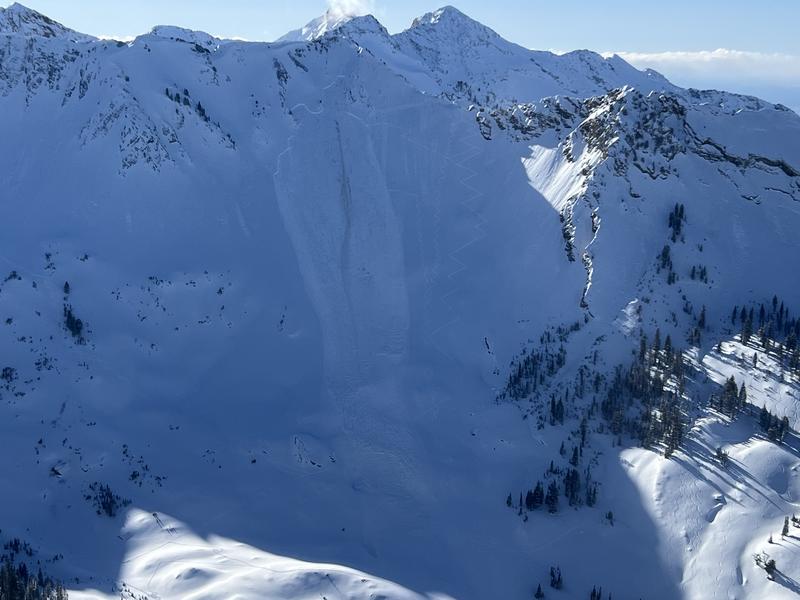
The top photo (courtesy Powderbird) is on the Cardiac Ridge on a steep northeast facing slope at 10,400'. It broke 2-3' deep and over 200' wide. It left a large debris pile and led to some confusion as to whether anyone was buried. The skier was not caught as he skiied off the slab at the top.
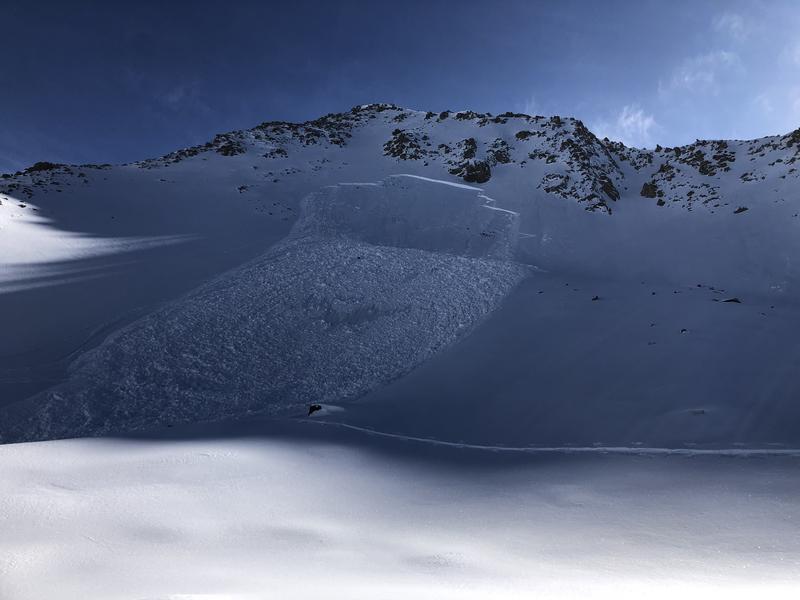
The bottom photo is in the north bowl of Lake Peak in mid-White Pine of Little Cottonwood Canyon. A solo skier on the uptrack remotely triggered a sizeable avalanche 2.5' deep and 300' wide. It broke 300' above him. He was caught and carried 500', dusted himself off and skiied away. 10,400' north facing. There were five previous tracks on the slope.
Both of these avalanches broke on old faceted snow on slopes that avalanched previously over the Christmas cycle.


It's some of the best skiing and riding of the year right now, but we don't sit easy in the forecast office. I view the snowpack structure as fairly complex with a lot of avalanches failing on a lot of different weak layers. Some of the weak layers formed in November and December, some in late January, some with Friday's blockbuster storm. When the snowpack gets complex, I recommend choosing the simple option: low angle terrain. There's plenty of slopes 30° or less that offer excellent riding without having to thread the needle or outsmart the avalanches. Just my 2 cents from 25 years in the easy chair.


Skies are mostly cloudy ahead of a weak brush-by storm that'll offer an inch or three, but mainly it'll drop temps to five below zero Fahrenheit by tomorrow. Winds should be light from the west. By Thursday, temperatures will rebound and winds will become strong from the southwest ahead of a potent looking storm for Thursday night through Saturday.
Recent Avalanches
See above. Also, ski area control teams triggered some hard slabs of wind drifted snow in the high alpine of LCC.
Ad
Avalanche Problem #1
Persistent Weak Layer
Type
Location
Likelihood
Size
Description
There are two buried weak layers of faceted snow in our snowpack that continue to be triggered by skiers and riders in the backcountry. This is not speculation. Exhibit A and B are above. Click on the avalanches tab for more evidence.
One is roughly 12-24 inches down and was buried at the end of January. The other is our old November/December weak layer that produced avalanches over the holidays and have been reloaded, waiting to be triggered again. These weak layers are primarily on the north side of the compass with a little east and west thrown in here and there at the mid and upper elevations. I view these as tricky and dangerous, warranting extra caution.
CAUTION: There is a wide array of spatial variability out there - snow pits may not be representative of similar aspects and elevations.
Avalanche Problem #2
New Snow
Type
Location
Likelihood
Size
Description
Friday's blockbuster of a storm resulted in a number of natural and human triggered avalanches on a variety of aspects and elevations. These interfaces are slowly healing but you may still be able to trigger a soft slab today on many aspects and elevations. Pay close attention to cracking and collapsing. I am particularly suspicious of aspects with an easterly component that may involve crusts. The avalanche in the Meadow Chutes of Silver Fork from Saturday comes to mind.
Avalanche Problem #3
Wind Drifted Snow
Type
Location
Likelihood
Size
Description
You may be able to trigger shallow hard or soft slabs of wind drifted snow along the higher elevation bands today. These soft slabs will be more pronounced on steep north to east to south facing slopes and may be particularly sensitive as the new drifts will be resting uneasily on loose grains formed Sunday. Some may be triggered at a distance.
Additional Information

Forecaster's Corner:
*Areas* or *Pockets* of a danger rating implies that the likelihood or spatial distribution of the avalanche danger has somewhat diminished, but the consequences or size remain the same. For example, one will see many tracks on the Cardiac ridge adjacent to the avalanche. Another example in White Pine: one will see many tracks on Red Baldy from the top but it's the fifth track on Lake Peak that pulls the wall down.
General Announcements
This information does not apply to developed ski areas or highways where avalanche control is normally done. This forecast is from the U.S.D.A. Forest Service, which is solely responsible for its content. This forecast describes general avalanche conditions and local variations always occur.