UDOT PLANNED AVALANCHE CLOSURES!!

Forecast for the Skyline Area Mountains

Brett Kobernik
Issued by Brett Kobernik on
Sunday morning, December 29, 2024
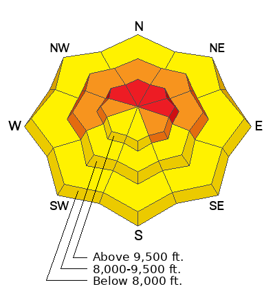
The overall danger on the Manti Skyline is CONSIDERABLE today.
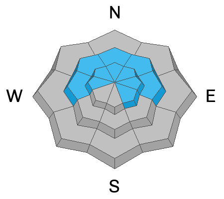
There is a HIGH danger on steep upper elevation slopes that face northwest through east. Human triggered avalanches are almost certain in this terrain today.
The bottom line is that the snowpack is unstable in many locations today and you'll want to use extra caution if you plan to travel into the mountains.
If you want to be sure to avoid being caught in an avalanche, simply avoid being on or below slopes that are steeper than 30˚.
Low
Moderate
Considerable
High
Extreme
Learn how to read the forecast here
Weather and Snow
Current Conditions: The northern end of the Skyline picked up 4 inches of new snow in the last 24 hours. The central and southern end only received 1 to 2 inches. The wind from the southwest has been strong enough to drift quite a bit of snow along the higher terrain. Currently, the wind doesn't look too bad down off the more exposed ridges but it's still blowing pretty strong along the highest peaks. Temperatures are very warm with most stations hovering around freezing.
Riding conditions are a mixed bag. You can find lots of nice turning out there but you can also find places where the snow is stiff and "punchy". Some places have a supportable base, others you'll sink right to the ground. The Fairview zone probably has the most punchy feeling snow like there's no base.
Mountain Weather: Skies start out sunny today then we'll see increasing clouds as the day goes on. Temperatures will be well into the 30s. Ridgetop wind is going to increase and looks like it'll be pretty strong from the southwest. We'll see one more little shot of snow tonight as a cold front moves through. I think 2 to 4 inches of new snow is reasonable to expect.
Recent Avalanches
I was able to spot a number of large avalanches that released naturally either late Friday night or early Saturday morning. This time frame was the peak of the instability. The avalanches were 2 to 4 feet deep and 200 to 400 feet wide. The most notable slides were in Wedding Ring Ridge near SR31, South Fork of Lake Canyon and Staker Canyon. I viewed these from a distance but there is no doubt they all broke into early season faceted snow.
Ad
Avalanche Problem #1
Persistent Weak Layer
Type
Location
Likelihood
Size
Description
It is imperative that you continue to avoid steep slopes in the higher terrain especially on slopes that face northwest through east. All of the storm snow that's fallen since Christmas Eve has stacked up on top of loose sugary snow. This is what we call a "Persistent Weak Layer" and it does not stabilize rapidly. We will continue to see problems with these faceted layers of old snow for a while still.
Here are clues that tell you things are unstable:
Recent avalanches. You may see some slides that released recently. This is the biggest clue that conditions are unstable.
Collapsing or "Whumpfing" of the snowpack underneath you. This is the loose sugary snow failing when you disturb it. If you are on a steep slope when this happens, it will avalanche.
Trenching or punching through to the ground with your boots. You'll notice that your track will drop deep through the snowpack and trench into very loose snow. If you step off your machine or skis or snowboard, you'll punch right through to the ground in many areas. Grab a handful of snow from down deep and you'll notice it's just like sugar. This is the dangerous Persistent Weak Layer of faceted snow.
Wind. Strong ridgetop wind today will drift more snow. This increases the danger by continuing to add weight on top of the Persistent Weak Layer. Watch for plumes coming off ridges and avoid places where the snow is getting deposited.
Avalanche Problem #2
Wet Snow
Type
Location
Likelihood
Size
Description
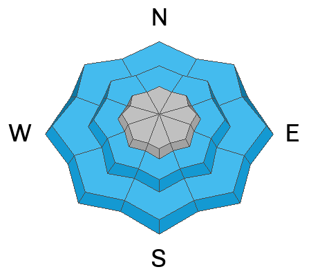
We are experiencing very warm temperatures today. The snow at the lower elevations is going to become wet and sloppy. This may produce some avalanche activity. Most likely just some smaller wet loose slides. However, it is wise if you are snowshoeing or skiing in the lower elevations to avoid being on or below all steep slopes that are wet and saturated. Keep an eye out for this situation in the mid elevations as well.
General Announcements
This forecast is from the U.S.D.A. Forest Service, which is solely responsible for its content. This forecast describes general avalanche conditions and local variations always occur.