UDOT PLANNED AVALANCHE CLOSURES!!

Forecast for the Provo Area Mountains

Dave Kelly
Issued by Dave Kelly on
Sunday morning, January 5, 2025
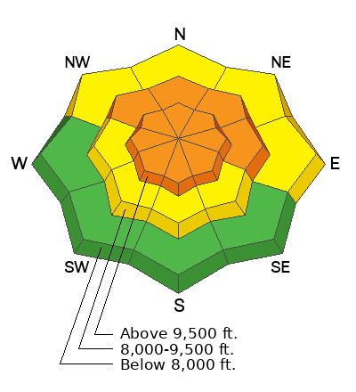
The avalanche danger is CONSIDERABLE in upper elevation and mid elevation northwest-north-east terrain for triggering a new or wind drifted snow avalanche that fails on a layer of buried facets. These avalanches could be 2'-4' deep and up to 800' wide.
As the snowpack continues to adjust, your best bet to enjoy this newest snow is to stay out of avalanche terrain and stick to lower angle slopes less than 30° in steepness.
Low
Moderate
Considerable
High
Extreme
Learn how to read the forecast here
Weather and Snow
Under partly cloudy skies, temperatures are in the teens °F. Winds are blowing from the west in the teens MPH at the lower ridgelines and blowing from the southwest in the teens gusting to the 20's at the 9,000' weather stations. Storm totals for the Provo Area mountains were light with a trace- 3" of snow/ .2" water reported. I would imagine the northern part of the Provo Forecast Region saw upwards of a 1' of snow and 1" of water.

Today, under partly cloudy skies look for warming temperatures with a high of 28-34 °F. Winds will blow from the southwest 5 gusting to 10 MPH at the lower ridgelines and from northwest 25 gusting to 40 MPH at the highest peaks. We can expect to see light snow with trace-1" expected.
Recent Avalanches
Yesterday, there was one report of an avalanche from just south of the Provo Region in the Mt. Nebo area. Some of the UAC staff were in the Tibble Fork area on Friday and found collapsing, cracking, and whumpfing in their travels. Check out all observations and avalanches HERE.
Ad
Avalanche Problem #1
Persistent Weak Layer
Type
Location
Likelihood
Size
Description
The buried persistent weak layer is still adjusting to the most recent series of storms. For the time being I will avoid traveling on or under slopes greater than 30° in steepness that may have this buried weak layer near the ground.
Our current setup is much more of a what a mountain environment with a continental snowpack sees every year. Former longtime director of the Utah Avalanche Center, Bruce Tremper talks more about differences between the snowpack types HERE.
Avalanche Problem #2
Wind Drifted Snow
Type
Location
Likelihood
Size
Description
Yesterday, there were reports of drifting snow in mid and upper elevation terrain. Cornices are sure fire signs that the slope below has been recently wind loaded. Look for and avoid any slope with rounded, hollow, drummy areas of wind loaded snow. Read more about wind loading HERE.
Additional Information
At the Utah Avalanche Center, we strive to learn from every avalanche incident and share insights to help others avoid similar accidents. We have all experienced close calls and understand how easily mistakes can happen. Our goal with these reports is to provide valuable learning opportunities.
The accident reports for the Porter Fork and Davenport Hill Accident have been completed. You can read them HERE.
General Announcements
This information does not apply to developed ski areas or highways where avalanche control is normally done. This forecast is from the U.S.D.A. Forest Service, which is solely responsible for its content. This forecast describes general avalanche conditions and local variations always occur.