Forecast for the Salt Lake Area Mountains

Nikki Champion
Issued by Nikki Champion on
Friday morning, November 29, 2019
Today, the avalanche danger is HIGH on all upper elevation and north-facing mid-elevation slopes. Continued snow and winds mean natural avalanches are likely, and human-triggered avalanches are very likely in steep wind drifted terrain. Mid-elevation slopes facing west through south and east have a CONSIDERABLE hazard. Slopes at low elevations didn't have that weak faceted basal layer or much a snowpack at all before this storm, thus they have a MODERATE danger.
The combination of an increasing snow load, strong winds and a weak base of faceted snow mean travel in avalanche terrain is not recommended.

What to do? The only viable strategy is to ride low angle slopes (less than 30 degrees in steepness) which are not steep enough for an avalanche and avoid being underneath steep slopes.
Low
Moderate
Considerable
High
Extreme
Learn how to read the forecast here
Avalanche Warning
IN EFFECT FROM 6 AM MST THIS MORNING TO 6 AM MST SATURDAY
FOR THE CENTRAL AND SOUTHERN WASATCH RANGE, INCLUDING THE WESTERN UINTAS.
THE AVALANCHE DANGER TODAY IS HIGH.
VERY DANGEROUS AVALANCHE CONDITIONS EXIST. HUMAN TRIGGERED AND NATURAL AVALANCHES ARE LIKELY. STAY OFF OF AND OUT FROM UNDER SLOPES STEEPER THAN 30 DEGREES. AVALANCHES MAY BE TRIGGERED FROM A DISTANCE OR FROM BENEATH STEEP SLOPES.
Special Announcements
The First Annual Statewide Avalanche Awareness Week is December 2-7. We have a week full of fun and educational events planned. Check out the schedule here.
Weather and Snow
Strong winds from the south-southeast continued for the last 24 hours, averaging 20-30 mph, and gusting near 50 mph. Throughout the day these winds should diminish and shift to the southwest and then the west as a cold front passes through this afternoon.
Mountain Temperatures increased overnight and are now in high teens and low 20s, but should begin dropping throughout the day.
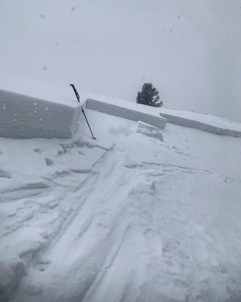
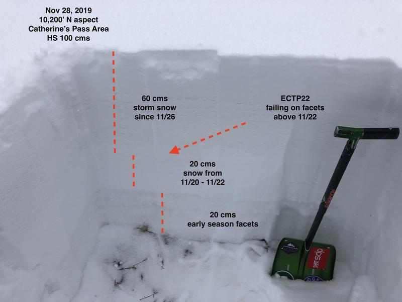
Across the Central Wasatch, 15-20 inches of new snow has fallen in the last 24 hours containing 1.0-1.5 inches of water.
We are not expecting much new snow this morning, but rates should pick back up this afternoon with 8 inches expected by sunset. Heavy snowfall on a cold northwest flow expected overnight.
Our week in review (including a summary of the early season) can be found HERE.
Recent Avalanches
Yesterday was an active day in the backcountry. Multiple natural and human triggered avalanches were reported across the region.
In Big Cottonwood Canyon, both natural and human triggered activity was seen. In 
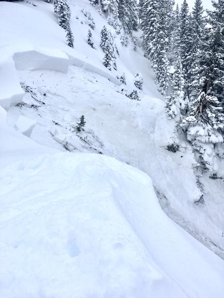
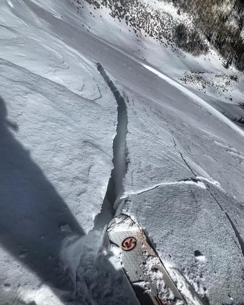
East Bowl of Silver Fork, an avalanche was remotely triggered on a steep northeast aspect at 9,900'. This avalanche failed 3 feet down in facets near the ground. The crown was 50' wide and ran 200'.
Northeast facing crown remote trigger - Big Cottonwood Canyon - PC: N. Grainger
Also in Silverfork, evidence of a natural avalanche was seen on NNW slope, failing 2 feet down in the facets above the November crust. The crown was about 240' wide. Multiple other remotely triggered avalanches and collapses were produced throughout the day that propagated to slopes over 35 degrees.
On the Park City Ridge, natural and human triggered activity was also seen. On 
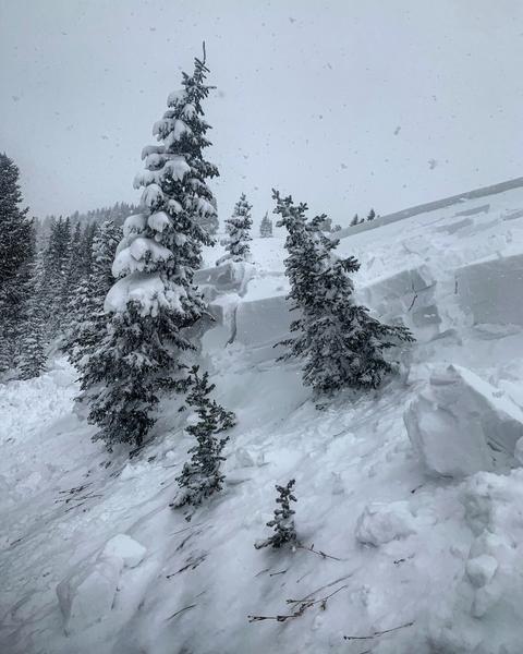
South Monitor Bowl an avalanche was remotely triggered from the ridgeline on steep north aspect at 9,400'. This avalanche failed 3 feet down on facets and was 400' wide.
North Facing Crown - S. Monitor Bowl - PC: M. White
S. Monitor Bowl Avalanche - PC: M. White
On the Park City Ridgeline, evidence of natural activity on steep north aspect at 9,8000' was also seen on Scotts Bluff. It failed on facets and ran 350'.
As well the resorts were reporting natural, human and explosive triggered avalanches, these avalanches were failing in facets above the November crust and occasionally stepping down the ground.
Check out all of our observations HERE.
Ad
Avalanche Problem #1
Persistent Weak Layer
Type
Location
Likelihood
Size
Description
The continued snow, wind, and water have caused us the scale to tip when it comes to the weak early season facets that covered the north end of the compass at upper elevations. Natural avalanches are likely and human triggered avalanches are very likely on the northerly upper elevation slopes. The snowpack is weak and dangerous. This was best demonstrated by all the human and natural activity that was seen all over the backcountry yesterday. With continued snowfall over the next 24 hours expect avalanche activity to continue.
Moving into the weekend, the most snow coverage is on those upper elevation north-facing slopes. While this might be appealing as the best coverage option, these are the slopes that will produce avalanches. The only option today is to stay out of avalanche terrain.
Here is a great photo highlighting the poor snowpack structure on a North aspect. This photo was taken in Catherines Bowl at 10,2000. PC: G. Gagne
Avalanche Problem #2
Wind Drifted Snow
Type
Location
Likelihood
Size
Description
The southerly winds continued overnight with gusts up to 50 mph. While these winds will be dropping throughout the day, we could still get gusts above 40 mph. On Thursday the wind drifts were reported as sensitive. Expect both hard and soft slabs of wind drifted snow, most widespread and suspect at upper northerly elevations, but wind drifts can be found deposited in protected areas in lower and mid-elevation bands.
Look for signs of sensitive wind drifted snow, such as cracking, such as and avoid them.
A great photo of wind drifted snow and cracking - S. Monitor Bowl - PC: M. White
Avalanche Problem #3
New Snow
Type
Location
Likelihood
Size
Description
The central Wasatch has gotten close to 3.5 feet of storm snow this week with additional snowfall throughout the day. These storm totals can lead to sluffing on steep terrain, as well as higher density slabs. New snow instabilities may increase during periods of higher precipitation.
General Announcements
This information does not apply to developed ski areas or highways where avalanche control is normally done. This forecast is from the U.S.D.A. Forest Service, which is solely responsible for its content. This forecast describes general avalanche conditions and local variations always occur.