Forecast for the Salt Lake Area Mountains

Nikki Champion
Issued by Nikki Champion on
Thursday morning, November 28, 2019
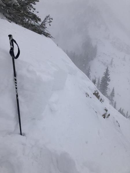
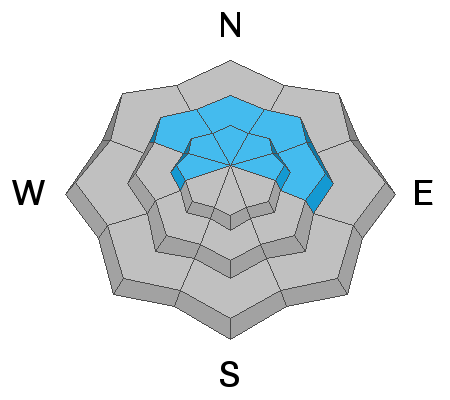
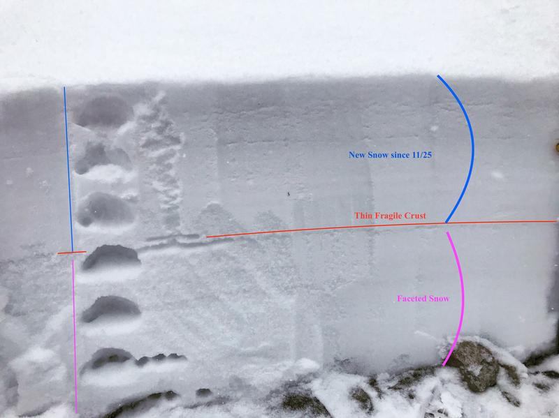
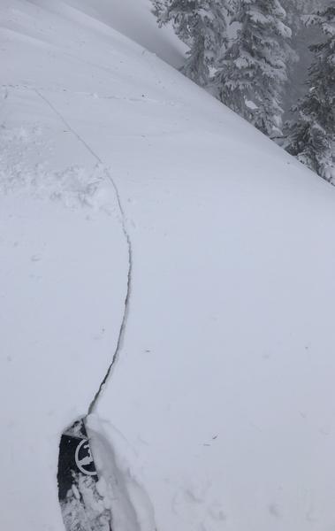
Today, the avalanche danger is HIGH on upper elevation northerly facing slopes. There is wind and a lot of snow. As the storm progresses throughout the day natural avalanches are likely, and human-triggered avalanches very likely in steep wind drifted terrain. The combination of an increasing snow load, strong winds and a weak base of faceted snow means travel in avalanche terrain is not recommended.

Upper elevation southerly facing slopes, and the mid-elevation bands will be CONSIDERABLE as dangerous avalanche conditions exist due to increased winds and steady snowfall.
Slopes at low elevations and south-facing mid-elevation slopes simply didn't have that weak faceted basal layer or much a snowpack at all before this storm, thus they have a MODERATE danger.

What to do? The only viable strategy is to ride low angle slopes (less than 30 degrees in steepness) which are not steep enough for an avalanche and avoid being underneath steep slopes. Even a shallow avalanche could drag you through stumps, rocks, and trees.
Low
Moderate
Considerable
High
Extreme
Learn how to read the forecast here
Avalanche Warning
IN EFFECT FROM 6 AM MST THIS MORNING TO 6 AM MST FRIDAY
FOR THE CENTRAL AND SOUTHERN WASATCH RANGE, INCLUDING THE WESTERN UINTAS.
THE AVALANCHE DANGER TODAY IS HIGH.
VERY DANGEROUS AVALANCHE CONDITIONS EXIST. HUMAN TRIGGERED AND NATURAL AVALANCHES ARE LIKELY. STAY OFF OF AND OUT FROM UNDER SLOPES STEEPER THAN 30 DEGREES. AVALANCHES MAY BE TRIGGERED FROM A DISTANCE OR FROM BENEATH STEEP SLOPES.
Special Announcements
The First Annual Statewide Avalanche Awareness Week is December 2-7. We have a week full of fun and educational events planned. Check out the schedule here.
Weather and Snow
Strong south southeast winds have been blowing throughout the forecast region for the last 24 hours, averaging 20-30 mph, and gusting above 50 mph. These winds should stay above 20 mph, and gust up 60 mph at the ridgelines today.
Temperatures have increased overnight and will be climbing up into the low 20s throughout the day. Across the Central Wasatch, 10-16 inches of new snow has fallen in the last 24 hours containing 0.7-0.9 inches of water.
Snowfall and wind should continue through Friday evening. This expansive storm will bring 8-10 inches today, and another 8-10 inches tonight. Then a cold front is expected to move in from the southwest supporting the orthographic for a westerly flow. Winds should gradually decrease with this frontal change.
Recent Avalanches
Yesterday multiple natural, remote and human triggered avalanches were reported both in Little and Big Cottonwood Canyons. These avalanches are a clear sign that with more snow and wind today, there will be more avalanches.
There was one small natural avalanche on Rocky Point. It was a 2’ soft slab of wind drifted snow that was 150’ wide. This was at 10,000’ on an East Aspect.
Two human triggered avalanches were reported. On Davenport Hill in Silver Fork, a snowboarder intentionally triggered a 12” deep soft slab Problem. This was at 10,000’ on a Northeast Aspect. In Silver Fork on the Silver Fork Headwall, a skier remotely triggered a 12” deep soft slab that was 30’ wide and ran 200’. This was at 9,900’ on a North Aspect.
Multiple other human triggered avalanches reported on East-North East facing slopes, running up to 600' on slopes approaching 40 degrees. Crowns were reported to be 4-16" deep and 10-50' wide.
Photo of Rocky Point avalanche crown (PC: Brucei)
As well the resorts were reporting unpredictable remote and intentional triggered avalanches breaking on top the October crust in a layer of facets. These conditions were described as "weird, scary and something to be afraid of. "
Check out all of our observations HERE.
Ad
Avalanche Problem #1
Persistent Weak Layer
Type
Location
Likelihood
Size
Description
Moving into our second storm system of the week, we are finally hitting the tipping point in which the combination of strong winds and new snow is enough to overload the weak old faceted snow that covered the entire north end of the compass at upper elevations. Natural avalanches are likely and human triggered avalanches are very likely on the northerly upper elevation slopes. Multiple parties triggered an avalanche or collapse in old facets on the top of the October crust yesterday, and ski patrols were reporting scary, unpredictable remote triggered avalanches. These avalanches are a clear indication that the underlying snowpack is weak and dangerous. With another inch or more of water in the forecast, and winds expected to stay strong throughout the next 48 hours avalnache activity will continue.
Moving into the holiday weekend, the most snow coverage is on those upper elevation north-facing slopes. While this might be appealing as the best coverage option, these are the slopes that will produce avalanches. The only option today is to stay out of avalanche terrain.
The photo below shows about a foot of faceted snow below the increasing new snow and wind load. The photo was taken in Upper Little Cottonwood Canyon at 9,500 on a NE Aspect. (PC: B. Torrey)
Avalanche Problem #2
Wind Drifted Snow
Type
Location
Likelihood
Size
Description
Yesterday the wind blew hard with gusts up to 70 mph in Little Cottonwood Canyon. These winds will continue for the next 24 hours. Expect both hard and soft slabs of wind drifted snow. 1-2' wind drifts can be found at all aspects, most widespread at upper elevations, but can be found deposited in protected areas in lower and mid-elevation bands. This wind drifted snow will be especially suspect on the North end of the compass where it sits on top of the old, weak, faceted snow. Look for signs of fresh wind drifts and avoid them.
Shooting Crack on a northeast facing slope that was freshly wind loaded - PC: K. Mays
Avalanche Problem #3
New Snow
Type
Location
Likelihood
Size
Description
Soft slab avalanches in the new snow are a definite possibility today for several reasons. One is simply the amount of new snow and how quickly it has been falling. Second is that temperatures have warmed (about 10 degrees warmer than yesterday) and the new snow may be upside down which means there is warmer denser snow on top of colder lighter snow.
General Announcements
This information does not apply to developed ski areas or highways where avalanche control is normally done. This forecast is from the U.S.D.A. Forest Service, which is solely responsible for its content. This forecast describes general avalanche conditions and local variations always occur.