Forecast for the Salt Lake Area Mountains

Drew Hardesty
Issued by Drew Hardesty on
Monday morning, November 25, 2019
The avalanche danger will be on the rise with the first of two storms. The danger today will start out at LOW, move to MODERATE, and possibly move to CONSIDERABLE if we see enough snow and wind. Remember: If snow is the question, Terrain is the answer: choose low angle terrain not beneath anything steep. There will come a time (late afternoon?) when we will be able to trigger avalanches from a distance or below.
Low
Moderate
Considerable
High
Extreme
Learn how to read the forecast here
Special Announcements
Alta Ski Area is now closed as they prepare for opening on the 29th. Access to Grizzly Gulch and the Catherine's area via the Summer Road will remain open. The open and closed resorts have different uphill travel policies. Check with each resort for the current information.
Terrain in unopened resorts must be treated as backcountry.
The First Annual Statewide Avalanche Awareness Week is December 2-7. We have a week full of fun and educational events planned. Check out the schedule here.
Click on the Education menu on our webpage for a full list of classes from the UAC and other providers. Check out the Know Before You Go eLearning program for free, online, avalanche classes.
Weather and Snow
First the bad news: The Alta Guard station has recorded snowfall from November to April since 1945 (Alta Snowfall by Month chart HERE). We currently have the driest November on record with 3" for the month. 1977 recorded 13" for the month of November.
Now the good news: We'll likely move out of last place by tomorrow morning and certainly later in the week as two storms are set to bring significant snowfall to the mountains. (Though we'll still be a bit shy of 94/95 November snowfall of 205").
Currently, skies are partly cloudy but as of 530, the radar tells the tale: snowfall should begin this morning and last throughout the day with perhaps 4-8+" by tonight with another couple overnight. The cold front crashes the dry spell by about midday.
Temps are in the mid to upper twenties but will fall to the low teens and near 10°F tonight. Winds are westerly at 15mph and may be gusty at times from the northwest with frontal passage.
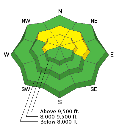
1-2 feet of snow exists on the shady mid and upper elevation slopes of the upper Cottonwoods, and 6-18 inches at the upper elevations along the Park City ridgeline. Southeast through south through west facing terrain generally has this storm snow over bare ground.

More good news: we'll see significant snowfall (and some wind) with the two storms this week.
More bad news: the storm snow will fall on an exceedingly weak base and avalanches will be all but certain, becoming more likely and more dangerous as the week wears on. See more below -
Recent Avalanches
Ski area avalanche control work produced a couple shallow 4-8" soft slabs in the highest most exposed terrain of upper Little Cottonwood canyon yesterday.
Ad
Avalanche Problem #1
Persistent Weak Layer
Type
Location
Likelihood
Size
Description
As described above (and below), we have exceedingly weak snow - all we need is a slab. It remains to be seen if we see enough snow and wind today, but if we do human triggered avalanches will be likely and routinely triggered from a distance or from below. Collapsing and cracking will be tell-tale signs of immediate instability and if the snow piles up by the afternoon, steep west to north to east facing terrain must be approached with great caution.
Avalanche Problem #2
New Snow
Type
Location
Likelihood
Size
Description
Sluffing will commence almost immediately on the steepest slopes of the mid and upper elevations in areas that had pre-existing snow. These are the west to north to east facing slopes. The surface snow is so weak that the new snow will bond poorly and scrape down to the underlying November 20th crust. These point-release avalanches will run naturally and with human provocation and may leave decent debris piles by the afternoon.
Additional Information
If you're getting out and about, please help us out and submit your observations to us via this website or just as easily on your smartphone.
General Announcements
This information does not apply to developed ski areas or highways where avalanche control is normally done. This forecast is from the U.S.D.A. Forest Service, which is solely responsible for its content. This forecast describes general avalanche conditions and local variations always occur.