Forecast for the Salt Lake Area Mountains

Trent Meisenheimer
Issued by Trent Meisenheimer on
Sunday morning, November 24, 2019
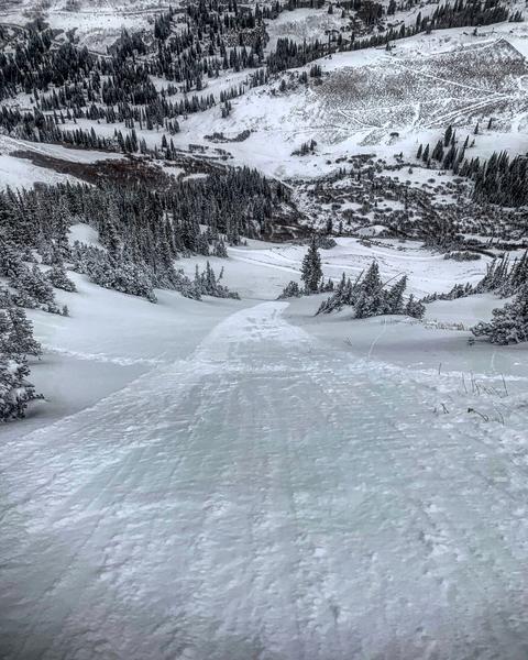
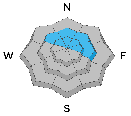
Human triggered avalanches may be possible on upper elevation wind drifted slopes on steep northwest to northeast facing terrain. This includes shallow long running sluffs. Evaluate snow and terrain carefully.
Remember that traumatic injury is likely in any early season avalanche accident.

Drew Hardesty will post the full forecast by 7am Monday the 25th. We are expecting changing avalanche conditions and a rising danger throughout the week with new snow and wind on the way.
We are posting observations every day, so submit an avalanche or observation HERE. Read observations HERE.
Low
Moderate
Considerable
High
Extreme
Learn how to read the forecast here
Special Announcements
Alta Ski Area is now closed as they prepare for opening on the 29th. Access to Grizzly Gulch and the Catherine's area via the Summer Road will remain open.
Please work with Alta, as they allowed great uphill access this fall and are keeping the summer road open.
The open and closed resorts have different uphill travel policies, which may change daily as they work towards opening for the season. Check with each resort for the current information.
Terrain in unopened resorts must be treated as backcountry.
The First Annual Avalanche Awareness Week is December 2-7 We have a week full of fun and educational events planned. Check out the schedule here.
As part of your early season tune-up, consider taking an avalanche class. We have lots of avalanche education classes listed already, from Know Before You Go to Companion Rescue to our Backcountry 101. Click on the Education menu on our webpage for a full list of classes from the UAC and other providers. Check out the Know Before You Go eLearning program for free, online, avalanche classes.
Weather and Snow
As this first storm system diminishes, high pressure begins to build over our region again. Storm totals are 5-6", favoring the upper reaches of Big Cottonwood Canyon and the Park City ridgeline.
Isolated snow showers possible this afternoon, with things clearing out into the weekend. North northwest winds are expected to stay light, not predicted to gust above 25 mph with mountain temperatures hovering near 30 degrees. A more active pattern is setting up for next week, which should be led by a cold front Monday morning.

1-2 feet of snow exists on the shady mid and upper elevation slopes of the upper Cottonwoods, and 6-20 inches at the upper elevations along the Park City ridgeline. Southeast through south through west facing terrain generally has this storm snow over bare ground.
Recent Avalanches
Photo of a long running sluff in Little Cottonwood Canyon - Mark White - Full Observation HERE.
Ad
Avalanche Problem #1
Persistent Weak Layer
Type
Location
Likelihood
Size
Description
As this first low pressure system breaks for the weekend, continue to approach upper elevation wind drifted slopes with caution. Upper elevation northerly terrain that has received the most snow and wind is still suspect. Collapsing and cracking are immediate signs of instability.
While we only pulled about 6" of snow out of this system, it is not bonding well and sitting on top of a thin superficial crust in protected areas. This thin crust can lead to fast running sluffs in steep upper elevation terrain. Even a shallow sluff could pull you throw exposed terrain, rocks, and stumps with this early season coverage.
Moving forward into the next storm system, we know that a weak interface of facets and crusts exists across all northerly upper elevation slopes. Added snow and wind this coming week could lead to deeper and more widely propagating avalanches failing within this weak snow.
General Announcements
This information does not apply to developed ski areas or highways where avalanche control is normally done. This forecast is from the U.S.D.A. Forest Service, which is solely responsible for its content. This forecast describes general avalanche conditions and local variations always occur.