TONIGHT at 7PM at Rocksteady Bodyworks in Holladay an interactive discussion on the State of the Snowpack. Read these blog posts before going: LOW Danger
Chapter 1,
Chapter 2,
Chapter 3,
Chapter 4. You can find them all under our Blog page in the Menu above.
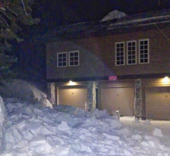
HEADS UP for ROOF AVALANCHES: Warm temperatures and rain will make the snow on many roofs unstable. Please alert your friends and family who may not normally check avalanche forecasts. Roof avalanches can be deadly especially for children. Below is a photo (D. Richards) of a roof avalanche this morning in Little Cottonwood Canyon. Notice the dog for scale.
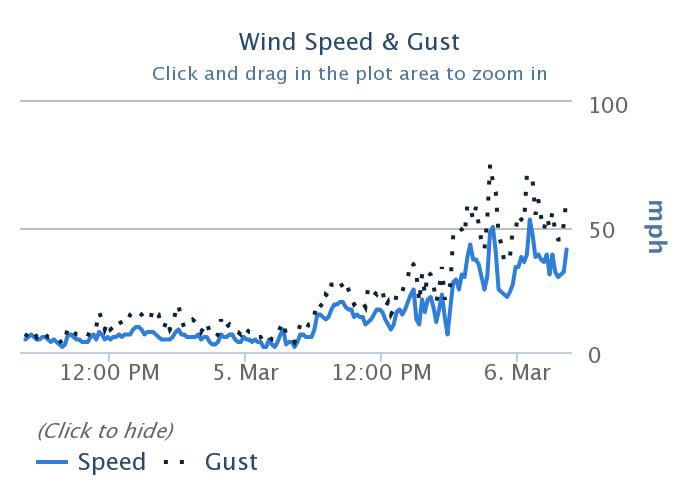
Currently: Strong southerly winds began blowing yesterday afternoon. This morning they are averaging about 20-25 mph at most ridgetops and gusting 40-60 mph. At 11,000 feet some gusts overnight reached 80 mph. Temperatures are relatively warm this morning and above freezing generally below 8500 feet. Near 10,000 feet, temperatures are in the upper 20's F. Only an inch or two of snow had fallen as of 4 a.m.
Today: A warm, wet, and windy storm will bring 4-8 inches of dense snow today. Snowfall could be heavy at times. Temperatures should warm a bit this morning with the approaching storm. The rain-snow line will be around 7500 feet today. It should start dropping slowly as temperatures cool late this afternoon. Strong southerly winds will continue.
This week: Snowfall should continue through tonight with another 2-4 inches falling. Another storm will arrive Friday. This one will come from the northwest with much colder temperatures and lighter snow.
The graph below is from 10,000 feet on the Park City Ridgeline (
Jupiter Station) showing increased southelry winds that started yesterday.