Forecast for the Skyline Area Mountains

Brett Kobernik
Issued by Brett Kobernik on
Friday morning, December 30, 2022
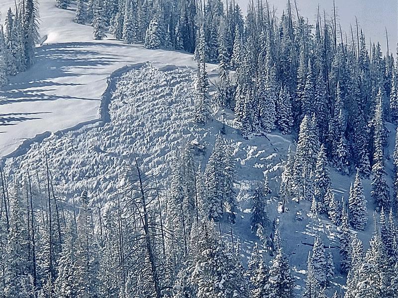
INCREASING AVALANCHE DANGER TODAY AND THROUGH THE WEEKEND!!
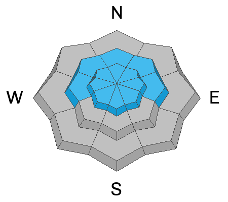
The overall avalanche danger is rated CONSIDERABLE today.
As new snow stacks up, human triggered avalanches will become more likely.
Avalanches can be triggered from a distance.
Continue to avoid being on or below slopes steeper than 30 degrees.
Low
Moderate
Considerable
High
Extreme
Learn how to read the forecast here
Avalanche Watch
What The avalanche danger is expected to increase to HIGH this weekend.
When The Watch is in effect from 6am MST this morning to 6am MST Saturday and will most likely turn into an Avalanche Warning on Saturday.
Where For most mountains in Utah including Wasatch Range, Bear River Range, Uinta Range, Manti-Skyline, La Sal and Abajo Ranges, Fish Lake Region, Pavant Range, Tushar Range, and Cedar City area mountains.
Impacts Very dangerous avalanche conditions are expected as a series of storms will arrive this weekend with significant snowfall, substantial water amounts, and very strong winds. Both human-triggered and natural avalanches will become likely. Stay off of and out from under slopes steeper than 30 degrees.
Weather and Snow
Current Conditions: Riding conditions remain excellent with lots of fresh powder on the surface. The wind has been light from the southwest. Temperatures were in the mid teens on Thursday and are now around 20˚F.
Mountain Weather: A large windy and warm storm system is moving in today and will last through the weekend. We should see snow start later this morning with a few inches of accumulation possible today. Wind will be from the southwest today with fairly light speeds. Snowfall will get heavier tonight and we should see around a foot of fresh snow by Saturday morning. Temperatures will be warm through Saturday making for higher density snow. Southwest wind gets strong tonight and stays pretty strong all weekend. Periods of snow will continue Saturday and Sunday and we could see an additional foot. Temperatures start to cool on Sunday.
Recent Avalanches
There was a sizable avalanche triggered from a distance by snowmobilers in 12 Mile Canyon on Thursday. This clearly demonstrates that the snowpack is not stable yet. There are many other spots around the Skyline where a person could trigger something similar.
Ad
Avalanche Problem #1
Persistent Weak Layer
Type
Location
Likelihood
Size
Description
The buried Persistent Weak Layer of sugary faceted snow is still active and will become more active with the storm moving in today and through the weekend. Yesterday's snowmobile triggered avalanche is proof. My partner and I experienced a couple of HUGE collapses where the snowpack "whumpfed" under us, we felt the snowpack drop, and there were cracks throughout the snow. The combination of the buried weak layer and the large windy storm this weekend could produce some VERY large natural avalanches.
The tricky thing is that the buried weak layer has gained quite a bit of strength in many areas. In other areas the layer remains quite weak. What this means is it's like we have land mines scattered about. Some slopes will stay in place, others will avalanche and there's no sure way to tell which ones are dangerous and which ones are safe. Your only strategy is to continue to avoid steep terrain until the buried weak layer has gained more strength and is stable.
General Announcements
This forecast is from the U.S.D.A. Forest Service, which is solely responsible for its content. This forecast describes general avalanche conditions and local variations always occur.