Forecast for the Skyline Area Mountains

Brett Kobernik
Issued by Brett Kobernik on
Thursday morning, December 29, 2022
The overall avalanche danger is rated CONSIDERABLE today.
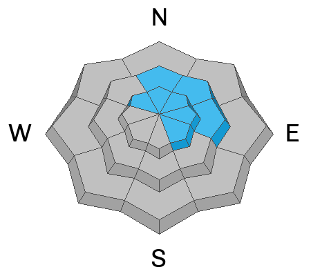
The most likely places to trigger an avalanche is on slopes steeper than 30˚ that face northwest through southeast above 9500'.
The avalanche danger is lower in lower elevations.
I would recommend avoiding avalanche terrain (slopes steeper than 30˚) until the weekend storms pass and the snowpack settles and stabilizes.
Low
Moderate
Considerable
High
Extreme
Learn how to read the forecast here
Weather and Snow
Current Conditions: The recent storm greatly improved riding conditions with nice powder snow on the surface. Storm totals were right about a foot in most locations with up to 16" in the most favored locations. The wind was moderate from the northwest on Wednesday and drifted some snow along the exposed ridges. The wind was not getting down into terrain below the higher ridges. Temperatures continue to drop with readings around 15˚F this morning.
Mountain Weather: We may see a brief period of partial clearing today but I'm anticipating mostly cloudy skies. Temperatures will stay in the teens and the wind will be light from the southwest. We're going to have a stormy weekend starting mid day Friday with periods of snow and wind through Sunday night. 1 to 2 feet of new snow is possible by the time it's finished.
Ad
Avalanche Problem #1
Persistent Weak Layer
Type
Location
Likelihood
Size
Description
The most dangerous situation out there today is the chance for triggering an avalanche that breaks deep into the Persistent Weak Layer that formed in November. (click/tap here for updated details on this weak layer) The most likely places to trigger these are in the upper elevation steep slopes that face northwest through southeast.
My partner and I did not find the snowpack to be very sensitive on Wednesday. Snow stability tests were stubborn and did not break clean. We did experience some minor local collapsing under skis. Overall, it appears that the snowpack is heading in a good direction. I am hopeful that once these storms pass and things settle, we can put the November weak layer to bed.
DON'T GET TOO COMFORTABLE JUST YET THOUGH!! A BURIED LAYER OF SUGARY FACETED SNOW IS NOTORIOUS FOR DECEIVING US. Stick to slopes less steep than 30˚ until we get a good handle on how the pack is adjusting to these new loads.
General Announcements
This forecast is from the U.S.D.A. Forest Service, which is solely responsible for its content. This forecast describes general avalanche conditions and local variations always occur.