Forecast for the Skyline Area Mountains

Brett Kobernik
Issued by Brett Kobernik on
Wednesday morning, January 11, 2023
The overall avalanche danger is rated CONSIDERABLE today.
Human triggered avalanches are likely within the new snow.
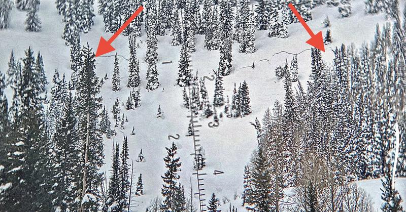
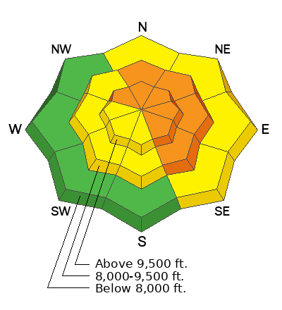
It is possible that an avalanche may break deep into the old November weak layer especially on heavily wind loaded slopes.
You will want to avoid being on or below slopes that are steeper than 30˚ today.
Low
Moderate
Considerable
High
Extreme
Learn how to read the forecast here
Weather and Snow
Current Conditions: Wow. Yet again the northern Skyline picked up the most new snow with another 10" in the last 24 hours. This brings totals since Monday up to almost 2 feet. The central and southern Skyline received around 6 inches overnight and totals are around a foot since Monday. Westerly wind has been strong along the higher terrain and has gotten down into the canyons at certain times as well. Temperatures finally cooled off and are down around 20˚F.
Mountain Weather: Snowfall should end this morning at some point. Strong wind from the west should slow as the day goes on. Temperatures will remain around 20˚F. We'll have a break from snowfall for a couple of days and then it looks like another storm will move in Saturday night. Overall, the weather pattern looks to remain active with more storms on the way.
Recent Avalanches
There was some natural slab avalanche activity within the new snow early Tuesday. The most notable avalanche reported was from the Electric Lake area. The fracture was around a foot deep and 250 wide. The good news is that it doesn't appear to have broken deep into the November faceted weak layer. MORE DETAILS HERE
Ad
Avalanche Problem #1
Wind Drifted Snow
Type
Location
Likelihood
Size
Description
Strong wind from the west along the ridgetops has drifted snow into sensitive slabs. Some of these slabs are releasing naturally. Others are just waiting for a human trigger. There is plenty of new snow and it is sensitive enough that you don't want to mess around on any steep slopes today. The good news is that this type of new snow instability generally settles out and stabilizes within a few days.
Avalanche Problem #2
Persistent Weak Layer
Type
Location
Likelihood
Size
Description
This storm is going to be a good test on the old November Persistent Weak Layer. We are receiving a large amount of new snow (more pronounced on the north Skyline) as well as strong wind. The wind will have tremendously loaded slopes on the east half of the compass. It will be interesting to see if any natural avalanches break deep into the faceted weak snow from November.
For today, all bets are still off. Continue to avoid steep slopes.
General Announcements
This forecast is from the U.S.D.A. Forest Service, which is solely responsible for its content. This forecast describes general avalanche conditions and local variations always occur.