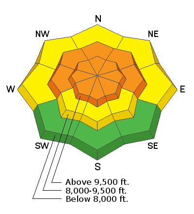
Forecast for the Salt Lake Area Mountains

Issued by Evelyn Lees on
Friday morning, March 8, 2019
Friday morning, March 8, 2019
The avalanche danger is CONSIDERABLE at the upper elevations, and on northwest through easterly facing mid elevation slopes. New snow avalanches 1 to 2 feet deep can be triggered, along the ridge lines and mid slope. The avalanche danger will peak this afternoon during frontal passage and or any time it snows heavily or the winds pick up. Use cautious route finding and conservative decision making today. A MODERATE avalanche danger exists on most other mid and low elevation slopes for triggering a new snow slide.
The warm, new snow instabilities strengthen quickly, so patience for just a day or two before stepping into bigger, steep terrain. For now, the vast untracked acres of surfy snow on low angle slopes offer safer terrain.

Low
Moderate
Considerable
High
Extreme
Learn how to read the forecast here


