Forecast for the Salt Lake Area Mountains

Trent Meisenheimer
Issued by Trent Meisenheimer on
Monday morning, December 9, 2019
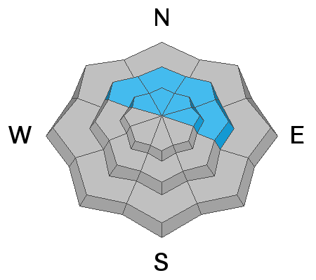
CONSIDERABLE danger exist on mid and upper elevation northwest through easterly facing aspects. Large and deadly human triggered avalanches 2-4' are possible and are likely to be triggered from a distance or well above you.
MODERATE danger exists for wind drifted snow at all mid and upper elevations where fresh drifts of wind blown snow could avalanche. Look for and avoid rounded, pillowy looking snow on any steep slope.
Low
Moderate
Considerable
High
Extreme
Learn how to read the forecast here
Special Announcements
Thanks to the generous support of our Utah ski resorts and Ski Utah, we have discount lift tickets available. All proceeds from these go towards paying for avalanche forecasting and education! Get your tickets HERE.

Get one of these cool t-shirts to support the UAC and other avalanche centers across the U.S. INFO
Weather and Snow
As the weekend storm comes to an end and spins off to our east we will continue to see scattered snow showers throughout the day. The 24 hr snow totals are generally 6-12" of snow containing 0.80-1.57" of water. The northerly winds have finally relaxed and are currently blowing 5-10 mph gusting into the 20's at upper elevations. Below the ridgelines the winds are generally calm. 10,000' temperatures are in the upper teens °F while the lower trailhead temps hover in the upper 20's °F
Dense, spongy, graupel laden snow was laid down yesterday morning improving the riding conditions on almost all aspects and elevations. Low angle terrain will be surfy and fast.
Recent Avalanches
Yesterday, we had a report that a skier triggered a slab avalanche on Square Top along the Park City Ridgeline. The avalanche was 120' wide and 20" deep. No injures. Check out all the current observations HERE.
Our neighbors to the east in Colorado just reported an avalanche fatality on South Diamond Peak. The avalanche was described as 2 to 3 feet deep, very wide, and running close to 500 feet vertically. She was caught and fully buried. Members in her group performed the rescue and recovered her from the snow, but she did not survive.

In the Bear River Range just north of the border into Idaho, two snowmobilers on Saturday were caught and carried with one partial burial in an avalanche but ended up ok. INFO.
Ad
Avalanche Problem #1
Persistent Weak Layer
Type
Location
Likelihood
Size
Description
Mid and upper elevation northwest through easterly facing terrain has the perfect recipe for deep and dangerous avalanches. In the terrain highlighted by the blue in the locator rose graphic (to the left) - you will find a dense slab roughly 2 to 4 feet deep that sits on top of very weak faceted snow at the ground (strong over weak). The weekend storm has added more weight and stress to this already fragile set up and conditions today will be more active as a result. Right now there are two strategies for avoiding this problem:
1. Simply avoid this snow structure by staying on southerly aspects, where faceted snow doesn't exist.
2. Or travel on slopes no steeper than 30° with nothing steeper above, below or adjacent to you.
Unfortunately, it looks like this problem is here to stay for awhile. The good news: Southerly facing terrain will have good turning and riding conditions today where you don't have to deal with this avalanche problem.
Picture: Northerly facing slope at 9,500' in elevation. Showing the slab and weak layer set up.
Avalanche Problem #2
Wind Drifted Snow
Type
Location
Likelihood
Size
Description
Sensitive drifts of wind blown snow have been created by northerly winds. For the past 24 hrs the northwest wind has been relentless, blowing at speeds of 10-15 mph gusting into the 30's across the upper elevations. These drifts could be a foot or more deep at the higher elevations. On slopes with hard, slick sun crusts the graupel snow from yesterday might act as the weak layer allowing the new snow to crack and propagate (see video HERE).
Test slopes and quick hand pits often provide some clue to the situation. Look for and avoid these slabs of wind drifted snow on steep slopes. Wind drifts often look, rounded, smooth, and cracky. If you see a slope that’s been scoured or eroded, think about where the snow may have been deposited.