Forecast for the Salt Lake Area Mountains

Greg Gagne
Issued by Greg Gagne on
Friday morning, December 6, 2019
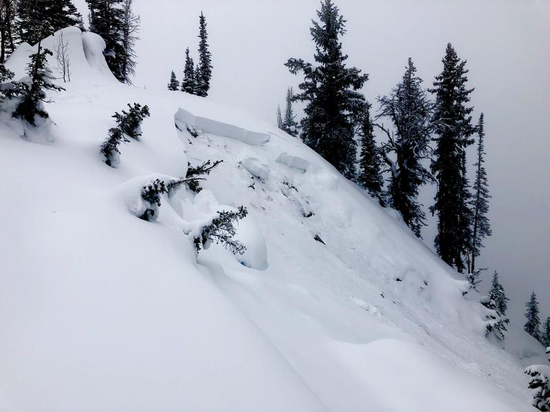
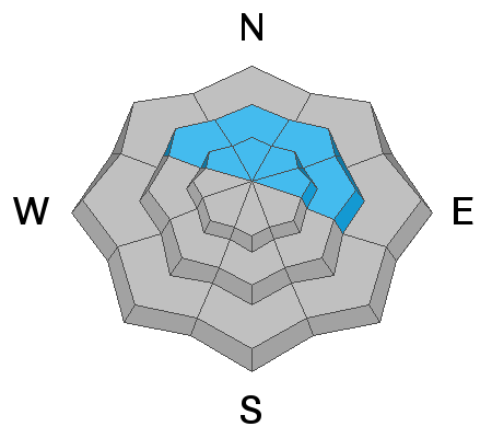
The avalanche danger is CONSIDERABLE on mid and upper elevation aspects facing northwest, through north, and east where a persistent weak layer of snow buried down 2-3' exists. A MODERATE hazard exists at the upper elevations for other avalanche concerns including pockets of fresh wind slabs as well as sluffing in recent storm snow on steeper aspects.
Although the hazard is otherwise Low, there may also be some sluffing in loose wet snow at lower elevations as well as steeper southerly aspects from warming temperatures today.
Low
Moderate
Considerable
High
Extreme
Learn how to read the forecast here
Special Announcements
The first UAC podcast of the season " Early Season Essentials with Program Director Bo Torrey" check it out HERE.

The Supreme area of Alta ski area is now closed to the public as the ski patrol gets this terrain ready for the season.

Get one of these cool t-shirts to support the UAC and other avalanche centers across the U.S.
Weather and Snow
Currently, weather conditions include mountain temperatures in the low 20's F. Winds are out of the south/southwest and light - less than 10 mph with a few gusts in the teens. On Thursday 3-5" of dense snow was reported throughout the Salt Lake mountains, containing 0.2-0.5 inches of water.
For today, you can expect partly-cloudy skies above 8500', with periods of fog below. Mountain temperatures will rise into the low and mid 30's at mid-elevations, and mid to upper 20's F. along upper elevation ridgelines. Winds will be from the south/southwest and light, with a few gusts into the teens.
A more promising system is expected later Saturday night into Sunday, with perhaps 8-12" of snow by Monday.
Visit the Week in Review for a summary of the weather and avalanche activity from the past week.
Recent Avalanches
Yesterday's dense snow was largely unreactive, however, a few observers noted some cracking in shallow fresh wind slabs, including one on a southeast aspect in Cardiff Fork (observation).
The human-triggered avalanche that caught my attention was a remotely-triggered slide in upper Little Cottonwood, failing 3' down on weak faceted snow down near the ground (observation). We'll talk more about the significance of this avalanche below.
You can view all reported avalanche activity here.
Ad
Avalanche Problem #1
Persistent Weak Layer
Type
Location
Likelihood
Size
Description
There are numerous indications why the persistent weak layer down near the ground remains a significant avalanche concern. This includes continued reports of collapsing as well as yesterday's remotely-triggered slide on Patsy Marley in upper Little Cottonwood.
This weak snow is down near the ground, buried underneath 2-3' of a strong slab of snow from the Thanksgiving storm cycle. This poor snow structure can be found at the mid and upper elevations, on aspects facing northwest, through north, and east. The photo below (C. Hughes) depicts this dangerous structure of strong snow over weak snow:
The video below (link) further illustrates our primary avalanche problem.
It will take patience while allowing time for this layer to heal, and this layer may become increasingly active later this weekend with an additional load of snow and wind. Remember, existing tracks on a slope are zero indication of stability. For now, I am avoiding all steep northerly aspects.
Additional Information
On Saturday, my regular touring partners and I are planning on spending time refreshing rescue skills. This includes (1) beacon practice, (2) probing, and (3) strategic shoveling. I encourage others to spend time practicing these skills. Need to learn these skills or take a refresher, consider signing up for a companion rescue course!
General Announcements
This information does not apply to developed ski areas or highways where avalanche control is normally done. This forecast is from the U.S.D.A. Forest Service, which is solely responsible for its content. This forecast describes general avalanche conditions and local variations always occur.
Remember your information can save lives. If you see anything we should know about, please help us out by submitting snow and avalanche conditions. You can also call us at 801-524-5304, email by clicking HERE, or include #utavy in your tweet or Instagram.
To get help in an emergency (to request a rescue) in the Wasatch, call 911. Be prepared to give your GPS coordinates or the run name. Dispatchers have a copy of the Wasatch Backcountry Ski map.
Backcountry Emergencies. It outlines your step-by-step method in the event of a winter backcountry incident.
If you trigger an avalanche in the backcountry, but no one is hurt and you do not need assistance, please notify the nearest ski area dispatch to avoid a needless response by rescue teams. Thanks.
  • Salt Lake and Park City – Alta Central (801-742-2033), Canyons Resort/PCMR Dispatch (435-615-1911)
  • Ogden - Snowbasin Resort Dispatch (801-620-1017), Powder Mountain Dispatch (801-745-3772 x 123)
  • Provo - Sundance Dispatch (801-223-4150)