Forecast for the Salt Lake Area Mountains

Greg Gagne
Issued by Greg Gagne on
Monday morning, December 24, 2018
For today the avalanche danger is MODERATE at the upper elevations. Watch for fresh wind drifts on all aspects at the upper elevations. There also exists an isolated chance of triggering a larger avalanche breaking down near the ground in thinner snowpack areas above about 9500' on aspects facing north through east. Elsewhere the hazard is LOW.
Low
Moderate
Considerable
High
Extreme
Learn how to read the forecast here
Special Announcements
The new UAC IOS mobile app is now available on the app store. Check out the new "My Weather" feature.
Weather and Snow
Skies are overcast with light mountain snow showers. Overnight a trace to 2” of snow has fallen. Westerly winds have increased since Sunday evening, and are averaging in the teens with gusts in the 20’s and 30’s mph at the mid and upper elevations, with even stronger gusts at 11,000’
Recent storm snow has settled out to 3-6" and riding conditions remain good with a soft and supportable snow surface.
I guess we weren't as good as I thought we've been. We may pick up another trace to 2” of snow before partial clearing this afternoon. Winds will be westerly, averaging in the teens and 20’s mph, with gusts in the 30’s mph at the higher elevations. Winds are expected to diminish as the day progresses. Mountain temperatures will be in the 20’s F. We may pick up another trace to 2" overnight, and a few inches possible later on Christmas night. A chance for snow showers later this week, with colder temperatures.
Recent Avalanches
The only avalanche activity reported on Sunday was from Pioneer Peak in the Brighton backcountry on a NE-facing slope at 10,400'. This was a wind slab 18" thick and 30' wide, running full track. (Avalanche Observation.) Thanks to everyone who submits observations, especially when it involves recent avalanches.
Yesterday, my partner and I visited the avalanche in Days Draw (Avalanche Observation) that was triggered on Saturday December 22. What was notable about this avalanche was that it failed on a layer of early-season facets, and had not been recently wind-loaded. This was on a NE-facing slope at 9900' in steep, rocky terrain with a thin snowpack. The crown averaged 12-24" and it propagated approximately 75'. More comments under avalanche problem #2 about how this avalanche occurrence relates to the current avalanche forecast.
Ad
Avalanche Problem #1
Wind Drifted Snow
Type
Location
Likelihood
Size
Description
Southwest through northwest winds have increased since 7 PM Sunday, and you can expect to find fresh wind drifts at the upper elevations, especially above 10,000'. Although these drifts will be mostly on easterly aspects, cross-loading is possible on all aspects. Any fresh wind drifts your encounter are likely to be smaller pockets, however the wind slab that released on east-facing Reynold Peak (Avalanche Observation) on Saturday is a reminder of the potential for these drifts to be larger than expected.
Avalanche Problem #2
Persistent Weak Layer
Type
Location
Likelihood
Size
Description
We had hoped our persistent weak layer of weak, faceted snow down near the ground had settled down for a long winter's nap, but 
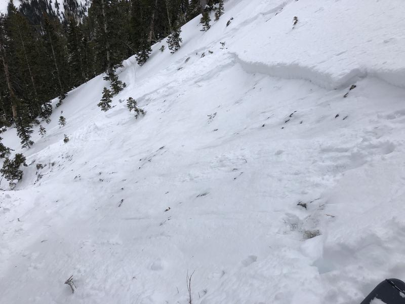
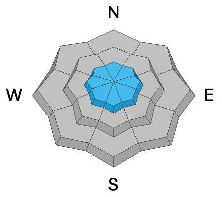
Saturday's Days Draw avalanche was a reminder that this problem still exists on very isolated slopes at the upper elevations, facing primarily north and northeast, but I also am suspicious about east as well. On slopes where the snowpack is deep (3-4'), this weak layer has adjusted to the load and the slab on top is strong. However, in thinner snowpack areas (1-3') this layer is still weak. The average depth of the Days Draw avalanche was 12-24".
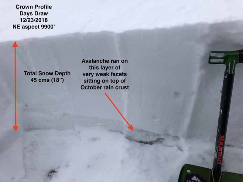
There are two reasons some slopes have a thinner snowpack: they avalanched previously (known as "repeaters") or they are in areas that have received less snow this month. The slope in Days Draw appeared to have been a repeater from late November. The photo below shows the snowpack structure of the crown on the Days Draw avalanche, where the very weak layer of faceted snow down near the ground is clearly visible.
When I visited the Days Draw avalanche yesterday, I was expecting to find the northeast facing slope wind-loaded from recent westerly winds. But there was no wind loading. Other slopes that have this poor structure on a thin snowpack have likely been wind-loaded, adding additional stress to the weak layers below, and are just waiting for the unexpecting rider to hit the sweet spot.
What to do? There were many tracks on the slopes adjacent to the Days Draw avalanche, so tracks are not an indication of stability. However we do know this weak structure exists on slopes with a snowpack less than about 3' deep on slopes facing north through northeast above about 9500'. Avoid these slopes and you avoid the problem. In addition to repeater slopes in the core Cottonwoods zone, other areas where I am suspicious you may find this weak structure include the Park City ridgeline and Millcreek Canyon.
General Announcements
This information does not apply to developed ski areas or highways where avalanche control is normally done. This forecast is from the U.S.D.A. Forest Service, which is solely responsible for its content. This forecast describes general avalanche conditions and local variations always occur.