Forecast for the Salt Lake Area Mountains

Trent Meisenheimer
Issued by Trent Meisenheimer on
Friday morning, December 21, 2018
The avalanche danger is LOW and the snowpack is mostly stable. But low danger doesn’t mean no danger - avalanches can be triggered on isolated terrain features. The most likely slopes would be those facing north through easterly at the upper elevations, or any steep slope with a recent drift of wind blown snow.
Travel one at a time in steep terrain, keep your partner in sight, and be in position to get to them quickly should there be an avalanche.
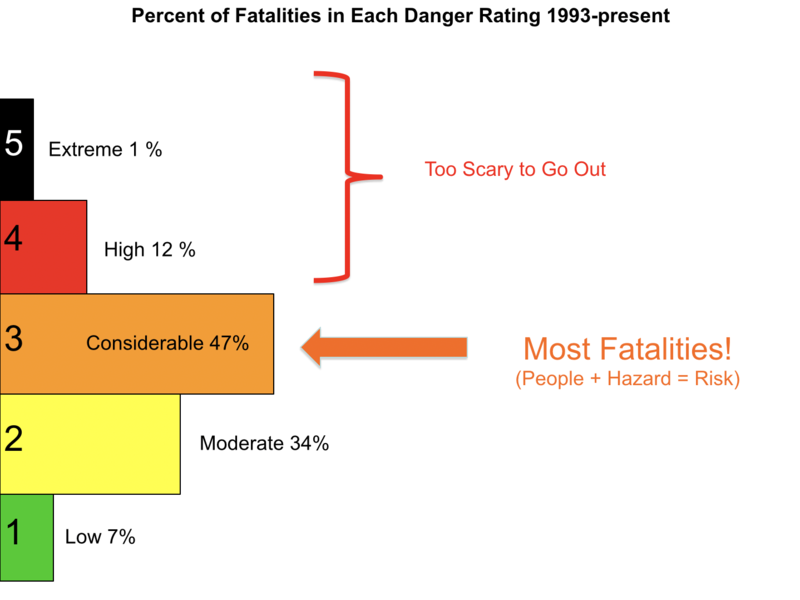
Low
Moderate
Considerable
High
Extreme
Learn how to read the forecast here
Special Announcements
The new UAC IOS mobile app is now available on the app store. Check out the new "My Weather" feature.

Check out the new free online avalanche course series developed by the Utah Avalanche Center. This is a great way to refresh your skills or prepare you for a Backcountry 101 or Level 1 class.
Weather and Snow
Under west-south-west flow this morning we will see increasing clouds, ushered in from the west, along with a few inches inches of new snow possible before clearing out this afternoon. Fortunately, there is a progressive pattern setting up as a series of storms cross northern Utah over the next week. The first in the series is a fast moving shortwave that will be here late this evening and could bring 2-4" of new snow before clearing out by Saturday morning. A short and brief period of high pressure over the weekend before a more organized and better looking storm slated for Christmas day.
Westerly winds have increased and are currently blowing 15-20 mph gusting into the mid 20's across the upper elevations. Mid elevation anemometers are spinning 10-15 mph gusting into the low 20's. Current temperatures are in the low 30's °F at 10,000'.
The snow surface over the past week has taken a beating from the wind and sun. However, Wednesday's angry two inches of graupel along with the wind helped to smooth the snow surface and save the day. It's not over the head and over the hood, but, there remains soft, spongy turns and many backcountry travelers reported good riding and turning conditions in the backcountry. Southerly facing terrain will be crusted.
Recent Avalanches
No new avalanches reported yesterday. Here is a list of all recent observations: HERE
Every week Greg Gagne puts together a recap of the recent events over the past week called the "Week in Review" it's a great resource to catch up on current events or to simply look at the trend over the past week. You can find it HERE.
Ad
Avalanche Problem #1
Normal Caution
Type
Location
Likelihood
Size
Description
Wind Drifted Snow: With this morning's bump in westerly winds along with a few inches of new snow you can expect to find fresh drifts of wind blown snow along the ridges. Be on the lookout and avoid pillowy, rounded, and hollow sounding snow. Wind drifted snow will likely be on the lee sides of ridge crests and around terrain features, like gully walls, sub ridges and down into open bowls. They should be easy to spot and easy to avoid.
Persistent Weak Layer: Poor snowpack structure remains on shady mid and upper elevation slopes. While this has not produced avalanches in the backcountry for 12 days, it’s hard to completely trust the layering of a stronger slab over a weak and faceted layer. Steep, rocky north and northeast facing terrain with fresh drifts of wind blown snow is particularly suspect.
Photo: Is from our "Know Before You Go" presentations. It shows that 7% of fatalities happen at LOW danger. Keep that in mind of you're getting after avalanche terrain today.
General Announcements
This information does not apply to developed ski areas or highways where avalanche control is normally done. This forecast is from the U.S.D.A. Forest Service, which is solely responsible for its content. This forecast describes general avalanche conditions and local variations always occur.