Forecast for the Provo Area Mountains

Nikki Champion
Issued by Nikki Champion on
Saturday morning, April 12, 2025
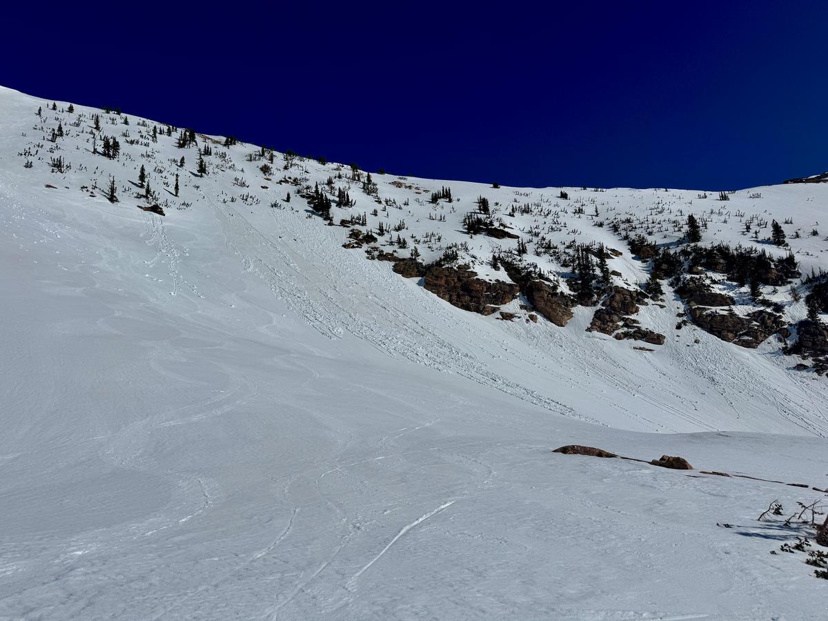
Avalanche danger is LOW this morning but will quickly rise to MODERATE with daytime heating. Wet loose avalanches, and possibly isolated wet slabs, will become more likely on sun-exposed slopes facing west through north through east, as well as on lower and mid-elevation northerly aspects. This is a timing issue: as the snow softens, instability increases. Travel early, watch for signs of warming, and avoid steep slopes once the surface becomes wet and unsupportable.
Cornices may collapse naturally and could trigger avalanches on the slopes below. Roof avalanches remain a hazard in mountain communities—keep people and pets clear of steep, snow-loaded roofs.
Be prepared to adjust your tour plan based on real-time conditions and observations in the field.
Portions of the danger rose colored gray indicate little to no snow.
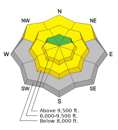
Low
Moderate
Considerable
High
Extreme
Learn how to read the forecast here
Special Announcements
Motorized Users—Please consider taking this 5-minute survey to help researchers better understand avalanche education participation and safety preparedness. Responses are anonymous and confidential.

Our regular daily avalanche forecasts will end this Sunday, April 13. After that, we will issue updates when necessary and publish public observations until May 1.
Weather and Snow
This morning, skies are partly cloudy with temperatures in the low to mid-50s °F. Winds are gusting up to 40 mph on upper-elevation ridgelines, with the highest peaks seeing gusts near 60 mph.
Today, expect mostly sunny and very warm conditions, with upper-elevation highs in the mid-60s °F and even warmer temperatures below. Winds from the west-southwest will remain elevated ahead of a dry cold front, averaging 10–20 mph with gusts to 30 mph near ridgelines and up to 60 mph on the highest peaks. The front is expected around midday, after which winds will shift west and gradually taper through the afternoon. Moisture behind the front could bring scattered showers this evening and overnight.
Despite warm overnight temps, the elevated winds likely provided a superficial refreeze this morning. Stronger winds may help keep the surface cooler, but increased cloud cover could trap heat and shorten the window for supportable snow.
Recent Avalanches
No new avalanches reported in the Provo area.
See the recent avalanche list HERE.
Ad
Avalanche Problem #1
Wet Snow
Type
Location
Likelihood
Size
Description
The April sun is strong, and we’ve had several nights without a solid refreeze. Regardless of wind, expect wet loose avalanches, and sloppy, unsupportable snow on east, south, and west aspects—as well as lower and mid-elevation north-facing slopes.
Larger wet slab avalanches are becoming more likely with each day of warm temperatures. There are still a few layers in the snowpack where water can pool, increasing the potential for deeper, more destructive avalanches—even if the exact timing is hard to pin down.
Cornices may break naturally and trigger slides below. Roof avalanches—where a roof sheds its snowpack—remain a serious objective hazard in mountain communities. Never let children play beneath steep, snow-loaded roofs. A fatal roof avalanche occurred as recently as April 2023 in Brighton Township, where an adult was likely working beneath a roof when it slid.
Bottom line: Get out early and get home early. When the snow turns wet and unsupportable, it’s time to change aspects or call it a day. Rollerballs, wet sluffs, and collapsing cornices are all signs that things are heating up. Even small slides can be dangerous in steep terrain, so plan your exits and stay alert.
Example of wet snow from American Fork - D. Kelly
General Announcements
This information does not apply to developed ski areas or highways where avalanche control is normally done. This forecast is from the U.S.D.A. Forest Service, which is solely responsible for its content. This forecast describes general avalanche conditions and local variations always occur.