Forecast for the Ogden Area Mountains

Trent Meisenheimer
Issued by Trent Meisenheimer on
Saturday morning, February 22, 2025
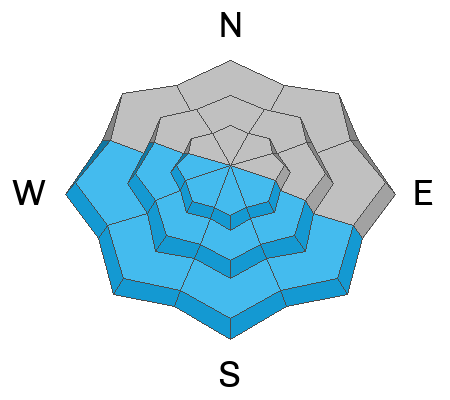
The avalanche danger is MODERATE on slopes at the mid and upper elevations northwest through east-facing terrain. Here, slab avalanches may break down several feet deep into weaker layers in the snowpack. We also have a MODERATE avalanche danger for soft slabs failing within the new snow. Evaluate the snow and terrain carefully and continue to practice safe travel protocols.

Wet-loose avalanches on steep, southerly-facing slopes are possible with daytime heating and direct sun.
Low
Moderate
Considerable
High
Extreme
Learn how to read the forecast here
Special Avalanche Bulletin
The Utah Avalanche Center is issuing a Special Avalanche Bulletin after a series of storms in the last week has left a thick blanket of snow at all elevations, creating excellent powder riding conditions while also elevating the backcountry avalanche danger. Don't let the fresh snow and sunshine influence your decision-making - avalanche conditions remain dangerous, and careful snowpack and terrain analysis are required for backcountry travel. Fortunately, there are great riding and travel conditions away from avalanche terrain on slopes less than 30° in steepness.
Weather and Snow
Under mostly clear skies, the mountain temperatures range from 13-23 °F. The wind is relatively calm across most terrain, blowing 5-15 mph from the west.
Today, we expect increasing cloud cover and temperatures rising into the upper 20s to low 30s °F. The wind is forecast to stay about the same, blowing 5-15 mph across most upper elevations.
Riding and turning conditions are as good as they get... for this year anyway. Yesterday, the sun came out and this morning you will find a zipper crust on most south through west-facing terrain. Soft-settled powder exists on many of the shady aspects.
Extended snow forecast: Not good!
Recent Avalanches
No new avalanches were reported yesterday.
Ad
Avalanche Problem #1
Persistent Weak Layer
Type
Location
Likelihood
Size
Description
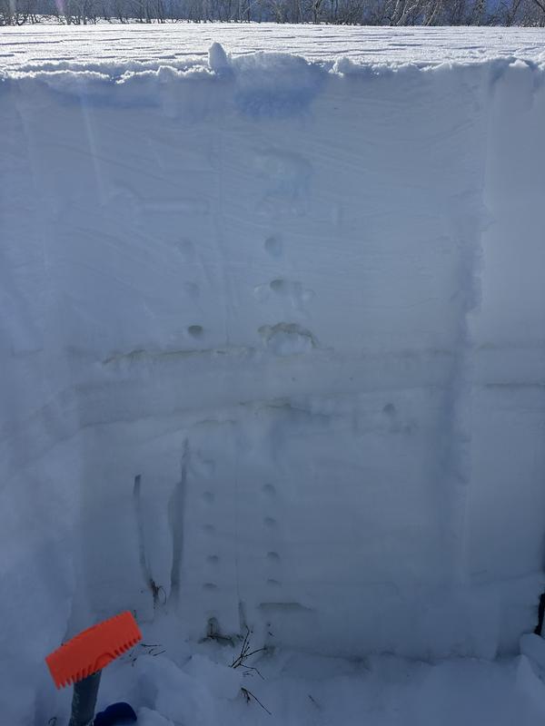
There are several weak layers in the top 1-3 feet of the snowpack, including layers of faceted snow around temperature crusts. Richie Schumacher's photo below shows some of the crusts that can be found on all aspects.
If you choose to approach avalanche terrain you are going to have to continually evaluate the snowpack by pulling out your shovel and looking for weak layers in the snowpack. A widespread spatial variability complicates things, meaning the lack of a weak layer on one slope doesn't imply the lack of a weak layer on an adjacent slope. If you aren't confident in doing this necessary work of evaluating the snowpack, there is a easy solution: avoid avalanche terrain and enjoy the excellent riding conditions on low-angled slopes.
Avalanche Problem #2
New Snow
Type
Location
Likelihood
Size
Description
You may find sensitive soft slabs failing within the new snow. Perform shovel tilt tests and use slope cuts to see how the new snow is stabilizing. Also, watch for pockets of wind-drifted snow across the upper elevations.
Avalanche Problem #3
Wet Snow
Type
Location
Likelihood
Size
Description
It's closer to March than February. The sun is strong this time of year and it doesn't take much to turn cold snow into damp/wet snow. Be on the lookout for signs of wet snow avalanches. If you're seeing roller balls it's time to change to a cooler aspect. When I hear in the forecast that we could have mid to high-level clouds, "green housing" starts to come to mind. Be on the lookout for snow on the shady aspects also becoming wet or damp with daytime heating.
General Announcements
This information does not apply to developed ski areas or highways where avalanche control is normally done. This forecast is from the U.S.D.A. Forest Service, which is solely responsible for its content. This forecast describes general avalanche conditions and local variations always occur.