


Nikki Champion
Forecaster
Week in Review: Avalanche Conditions and Snowpack Developments (February 14 - February 20, 2025)
Each week, we look back at the key snowfall, weather, and avalanche events from the previous week. For archived forecasts, visit the Salt Lake Mountains’ past updates.
Overall Summary:
It was an intense week in the mountains, with a series of storms bringing heavy snowfall, strong winds, and rapidly evolving avalanche conditions.
It was an intense week in the mountains, with a series of storms bringing heavy snowfall, strong winds, and rapidly evolving avalanche conditions.
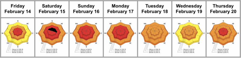
The week kicked off with an Avalanche Warning on Friday as a storm moved in, pushing avalanche danger to HIGH at upper elevations. By Saturday, EXTREME danger developed on north-facing upper-elevation terrain, triggering a natural avalanche cycle. Multiple storms stacked up feet of snow, and by Sunday, over 30 backcountry avalanches had been reported—many occurring outside the usual aspects and elevations, including solar aspects and some lower elevations. See all recent avalanches HERE.
With avalanches rolling in across the range, it became hard to track which of the four different persistent weak layers was failing. These were unusual conditions, raising alarm bells heading into the rest of the week. None of the forecasters trusted the snowpack, and even as avalanche danger gradually dropped, the travel advice remained the same: travel in avalanche terrain not advised.
By Monday, the Avalanche Warning was lifted, but HIGH danger remained. Forecasters confirmed four separate persistent weak layers, increasing uncertainty and hazard, even on less typical avalanche terrain. By midweek, the danger settled at CONSIDERABLE but remained widespread. Close calls underscored the instability—one skier grabbed a tree after being carried in Mill A Basin, while a snowboarder was caught and carried near Lackawaxen Lake.
By Thursday, another storm arrived, pushing avalanche danger back to HIGH. Heavy snowfall, strong winds, and an already fragile snowpack meant avalanches were once again likely to be large and destructive. With buried weak layers, wind slabs, and continued loading, the stage was set for another high-consequence weekend in the backcountry.
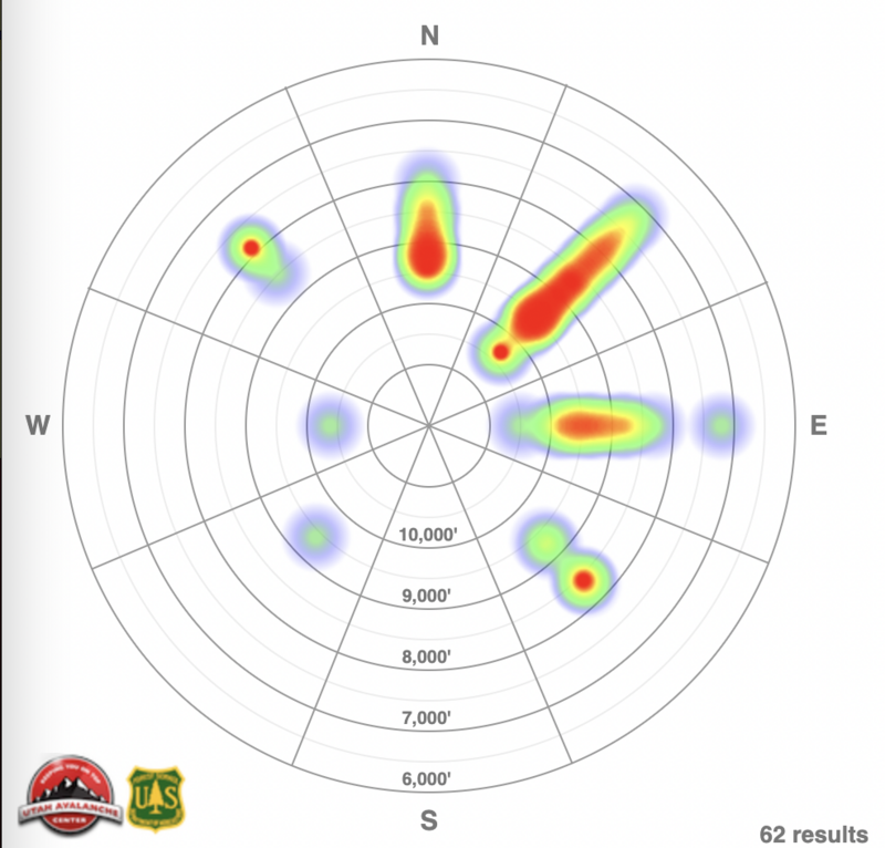
Avalanche heat map for the Salt Lake area mountains for Feb 13-Feb 20
Friday, February 14
With a storm rolling in, an Avalanche Warning went into effect. Avalanche danger was HIGH at upper elevations, CONSIDERABLE at mid-elevations, and MODERATE lower down. Natural avalanches had already occurred, and human-triggered slides were very likely, especially on northerly-facing slopes, as heavy snowfall and strong winds added more load.
With a storm rolling in, an Avalanche Warning went into effect. Avalanche danger was HIGH at upper elevations, CONSIDERABLE at mid-elevations, and MODERATE lower down. Natural avalanches had already occurred, and human-triggered slides were very likely, especially on northerly-facing slopes, as heavy snowfall and strong winds added more load.
A winter storm warning called for 5–10 inches of new snow by sunset, with strong southwest winds gusting 30–60 mph. A northwest flow followed, delivering heavier snowfall through Saturday, with another storm on Sunday. Fourteen backcountry avalanches were reported, and ski areas and highways saw dozens more. Most ran on weak facets and new/old snow interfaces. Avalanche danger was climbing.
Saturday, February 15
The Avalanche Warning remained in place as EXTREME danger developed on upper-elevation north-facing terrain, with HIGH danger at mid-elevations and CONSIDERABLE danger elsewhere. Natural avalanches were certain, and human-triggered slides were very likely.
The Avalanche Warning remained in place as EXTREME danger developed on upper-elevation north-facing terrain, with HIGH danger at mid-elevations and CONSIDERABLE danger elsewhere. Natural avalanches were certain, and human-triggered slides were very likely.
A powerful storm dropped 15–33 inches of snow (1.25–3 inches of water) while strong northwest winds gusted 50–70+ mph. Snowfall continued throughout the day, adding another 4–7 inches.
Over 20 backcountry avalanches were reported to the Utah Avalanche Center, including a second-hand report of a rider caught and carried in Summit Park and a partial burial outside Brighton’s boundary in Hidden Canyon. Ski areas and highway operations observed a widespread natural avalanche cycle early in the morning, with many slides triggered remotely or unintentionally. Many of these failed on a suspect crust interface, some with an even solar tilt.
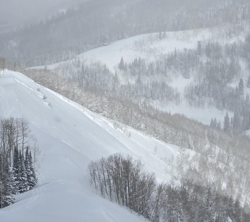
Large remotely triggered avalanche on Reynolds Peak - slope with an eastern, almost southeastern tilt.
Sunday, February 16
Avalanche danger remained HIGH at mid and upper elevations, with CONSIDERABLE danger at lower elevations. The avalanche warning stayed in effect, and both natural and human-triggered avalanches were very likely.
Avalanche danger remained HIGH at mid and upper elevations, with CONSIDERABLE danger at lower elevations. The avalanche warning stayed in effect, and both natural and human-triggered avalanches were very likely.
A powerful storm had delivered 17–35 inches of snow (1.5–3.7 inches of water), and strong winds had created widespread instability. Wind-drifted snow and multiple buried weak layers meant avalanches were likely to be large and destructive. By the end of the weekend, over 30 backcountry avalanches had been reported.
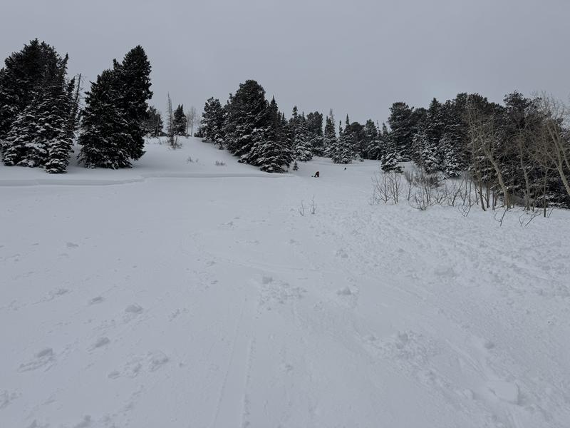
Another large on Circle Awl - remotely triggered - southeastern aspect
Monday, February 17
After multiple days, the avalanche warning was finally lifted, but avalanche danger remained HIGH at mid and upper elevations. The snowpack was becoming more complex, with four separate persistent weak layers identified—any of which could produce avalanches, even on less typical aspects like solar slopes.
After multiple days, the avalanche warning was finally lifted, but avalanche danger remained HIGH at mid and upper elevations. The snowpack was becoming more complex, with four separate persistent weak layers identified—any of which could produce avalanches, even on less typical aspects like solar slopes.
By this point, the mountains had picked up 20–45 inches of snow (2.00–4.79 inches of water), and strong northwest winds had built dangerous wind slabs. Another 5–10 inches had fallen in the past 24 hours, with gusts up to 40 mph.
A close call occurred in Mill A Basin when a skier triggered a large avalanche. They managed to grab a tree as the snow rushed past. The avalanche broke 2 feet deep, 500 feet wide, and ran 800 vertical feet.
Close call in Mill A- Northeastern aspect
Tuesday, February 18
Avalanche danger remained CONSIDERABLE across all elevations and aspects, with human-triggered avalanches likely, especially on slopes harboring buried weak layers.
Avalanche danger remained CONSIDERABLE across all elevations and aspects, with human-triggered avalanches likely, especially on slopes harboring buried weak layers.
Another close call occurred near Lackawaxen Lake when a snowboarder was caught and carried after dropping a cliff on a northeast-facing slope at 10,300 feet. The avalanche released below the cliff, breaking 2 feet deep and 60 feet wide. The rider was carried 175 feet, while the full avalanche ran closer to 350 feet.
Wednesday, February 19
Avalanche danger remained CONSIDERABLE at mid and upper elevations, with human-triggered avalanches likely due to multiple buried weak layers and wind-drifted snow. MODERATE danger persisted at lower elevations, where avalanches were still possible. Instability decreased, but another incoming storm was expected to push danger back up. Avoiding avalanche terrain remained the best choice.
Avalanche danger remained CONSIDERABLE at mid and upper elevations, with human-triggered avalanches likely due to multiple buried weak layers and wind-drifted snow. MODERATE danger persisted at lower elevations, where avalanches were still possible. Instability decreased, but another incoming storm was expected to push danger back up. Avoiding avalanche terrain remained the best choice.
The snowpack remained highly variable, with four buried weak layers. Stability tests continued to show inconsistent results—even on similar aspects—highlighting how complex conditions remained. Wind-drifted slabs were still sensitive at mid and upper elevations, and large cornices were forming.
Recent avalanche activity included a skier-triggered slide that ran 1,500 feet and stepped down into deeper weak layers. Ski resorts continued to report stubborn wind and storm slabs during control work.
Another storm was on track for Thursday–Friday.
Thursday, February 20
Avalanche danger started at CONSIDERABLE in the morning but was expected to rise to HIGH by the afternoon as heavy snowfall and strong winds built unstable conditions. By then, natural avalanches would become likely, and human-triggered avalanches very likely. The snowpack continues to be challenging and outside the normal for this time of year in the Central Wasatch, with multiple buried weak layers, meaning any avalanche could step down into deeper layers, creating large and destructive slides.
Avalanche danger started at CONSIDERABLE in the morning but was expected to rise to HIGH by the afternoon as heavy snowfall and strong winds built unstable conditions. By then, natural avalanches would become likely, and human-triggered avalanches very likely. The snowpack continues to be challenging and outside the normal for this time of year in the Central Wasatch, with multiple buried weak layers, meaning any avalanche could step down into deeper layers, creating large and destructive slides.
The storm arrived later than expected, with 4 inches of snow reported early in the morning. The heaviest snowfall was forecast between 7 AM and 2 PM, with snowfall rates up to 2 inches per hour, expected to bring a total of 9–16 inches by the end of the day. Winds had howled overnight, with ridgetop gusts over 80 mph. While they had eased slightly, they remained strong enough to transport snow and build dangerous wind slabs. Temperatures hovered in the mid-20s, with colder air moving in.
Leave a comment