Forecast for the Logan Area Mountains

Paige Pagnucco
Issued by Paige Pagnucco on
Sunday morning, February 16, 2025
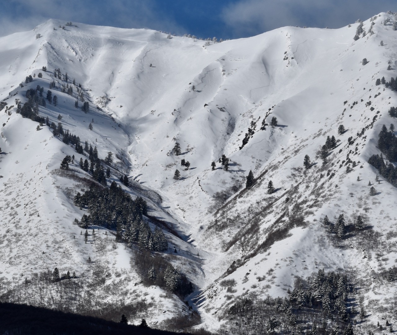
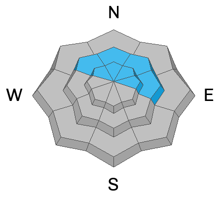
The avalanche danger is HIGH on upper-elevation slopes. Heavy snowfall and drifting by strong winds have created very dangerous avalanche conditions, and natural and human-triggered avalanches are very likely on slopes steeper than 30°. You'll find CONSIDERABLE danger in mid-elevation terrain where human-triggered avalanches are likely. A MODERATE danger exists at low elevations, where human-triggered avalanches are possible.
  • People should avoid travel in avalanche terrain and avoid avalanche runouts, especially in and below upper-elevation terrain.
  • The avalanche danger is complex; safe terrain choices are your best bet today.
  • You'll find excellent deep powder riding conditions in low-angle terrain and meadows.
Low
Moderate
Considerable
High
Extreme
Learn how to read the forecast here
Weather and Snow
The Logan area mountains have picked up 3.3" of snow water equivalent in the past 72 hours. While we all love to see a big, long-lasting winter storm, the added weight to the snowpack has made navigating avalanche danger very difficult. The Wellsvilles fell apart, possibly overnight or early Saturday morning, and with some clearing, we observed numerous very large slab avalanches that ran 2000'+, with one hitting Maple Bench (photo below). These are unsurvivable. A few weak layers are underlying the new snow, and it's impossible to know which one will fail when stressed enough. Though the danger is no longer HIGH at mid and low elevations, I am not taking that as a license to jump onto just any slope today. In fact, most avalanche fatalities occur when the danger is CONSIDERABLE. We have a complicated hazard today, so the best strategy is to stay on slopes less than 30 degrees and out from under steeper terrain. Any weight added today from snow and wind will only preserve or increase the danger.

-The Tony Grove Snotel at 8400 feet reports 3 inches of new snow with .3" SWE in the last 24 hours and 3.3" SWE in the past 72 hours. It's 19° F, with 90 inches of total snow. The Card Canyon weather station at 8800 feet reports 2 inches of new snow. It's 16° F, with 64 inches of total snow.
Winds on Logan Peak are blowing 25-30 MPH from the west-southwest with a recent gust of 45 MPH. It's 12°F. At 9500 feet, Paris Peak is also 11° F, with winds blowing 22 to 31 mph from the southwest.

The National Weather Service has issued a Winter Weather Advisory from noon today through noon Tuesday. Expect heavy snowfall at times this afternoon, with gusty winds blowing from the west-southwest and an 8500' high of 27°F. The mountains could pick up another 3-9". The storm continues tonight and through tomorrow, with more snow and wind for the Monday holiday. Unsettled weather lasts through the work week.

Thank you for reading our forecasts before heading out into the backcountry - we've had four avalanche fatalities this season and do not want anyone else to die in an avalanche.

For more information, visit the UAC weather page here: Weather - Utah Avalanche Center
For Logan-specific weather, go here: Logan Mountain Weather - Utah Avalanche Center
Recent Avalanches
Yesterday, we received many reports of natural and human-triggered small to medium-sized soft slab avalanches. We observed numerous very large natural avalanches in the Wellsvilles, which likely occurred overnight Friday or early Saturday morning. Some of these were interconnected and ran over 2000', hitting Maple Bench. Photo of Bird Canyon avalanches.
Read about all avalanches and observations in the Logan Zone HERE.
***Remember, the information you share about avalanches you see or trigger in the backcountry could save lives.
Ad
Avalanche Problem #1
New Snow
Type
Location
Likelihood
Size
Description
AVOID TRAVEL IN ALL AVALANCHE TERRAIN AT UPPER ELEVATIONS AND BELOW UPPER ELEVATION RUNOUT ZONES
Soft slab and loose avalanches of storm snow are very likely on steep slopes in upper and mid-elevation terrain. People are very likely to trigger avalanches on slopes steeper than about 30°, and avalanches could be triggered remotely (from a distance) or from below steep slopes. Copious amounts of new snow blanket the range and, having landed on top of multiple weak layers, it's hard to know which slopes are the most tenuous. Your best strategy today is to stick with low-angle terrain and meadows not connected to steeper terrain.
Avalanche Problem #2
Wind Drifted Snow
Type
Location
Likelihood
Size
Description
Wind slab avalanches, consisting of drifted storm snow, are likely in wind exposed terrain on upper and mid-elevation slopes. Natural cornice falls and large wind slab avalanches are likely as tremendous amounts of fresh snow has loaded into avalanche starting zones. Wind slabs are most likely found on the lee side of major ridges and corniced slopes facing northwest through southeast, with the majority facing the east half of the compass. Slabs of wind-drifted snow are also found in and around terrain features like sub-ridges, gullies, scoops, and cliff bands. Watch for cracking, a sure sign of instability.
Avalanche Problem #3
Persistent Weak Layer
Type
Location
Likelihood
Size
Description
Large and dangerous avalanches stepping down into older snow on one of several buried persistent weak layers are likely, especially in areas with shallower snow and poor snow structure. Audible collapses (whumpfs) and shooting cracks are sure signs of instability, but these may not be present when avalanches occur. Avalanches failing on a buried persistent weak layer might be triggered remotely (from a distance) or from below steep slopes.
Additional Information
On Saturday, February 8, a skier was killed by an avalanche in the Salt Lake Area Mountains. Photo below. We have completed our report and our hearts go out to the family, friends, and all who are affected by this tragic accident.
General Announcements
-National Forest Winter Recreation Travel Maps show where it's open to ride: UWCNF Logan, Ogden LRD Tony Grove, Franklin Basin CTNF Montpelier
-For all questions on forecasts, education, Know Before You Go, events, online purchases, or fundraising, call 801-365-5522.
-Remember the information you provide could save lives, especially if you see or trigger an avalanche. To report an avalanche or submit an observation from the backcountry, go HERE.
-Receive forecast region-specific text message alerts to receive messages about changing avalanche conditions, watches, and warnings. Sign up and update your preferences HERE.

This forecast is from the U.S.D.A. Forest Service, which is solely responsible for its content. This forecast describes general avalanche conditions, and local variations always occur.