Forecast for the Logan Area Mountains

Toby Weed
Issued by Toby Weed on
Thursday morning, February 13, 2025
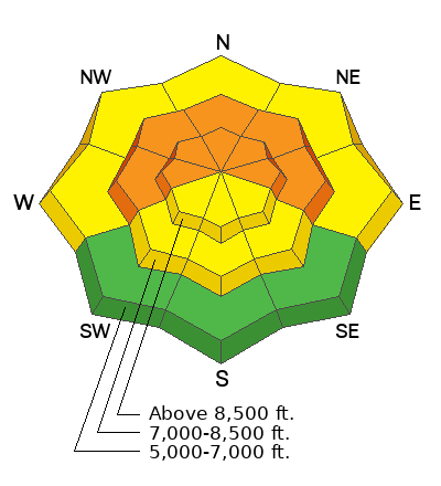
Heightened avalanche conditions exist this morning, and human-triggered avalanches are possible on previously drifted slopes where a persistent weak layer is buried 1 to 3 feet deep. Drifting by increasing winds from the south and heavy snowfall will elevate the danger on many slopes to CONSIDERABLE by this evening.
  • Careful snowpack evaluation, cautious route-finding, and conservative decision-making are essential.
  • Avoid travel on or under steep drifted slopes and ridge-top cornices.
Low
Moderate
Considerable
High
Extreme
Learn how to read the forecast here
Avalanche Watch
The avalanche danger is expected to rise to HIGH overnight and into Friday. Very dangerous avalanche conditions will develop tonight and last through the weekend.
Expected heavy snowfall and strong winds will lead to widespread and very dangerous avalanche conditions. Both human-triggered and natural avalanches are likely. Stay off of and out from under slopes steeper than 30 degrees.
Weather and Snow
The avalanche danger will rise today as a powerful winter storm, an "inland penetrating atmospheric river event" starts to impact the Logan Zone. Drifting by increasing winds from the south and intensifying snowfall will rapidly create dangerous avalanche conditions. Depending a bit on the timing of the onset of the snow, the danger will rise to CONSIDERABLE this afternoon or tonight. Very dangerous conditions will likely develop overnight, with significant natural avalanche activity quite possible.
We found very nice shallow (recrystallized) powder on all aspects in the Garden City/Swan Flats area yesterday. A future weak layer of near surface facets and graupel is widespread, and it caps a very hard melt/freeze crust in most areas. This is particularly a concern on most snow-covered slopes at lower and mid elevations, where the recrystallized powder capping the dusty crust is shallow and will likely become a thin persistent weak layer. The widespread hard crust from the early February warm spell will likely be a bed surface for future avalanches.
The biggest concern for today though, is triggering an avalanche that fails on a buried, persistent, weak layer lurking below the crust. While the problem is not widespread, the easiest way to avoid it is to stick to slopes less than 30°. Suspect areas where a person might trigger an avalanche failing on a persistent weak layer include outlying terrain with generally shallow and weak snow cover.

-The Tony Grove Snotel at 8400 feet reports an inch of new snow from yesterday. It's 4° F, with 71 inches of total snow. At the Card Canyon weather station at 8800 feet also reports an inch of new snow. It's 9° F, and there is 53 inches of total snow.
-Wind increased overnight at the CSI Logan Peak weather station at 9700 feet, and are now blowing from the south 37 mph with gusts to 46 mph. It's 6° F, and the wind chill is -20° F. On Paris Peak, at 9500 feet, it is 2° F, and the winds are blowing 16 to 29 mph from the south-southwest creating a -20° F wind chill value.

The National Weather Service has issued a Winter Storm Warning, beginning today and extending through Saturday evening. The Logan area mountains could pick up 1-3 feet of snow, (16 to 25 inches by tomorrow morning.) Winds blowing from the south 10 to 15 mph this morning will increase significantly this afternoon to 18 to 25 mph and gusts around 40 mph. Expect rising avalanche danger today and overnight, extending into the long holiday weekend. Please read our forecasts before heading out into the backcountry - we've had four avalanche fatalities this season and do not want another.

For more information, visit the UAC weather page here: Weather - Utah Avalanche Center
For Logan-specific weather, go here: Logan Mountain Weather - Utah Avalanche Center
Recent Avalanches
No new avalanches were reported this week. Read about all avalanches and observations in the Logan Zone HERE.
***Remember, the information you share about avalanches you see or trigger in the backcountry could save lives.
Ad
Avalanche Problem #1
Persistent Weak Layer
Type
Location
Likelihood
Size
Description
In late January, the Logan area mountains developed a widespread layer of weak and sugary surface snow. Wind drifting and recent accumulations have built thick slabs on top of this layer, and now, many slopes are plagued by a persistent weak layer buried 1 to 3 feet deep. Today, people could trigger dangerous hard slab avalanches failing on this persistent weak layer in upper-elevation terrain. You will need to take out your shovel and dig to find and assess the buried persistent weak layer.
  • Avalanches failing on a buried persistent weak layer might be triggered remotely (from a distance) or from below.
  • Audible collapses (whumpfs) and shooting cracks are sure signs of instability, but these may not be present when avalanches occur.
  • The best way to avoid this problem is to avoid steep slopes with poor snowpack structure.
  • Excellent powder riding can be found in the meadows and on slopes less steep than 30°.
Avalanche Problem #2
Wind Drifted Snow
Type
Location
Likelihood
Size
Description
We advise staying clear of all steep, wind-drifted slopes. Today, soft freshly formed wind slabs and harder wind slab avalanches failing on a buried persistent weak layer are possible for people to trigger. Today's south wind will build drifts and wind slabs in lee terrain, increasing the danger on west, north, and east-facing slopes. But, wind slabs may also form in and around terrain features on windward slopes due to terrain influences on drifting.
  • Wind slabs are most likely to be found on the lee side of major ridges and corniced slopes facing northwest through southeast. They were also formed (and will build today) by cross-loading in and around terrain features like sub-ridges, gullies, and cliff bands.
  • Soft, freshly formed wind slabs can be very sensitive, possibly even remotely triggered. Hard wind slabs sometimes allow a person to get well out on them before suddenly releasing.
Additional Information
Recently, we’ve been asked why there have been so many avalanche fatalities this season, and the answer is simple– faceted snow. Over the past two seasons, we experienced a deep snowpack that eventually buried any faceted snow too deeply for it to be a major concern. This winter, however, is different. Currently, the snow-water equivalent statewide is at 78% of normal, and our snowpack remains relatively shallow. The faceted snow has continued to pose a significant risk in areas with shallow snow since just after Christmas, with some slopes avalanching multiple times on the same weak layer. The situation becomes more complex, adding wind loading and the variability of snowfall accumulation. Some slopes may be safer, while others are on the edge, waiting for a trigger (you) to hit the weak spot. After two seasons of riding just about any line we wanted, this year demands a more cautious approach. We must be more conservative in our terrain choices, saving the more consequential terrain for another time or season. Terrain is one factor we can control, and the easiest way to avoid issues with persistent weak layers like facets is to stay off slopes steeper than 30 degrees. Read more about the persistent weak layer problem HERE.
The final accident report for last week's fatal Monte Cristo avalanche is HERE.
Our deepest condolences go out to Scott's family and friends and all who are affected by this tragic accident.

On Saturday, February 8, a skier was killed by an avalanche in the Salt Lake Area Mountains. Photo below. We are gathering information and will publish our report soon. Preliminary report is HERE
General Announcements
-National Forest Winter Recreation Travel Maps show where it's open to ride: UWCNF Logan, Ogden LRD Tony Grove, Franklin Basin CTNF Montpelier
-For all questions on forecasts, education, Know Before You Go, events, online purchases, or fundraising, call 801-365-5522.
-Remember the information you provide could save lives, especially if you see or trigger an avalanche. To report an avalanche or submit an observation from the backcountry, go HERE.
-Receive forecast region-specific text message alerts to receive messages about changing avalanche conditions, watches, and warnings. Sign up and update your preferences HERE.

This forecast is from the U.S.D.A. Forest Service, which is solely responsible for its content. This forecast describes general avalanche conditions, and local variations always occur.