UDOT PLANNED AVALANCHE CLOSURES!!

Forecast for the Provo Area Mountains

Nikki Champion
Issued by Nikki Champion on
Wednesday morning, January 8, 2025
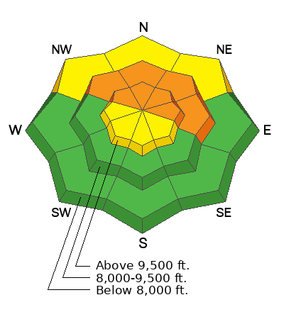
The avalanche danger is CONSIDERABLE at upper elevations and mid-elevation slopes facing northwest through north to east. Avalanches may be large and destructive, failing on a buried persistent weak layer 1–3+ feet deep, and potentially hundreds of feet wide. These avalanches can be triggered from a distance or below.

CONSIDERABLE means dangerous human-triggered avalanches are likely. Evaluate snow and terrain carefully, make conservative decisions, and avoid travel on or below slopes steeper than 30 degrees with poor snow structure. Lower-angled slopes offer good riding and travel conditions.
Low
Moderate
Considerable
High
Extreme
Learn how to read the forecast here
Special Announcements
Receive forecast region-specific text message alerts to receive messages about changing avalanche conditions, watches, and warnings. Sign up and update your preferences HERE.
Weather and Snow
This Morning, skies are clear, and a temperature inversion is in place, with trailhead temperatures hovering around 1°F and ridgetop temperatures in the low teens °F. Winds are shifting from east-northeasterly to more northwesterly and decreasing, reaching around 20 mph at the highest ridgetops.
Today, Temperatures will rise into the upper 20s and low 30s°F under mostly clear skies, with high clouds building this afternoon. Winds will increase, with northwesterly winds averaging 5 mph at mid-elevations and 15–30 mph on the highest ridgelines. Gusts at the highest peaks could reach up to 50 mph by late afternoon.
Overnight, little to no precipitation is expected, but strong, gusty northerly winds will accompany the storm this evening.
Outlook: Confidence is building in the incoming storm system this weekend. Water totals are expected to range from 0.25 inches to nearly 1 inch. Stay tuned for updates as we get closer.
Recent Avalanches
Overall, it was a relatively quiet day in the backcountry. No new avalanches were reported from the Provo area mountains. Just north of Provo, Ski patrols reported a 2–4' by 40' soft slab triggered by explosives.
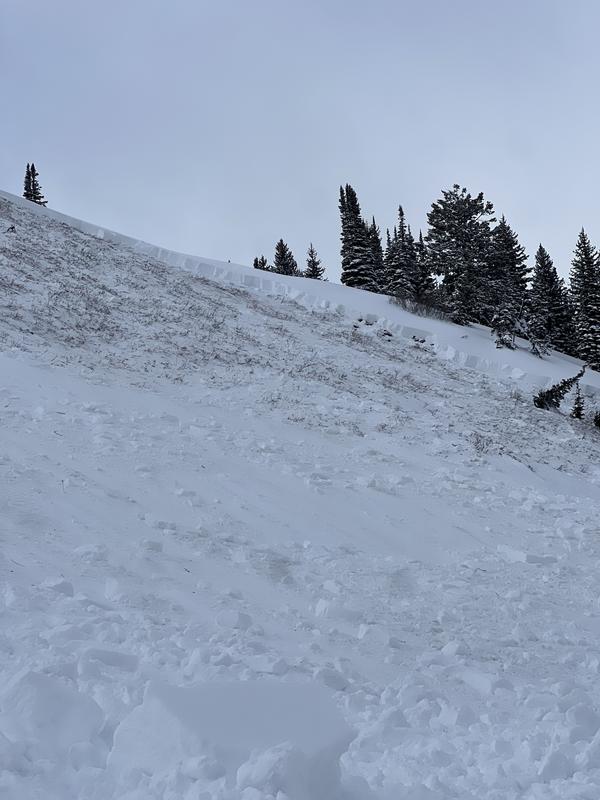
Yesterday, I made it down to Pole Line Pass and Ant Knolls. I was able to get a better look at the Ant Knolls avalanche from Sunday, a snowmobiler triggered an avalanche on a steep northeast-facing slope at 9300' and ripped to the ground. See photo below. Across the board we found weak faceted snow, and got a few collapses.

Forecasters were out in the field yesterday, covering terrain from Provo to Salt Lake and up to Ogden. Take a look at the recent observations and avalanche reports to get a clear picture of current conditions across the range.
Ad
Avalanche Problem #1
Persistent Weak Layer
Type
Location
Likelihood
Size
Description
The primary concern is triggering a large, unsurvivable hard slab avalanche on a persistent weak layer of faceted snow buried 1–3+ feet deep on mid- and upper-elevation slopes facing northwest through north to east. This weak layer formed early in the season and was primed by the Christmas storm, creating a more cohesive slab. It will take time for the snowpack to stabilize. While the likelihood of triggering one is gradually decreasing, the consequences remain just as high.
Though the likelihood and distribution align with a considerable danger, travel advice continues to trend higher. I’ll continue to avoid traveling on or under slopes steeper than 30° with this buried weak layer near the ground.

See the poor snowpack structure that can be seen across most of the Provo area Mounatins. A slab from Pole Line Pass sitting top on top of only 15-20 cm of facets. NE 8950.
Additional Information
The accident reports for the Porter Fork and Davenport Hill Accident have been completed. You can read them HERE.
At the Utah Avalanche Center, we strive to learn from every avalanche incident and share insights to help others avoid similar accidents. We have all experienced close calls and understand how easily mistakes can happen. Our goal with these reports is to provide valuable learning opportunities.
General Announcements
This information does not apply to developed ski areas or highways where avalanche control is normally done. This forecast is from the U.S.D.A. Forest Service, which is solely responsible for its content. This forecast describes general avalanche conditions and local variations always occur.