Forecast for the Provo Area Mountains

Drew Hardesty
Issued by Drew Hardesty on
Monday morning, April 8, 2024
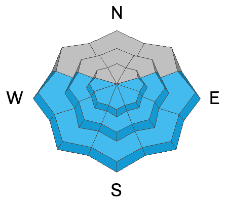
The Provo mountains have a mostly LOW avalanche danger this morning and the snow is generally stable. Remember that risk is inherent in mountain travel and even small avalanches can lead to trouble in extreme terrain.
The danger for wet avalanches will rise to MODERATE on all steep solar aspects. Cloud cover will be a wild card across the range - you'll need to watch how the snow is changing under your feet and adjust accordingly.
Low
Moderate
Considerable
High
Extreme
Learn how to read the forecast here
Weather and Snow
The weekend storm was a nice little refresh of 3-6" to smooth over the rough old snow surfaces.
Currently, skies are partly cloudy with light winds from the west northwest. Temperatures are in the upper teens to low 20s.
For today, we'll have partly cloudy skies. Winds will be light from the northwest. Mercifully, temperatures will slowly warm into the low to mid-20s up high, the low 30s down low.
The Outlook: slowly warming temperatures and a building ridge of high pressure for the week. Friday's mountain temps are expected to soar into the upper 40s to low 50s. The models suggest another storm for the late weekend into early next week...but a lot can change between now and then.
Recent Avalanches
While traveling along the Wasatch Back near the Ant Knolls, Dave and Chad saw one fresh wind-drifted snow avalanche on a north facing slope at 9300'. The avalanche had a small 8"-10" crown that was approximately 50' wide and ran 200' vertical feet.
Ad
Avalanche Problem #1
Normal Caution
Type
Location
Likelihood
Size
Description
If traveling into the alpine, you may find unstable snow on isolated terrain features. Shallow sluffs and pockets of soft slab may be left over from the weekend storm. Remember that even small avalanches may lead to trouble in extreme terrain.
Avalanche Problem #2
Wet Snow
Type
Location
Likelihood
Size
Description
Wet avalanches will be increasingly possible with periods of sun and slowly warming temperatures. I don't think things will get out of hand, but don't discount the April sun to trigger some wet and dry sluffs in the steepest terrain, at a minimum. If we see more sun than expected, you'll see all the tell-tale signs and pre-cursors of wet avalanches (pinwheels, rollerballs, etc) and you'll want to avoid being on or beneath steep sun-affected terrain.
General Announcements
This information does not apply to developed ski areas or highways where avalanche control is normally done. This forecast is from the U.S.D.A. Forest Service, which is solely responsible for its content. This forecast describes general avalanche conditions and local variations always occur.