Check out our Holiday Auction

Forecast for the Skyline Area Mountains

Brett Kobernik
Issued by Brett Kobernik on
Thursday morning, February 1, 2024
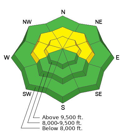
The overall avalanche danger is MODERATE on the Manti Skyline.
There is a small chance that a person could trigger an avalanche that breaks deep into weak snow near the ground.
The most dangerous areas are mid and upper elevation very steep slopes that face northwest, north and northeast.
Low
Moderate
Considerable
High
Extreme
Learn how to read the forecast here
Avalanche Watch
FOR THE MOUNTAINS OUTSIDE OF CEDAR CITY
What: The danger of avalanches is expected to increase Friday and Saturday as a winter snow storm adds snow to an existing weak snowpack.
When: In effect from 6 AM MST this morning to 6 AM MST Friday
Where: For the mountains of Southwestern Utah, including terrain around Brian Head ski resort and surrounding areas.
Impacts: Expected heavy snowfall coupled with very weak existing snow could produce dangerous avalanche conditions. Friday and Saturday are the most likely days for avalanches. An avalanche Warning will be issued Friday if expected snow accumulates tonight.
Warning Times: Thursday, February 1, 2024 - 6:45 AM to Friday, February 2, 2024 - 6:00 AM
Region: Southwest Utah
Weather and Snow
Current Conditions: Wednesday was slightly cooler and the wind from the south was just a little breezier than previous days. That said, it was still warm with temperatures well into the mid to upper 30s and light wind. With very little wind over the last week, you can still find quite nice soft snow in upper elevation northerly facing terrain. Overnight low temperatures were around 30˚F which is still pretty mild. Wind speeds increased just a bit more from the southwest. I'd call them light to moderate in speed. There are thin high clouds this morning.
Mountain Weather: We'll have increasing clouds today with the chance for snow late in the afternoon. Wind from the south southeast will increase at least into the moderate speed category today. Temperatures shouldn't get too much higher than the low 30s. The first half of this storm does not get me excited. The flow is too much from the south southeast. This is not favorable for "orographic lift" which is responsible for a majority of mountain snow accumulation. Below is an animation of orographic lifting.
The second half of the storm looks a bit better as the flow switches more from the southwest and then ultimately from the northwest. Overall, I think 4 to 8 inches of snow is reasonable by mid day Saturday. Perhaps a bit more if we're lucky. Another storm is shaping up for mid-week next week.
Ad
Avalanche Problem #1
Persistent Weak Layer
Type
Location
Likelihood
Size
Description
Weak sugary snow near the ground remains a concern. Things have quieted down for now but I don't think we're out of the woods. There are too many areas that have an overall shallow and weak snowpack structure. I continue to use caution by avoiding steep northerly facing terrain. It is possible that upcoming storms may waken up the sleeping dragon. In other words, additional snowfall may increase the likelihood of human triggered avalanches breaking into this Persistent Weak Layer of sugary snow.
General Announcements
This forecast is from the U.S.D.A. Forest Service, which is solely responsible for its content. This forecast describes general avalanche conditions and local variations always occur.