Forecast for the Salt Lake Area Mountains

Drew Hardesty
Issued by Drew Hardesty on
Monday morning, December 21, 2020
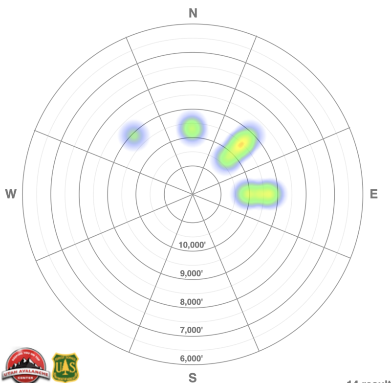
A CONSIDERABLE avalanche danger remains on many slopes at the mid and upper elevations. Human triggered avalanches 1-2' deep remain likely...and may still be triggered from a distance.
Conservative decision making is essential.
As an outlier - wet sluffs and Roof-alanches may be possible today.
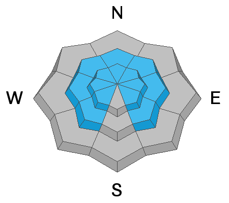
Low
Moderate
Considerable
High
Extreme
Learn how to read the forecast here
Special Announcements
Thanks to the generous support of our local resorts, Ski Utah, and Backcountry, discount lift tickets are now available.
Support the UAC while you ski at the resorts this season. Tickets are available here.
Weather and Snow
Happy Solstice.
But it's been a rough few days around the West:
  • Lone skier fatality near Crested Butte on Friday.
  • Snowmobiler fatality in Wyoming's Salt River Range on Friday.
  • Double skier fatality near Silverton, Colorado on Saturday.
You can read more about these on Avalanche.org/avalanche-accidents

Skies are overcast with a snowflake falling here and there across the range.
We're on the back end of yesterday's warm front that left its mark in no uncertain terms: 40-50mph west to northwest winds high along the ridgelines, warm and humid conditions, and a nice rime crust to top it all off. "Drizzle" was reported at the lower elevations.
Currently, mountain temperatures are in the upper 20s to low 30s. Winds remain from the west-northwest, blowing 15-20mph with gusts to 35. (11k speeds are 30 gusting 40).
We'll get a bit of a break today and tonight ahead of tomorrow afternoon's strong cold front. Temps will drop to the low single digits Tues night and we may see 3-5" of low density snow if we're lucky.
High pressure and clearing skies wrap up the rest of the week.
Recent Avalanches
Only one reported avalanche noted from the backcountry yesterday - a skier triggered pocket 16" deep and 20' wide in Hideaway Park of upper Days Fork of BCC. Elevation 10,100' on a steep northeast facing slope.
Long time professional Bill Nalli gives his impression of the situation HERE.
Below is a rough "heat map" of the reported avalanches since the early Friday avalanche cycle. Dozens have been human triggered; many more ran naturally during the storm itself.
Most of these natural and human triggered slides (commonly triggered at a distance) were 12-18" deep and 50" wide. Some propagated 300' wide - like those in Mineral Fork of Big Cottonwood Canyon.
As you can see, most of these avalanches fall in the mid and upper elevations on northwest through east facing terrain.

You can find all of these reports in the Observations and Avalanches tab in the Menu above or by clicking HERE.
Uncertain of locations? You can select "Map view" on the Observations/Avalanches page or look things up on the Wasatch Backcountry Skiing guide. Or map. Or better yet, download the app,
Ad
Avalanche Problem #1
Persistent Weak Layer
Type
Location
Likelihood
Size
Description
While we heard of only one new avalanche yesterday, collapsing and long shooting cracks along with damning snowpack tests are evidence enough of a generally unstable snowpack. These avalanches are what we call 'Unmanageable' - that is, they are predictable in their unpredictability: they may be triggered at a distance or from below. Note that many of these avalanches have ripped out mid slope and well off the ridgelines.
Continue to give yourself plenty of margin. Travel advice would be to stick to low angle terrain until the snowpack has adjusted.
The snowpack has a hard time adjusting with every event that adds additional stress - like the previous days' strong northwest winds.

These avalanches are failing on the NFL - the November Facet Layer - and unfortunately leave plenty of faceted grains on the bed surface, waiting for the next slab of snow. These are called Repeater avalanches. Repeater slopes can be particularly tricky as they can be difficult to identify with the next blanket of snowfall.
Avalanche Problem #2
Wind Drifted Snow
Type
Location
Likelihood
Size
Description
Soft and hard wind drifts can be triggered primarily along the higher elevations. These drifts may look smooth and rounded or scalloped and wavy. They may also break out above you. Look for them on predominantly north through east to south facing slopes and know that any triggered wind drift may step down into older weak faceted snow.
Avalanche Problem #3
Wet Snow
Type
Location
Likelihood
Size
Description
With a rain/rime event yesterday, warming temperatures, and clearing skies, loose wet sluffs may be triggered at the lower elevations and may pile up deeply in steep walled gullies.
Roof-alanches may be possible as homes may shed the recent storm snow.
General Announcements
Please visit this website with information about Responsible Winter Recreation by the Utah Office of Outdoor Recreation.

This information does not apply to developed ski areas or highways where avalanche control is normally done. This forecast is from the U.S.D.A. Forest Service, which is solely responsible for its content. This forecast describes general avalanche conditions and local variations always occur.