Forecast for the Salt Lake Area Mountains

Trent Meisenheimer
Issued by Trent Meisenheimer on
Sunday morning, December 1, 2019
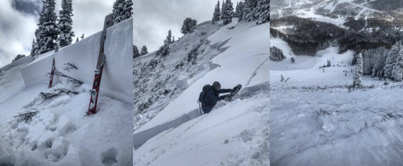
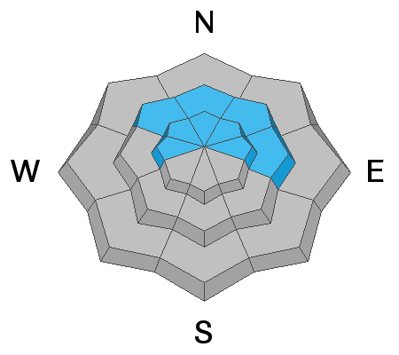
Today, the avalanche danger is HIGH on mid and upper elevation aspects facing northwest to northeast. The danger is CONSIDERABLE on mid and upper elevation slopes that face west and east. Dangerous and deadly slabs of snow hang in balance awaiting a trigger. The strategy in simple AVOID AVALANCHE TERRAIN ALTOGETHER.
There is no secret, if you head to steep northerly facing terrain you will find a deep and deadly avalanche. Avalanches can be triggered from a distance. Avoid being on, underneath, or adjacent to any steep slope.
Slopes facing southwest through southeast that do not harbor old weak faceted snow have a MODERATE danger for wind drifted snow issues.
Low
Moderate
Considerable
High
Extreme
Learn how to read the forecast here
Avalanche Warning
IN EFFECT FROM 6 AM MST THIS MORNING TO 6 AM MST MONDAY
FOR THE CENTRAL AND SOUTHERN WASATCH RANGE, INCLUDING THE WESTERN UINTAS.
THE AVALANCHE DANGER TODAY IS HIGH.
VERY DANGEROUS AVALANCHE CONDITIONS EXIST. HUMAN TRIGGERED AND NATURAL AVALANCHES ARE LIKELY. STAY OFF OF AND OUT FROM UNDER SLOPES STEEPER THAN 30 DEGREES. AVALANCHES MAY BE TRIGGERED FROM A DISTANCE OR FROM BENEATH STEEP SLOPES.
Special Announcements
The First Annual Statewide Avalanche Awareness Week is December 2-7. We have a week full of fun and educational events planned. Check out the schedule here.
Drew Hardesty released the first UAC podcast of the season " Early Season Essentials with Program Director Bo Torrey" check it out HERE.
Weather and Snow
The last snowflakes fell yesterday morning ending an epic weather cycle for the state of Utah. Under partly cloudy skies this morning we should see periods of filtered sun as thin clouds stream overhead from the west throughout the day. Temperatures are in the teens °F at the upper elevations while the lower elevation trail-heads sit in the single digits °F. The northerly winds have calmed down this morning as the flow slowly switches to the west-south-west. Upper elevation anemometers are currently spinning from the west at 5-10 mph gusting 15-20 mph. Below the ridgelines the wind is calm.
Later this afternoon temperatures will climb into the mid 20's °F at 9,000' in elevation. Clouds will fill in, winds increase from the west and we could squeeze a few snowflakes from the atmosphere overnight. Later in the week (Wednesday) it looks like we could see some snow in the 3-6" range. Stay tuned.

Total snow since Monday the 25th is as follows:
  • Wasatch Mountains: 50-70" snow (3.5 - 4.34" h20)
  • Park City Ridgline: 30-40" snow (2.5 - 3.0" h20)
  • Ogden Mountains: 40-50" snow (4.0 - 4.8" h20)
  • Provo Mountains: 24-33" snow (1.6 - 2.1" h20)
Our week in review (including a summary of the early season) can be found HERE.
Recent Avalanches
Observer Mark White was walking on a low angle ridgeline adjacent to a steep bowl on the Park City Ridgline when the slope collapsed and remotely triggered a rather large avalanche in No Name Bowl (Picture Below). This is bullseye information that we can still trigger large and deadly avalanches in the backcountry, especially on slopes that harbor old weak snow at the ground. Other observers were able to get a look around and took note of the extensive avalanche cycle from the past few days. I've highlighted a few of the avalanches below:
  • No Name Bowl: 3.5' deep x 500' wide, running 800' vertical
  • West Monitor Bowl: 2-4' deep x 400' wide, running 800' vertical
  • Scotts Bluff: 2' deep x 200' wide
  • Georges Bowl: 2' deep and unknown how wide
  • Murdock Peak: 2' deep x 500' wide, running 500' vertical
Paradis & Brackelsberg have an excellent observation from Murdock Peak HERE. More information on all the avalanche activity and location can be found on our observations page HERE.
Picture: Mark White - No Name Bowl on the Park City Ridgeline.
Ad
Avalanche Problem #1
Persistent Weak Layer
Type
Location
Likelihood
Size
Description
Dangerous and deadly slabs of snow hang in balance awaiting a trigger on aspects facing west through east at the mid and upper elevations. These avalanches are failing on a weak layer of faceted snow found at the base of the snowpack. Avalanches are 2-4' deep and hundreds of feet wide and likely unsurvivable. Avalanches can be triggered from a distance. Avoid being on, underneath, or adjacent to any steep slope.
The strategy is simple, AVOID AVALANCHE TERRAIN ALTOGETHER. There is no secret, if you head to steep northerly facing terrain you will find a deep and deadly avalanche.
Video: Field day in Upper Days Fork, LCC that highlights why these avalanches are failing.
Avalanche Problem #2
Wind Drifted Snow
Type
Location
Likelihood
Size
Description
The new snow and wind has been relentless over the past week blowing from every direction across many different aspects and elevations. For today, look for and avoid hard and soft slabs of wind drifted snow. These drifts of wind blown snow can be found across many terrain features, cross loaded into gullies and found on mid-slope rollovers. Look for signs of sensitive wind drifted snow, such as shooting cracks, pillowy rounded snow, hollow sounding snow, and avoid those areas.
General Announcements
This information does not apply to developed ski areas or highways where avalanche control is normally done. This forecast is from the U.S.D.A. Forest Service, which is solely responsible for its content. This forecast describes general avalanche conditions and local variations always occur.