Forecast for the Salt Lake Area Mountains

Drew Hardesty
Issued by Drew Hardesty on
Tuesday morning, November 26, 2019
While most terrain has a MODERATE danger, pockets of CONSIDERABLE danger exist in upper elevation wind drifted slopes. Human triggered avalanches are possible and may be triggered from a distance. Sluffing may also be expected in steep terrain today.
Outlook: the outlook is not good for the rest of the week as the danger may reach HIGH in the coming days. This includes sidecountry terrain. Please spread the word to friends and neighbors who may be unaware.
Low
Moderate
Considerable
High
Extreme
Learn how to read the forecast here
Avalanche Watch
IN EFFECT FROM 6 AM MST THIS MORNING TO 6 AM MST WEDNESDAY MORNING
FOR THE CENTRAL AND SOUTHERN WASATCH RANGE, INCLUDING THE WESTERN UINTAS.
THE AVALANCHE DANGER IS EXPECTED TO RISE TO HIGH WITH THE FORECAST HEAVY SNOW AND WIND.
DANGEROUS AVALANCHE CONDITIONS ARE EXPECTED. HUMAN TRIGGERED AND NATURAL AVALANCHES ARE LIKELY. STAY OFF OF AND OUT FROM UNDER SLOPES STEEPER THAN 30 DEGREES. AVALANCHES MAY BE TRIGGERED FROM A DISTANCE OR FROM BENEATH STEEP SLOPES.
Special Announcements
Alta Ski Area is now closed as they prepare for opening on the 29th. Access to Grizzly Gulch and the Catherine's area via the Summer Road will remain open. The open and closed resorts have different uphill travel policies. Check with each resort for the current information.
Terrain in unopened resorts must be treated as backcountry.
The First Annual Statewide Avalanche Awareness Week is December 2-7. We have a week full of fun and educational events planned. Check out the schedule here.
Click on the Education menu on our webpage for a full list of classes from the UAC and other providers. Check out the Know Before You Go eLearning program for free, online, avalanche classes.
Weather and Snow
A good old fashioned cold front crashed through the range yesterday, dropping temperatures into the single digits and delivering 7-10" of 4-5% density snow to the mountains. (Snow-water-equivalents are 0.32-0.47"). Ridgeline anemometers are blowing 25-30mph with gusts to 40 while 11,000' wind speeds are humming at 30-35mph with gusts to 60. The good news is that they'll lose steam as they slowly back to the southwest and south during the day. Current wind chill, however, is -20°F. Bundle up.
We'll see a bit of a break today with partly-becoming-mostly cloudy skies, light southwest winds, and temperatures that may not reach the double digits. Enjoy the breather while you can. A storm spinning off the Oregon coast will be the main event over the next several days, ushering in heavy and heavier snowfall, strong southerly winds, and dangerous avalanche conditions. Up to and over two feet of snow can't be ruled out by early weekend. (Plus there are hints of another system for early next week.) Buckle up.
Recent Avalanches
Bellwether - noun - an indicator or predictor of something.
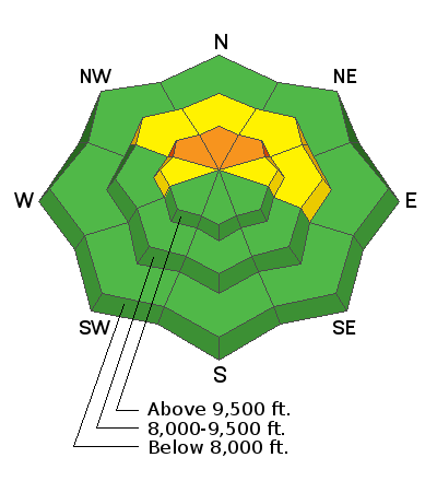
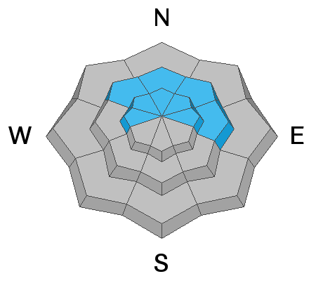
A backcountry skier triggered a shallow soft slab into the older weak snow 6" deep and 20' wide in upper Hidden Canyon in the Brighton backcountry yesterday. Elevation and aspect were 9900' and northeast facing. I expect more of these - though larger - today.
Ad
Avalanche Problem #1
Persistent Weak Layer
Type
Location
Likelihood
Size
Description
I suspect that there was just enough new snow and wind to create unstable avalanche conditions in some very localized terrain of the upper elevation northwesterly to easterly slopes. If you're just getting up to speed, the pre-existing base is really a horror-show of exceedingly loose and weak faceted snow with some crusts and surface hoar thrown in for good measure. It's not good and I don't trust it.
Human triggered slides will be possible in this localized terrain and may be triggered remotely. Audible collapsing and shooting cracks are clear evidence of instability.
Avalanche Problem #2
New Snow
Type
Location
Likelihood
Size
Description
Sluffing may be expected in the cold smoke on the steepest west to north to east facing slopes. The surface snow is so weak that the new snow will bond poorly and scrape down to the underlying November 20th crust. These point-release avalanches are likely to run with human provocation, leaving decent debris piles.
Additional Information
Looking down the road, expected heavy dense snowfall with strong southerly winds will not only be too much for yesterday's low density snow as a failure plane, but the old weak facets and crusts from the early storms. I expect probably more than one natural avalanche cycle this Thanksgiving week. The solution will be to choose terrain that did not harbor old snow (southeast to south to some westerly aspects) or to choose low angle terrain with nothing steeper above.
General Announcements
This information does not apply to developed ski areas or highways where avalanche control is normally done. This forecast is from the U.S.D.A. Forest Service, which is solely responsible for its content. This forecast describes general avalanche conditions and local variations always occur.