Forecast for the Skyline Area Mountains

Brett Kobernik
Issued by Brett Kobernik on
Monday morning, April 3, 2023
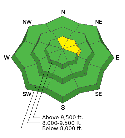
There is a pockety MODERATE avalanche danger rating in the upper elevations where a person could trigger a wind drift or wind slab.
Strong southwest wind has been transporting snow and creating scattered drifts and slabs. If you trigger something, it most likely won't be all that large but still could be dangerous.
If you avoid upper elevation steep slopes where these drifts and slabs are present, the avalanche danger is generally LOW.
Low
Moderate
Considerable
High
Extreme
Learn how to read the forecast here
Weather and Snow
Current Conditions: Windy! We've had pretty strong ridgetop southwest wind for the last 24 hours. Speeds are gradually slowing. Temperatures got into the mid 30s on Sunday and hovered around freezing overnight. Riding conditions are hit or miss with a mix of heat crusts, wind damaged snow and soft carvable settled snow

Mountain Weather: We have a storm moving in today and should see some snowfall this afternoon. Temperatures shouldn't warm too much and will start to cool this afternoon. Wind will gradually shift and blow from the west and northwest and increase in speed again. The majority of the snowfall will happen tonight with lingering periods of snow through Wednesday. 12 to 18 inches seems reasonable by the time the storm is done.
Ad
Avalanche Problem #1
Wind Drifted Snow
Type
Location
Likelihood
Size
Description
Pockety wind drifts and wind slabs scattered around the higher terrain is the only thing of concern today. These pockets probably won't be all that sensitive and won't produce large avalanches. Just be aware that they could crack out on you if you decide to get into steeper upper elevation terrain.
General Announcements
This forecast is from the U.S.D.A. Forest Service, which is solely responsible for its content. This forecast describes general avalanche conditions and local variations always occur.