Forecast for the Skyline Area Mountains

Brett Kobernik
Issued by Brett Kobernik on
Saturday morning, April 1, 2023
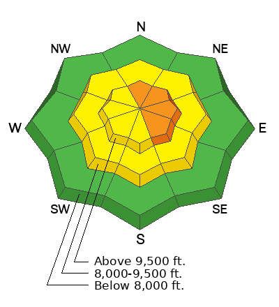
There is a CONSIDERABLE avalanche danger rating for upper elevation northwest through southeast facing terrain.
Human triggered avalanches are likely on steep upper elevation slopes where the wind has drifted and deposited snow.
If you avoid areas where the wind has drifted snow, the avalanche danger is much lower.
Watch for wet avalanche activity during the heat of the day.
Low
Moderate
Considerable
High
Extreme
Learn how to read the forecast here
Weather and Snow
Current Conditions: The wind has slowed down somewhat overnight but is still in the moderate speed range from the southwest along the higher more exposed terrain. Temperatures have been hovering around 20˚F for the last 24 hours. Riding conditions are excellent out of the wind affected terrain.

Mountain Weather: We'll see mostly sunny skies today with temperatures into the mid to upper 30s. Wind from the southwest will be moderate in speed along the higher terrain and will increase late in the afternoon. We'll have similar temperatures on Sunday with more clouds and stronger southwest wind. A storm moves in for the first part of the week which could potentially bring 12 to 18" of new snow by mid week.
Recent Avalanches
Because of poor visibility on Friday, I was not able to see around in the higher terrain very well. I did note a few medium sized avalanches due to cornice falls that happened during the storm. They were on northeast facing slopes right below the ridgelines.
Ad
Avalanche Problem #1
Wind Drifted Snow
Type
Location
Likelihood
Size
Description
The main avalanche problem today is wind drifted snow.
Here's what I know:
  • We received a foot of fresh snow and the wind was actively drifting it in the higher terrain, building cornices and forming wind slabs.
  • Plumes of snow were clearly visibly coming off the ridges on Friday.
  • There was at least some natural avalanche activity during the storm.
  • Fresh drifts and slabs are always the most sensitive when they are forming and directly afterward.
Here's what I don't know:
  • Have the fresh drifts and slabs stabilized?
  • Will they release today if provoked?
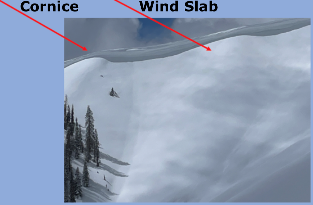
Since these drifts and slabs just formed yesterday, they will most likely still be sensitive today. The rule of thumb is to wait two days after new snow and wind before monkeying around in steeper terrain. The most likely place to trigger an avalanche today will be just below the ridges in the higher very steep slopes that face north through southeast. Cornices are huge and you should avoid being on or underneath them. Below is an image of the type of terrain you'll want to avoid today.
General Announcements
This forecast is from the U.S.D.A. Forest Service, which is solely responsible for its content. This forecast describes general avalanche conditions and local variations always occur.