Check out our Holiday Auction

Forecast for the Skyline Area Mountains

Brett Kobernik
Issued by Brett Kobernik on
Tuesday morning, March 5, 2024
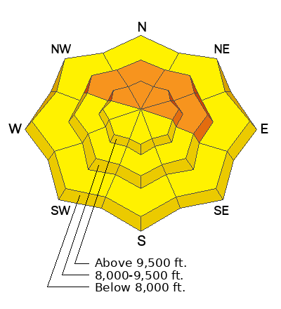
The avalanche danger rating for the Skyline is CONSIDERABLE.
Wind slabs and fresh drifts that formed during the storm are still dangerous.
Human triggered avalanches are likely on any steep slope that has recent deposits of wind drifted snow.
The most likely places to trigger an avalanche are on steep slopes that face northwest through east in the mid and upper elevation terrain.
Low
Moderate
Considerable
High
Extreme
Learn how to read the forecast here
Weather and Snow
Current Conditions: A few more inches of snow accumulated in the last 24 hours. Storm totals since Friday are pushing 30 inches. I measured 2.5" of water in 27" of snow. The first half of the storm was higher density snow and last half was cold powder. It was still breezy on Monday from the west southwest. Temperatures stayed in the upper teens in the higher terrain which kept the snow cold and powdery. Lower elevations warmed up and became damp. There was some broken sky above Horseshoe Mountain this morning but it was also snowing lightly up Fairview Canyon.
Mountain Weather: It looks like we'll see mostly cloudy skies today with the chance for periodic snowfall. Accumulations won't be too much. Clouds might break a bit here and there, more so this afternoon. We'll have light to moderate speed wind from the southwest. The speed may increase a bit later in the afternoon. Temperatures will get into the mid to upper 20s. This pattern looks similar for Wednesday and Thursday then some clearing on Friday and Saturday.
Recent Avalanches
We don't know the extent of any natural avalanche activity in the higher terrain that happened during the storm due to poor visibility and difficult travel conditions. In the mid and lower elevations the snow was well behaved and I only noticed minor sluffing that occurred during the storm.
Ad
Avalanche Problem #1
Wind Drifted Snow
Type
Location
Likelihood
Size
Description
Drifts, slabs and cornices that formed from wind drifting snow during the storm are still likely to crack out and avalanche if provoked. You're going to want to avoid steep slopes anywhere the wind has drifted and deposited snow. These drifts and slabs are stabilizing but you'll want to give them a day or two before trusting your life to them.
The most likely places to trigger an avalanche today are on mid and upper elevation very steep slopes that faces northwest through east. On all aspects including mid elevations, watch for and avoid wind loaded steep slopes and terrain features.
General Announcements
This forecast is from the U.S.D.A. Forest Service, which is solely responsible for its content. This forecast describes general avalanche conditions and local variations always occur.