Check out our Holiday Auction

Forecast for the Skyline Area Mountains

Brett Kobernik
Issued by Brett Kobernik on
Tuesday morning, February 6, 2024
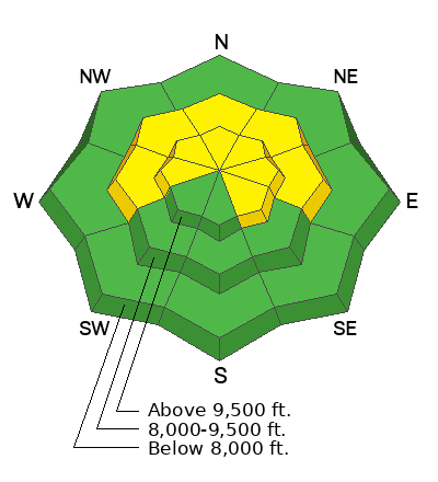
The overall avalanche danger is MODERATE on the Manti Skyline.
Recently formed snow drifts and slabs of snow can be triggered today in upper elevation wind exposed terrain.
Generally, these won't pose all that much threat but could push you around and cause injury.
There is still a slight chance a person could trigger a deeper and more dangerous avalanche that breaks into weak sugary snow near the ground.
Low
Moderate
Considerable
High
Extreme
Learn how to read the forecast here
Weather and Snow
Current Conditions: A trace to an inch of snow fell on Monday. There was just enough breeze to drift some snow around a bit. Temperatures have been hovering in the mid 20s with a gradual warming trend.
Mountain Weather: We have a series of messy looking storms moving through for the rest of the week. Basically, these systems are digging too far south of our region and we're going to get table scraps for snow.
The first system that starts to produce snow late today, once again, has a very direct south or southeast flow which won't produce all that much snow accumulation. I'm only anticipating a few inches of snow by tomorrow morning. Temperatures will be around 30˚F and wind from the south looks like it'll be a bit breezy. The flow shifts around more from the west on Wednesday and we should see periods of snow on and off through Wednesday night which should deliver a few more inches of accumulation. This messy pattern looks like it will continue through Saturday with a few periods of snow accumulation each day. We'll be in a gradual cooling trend through the week.
Recent Avalanches
There have been no reported avalanches recently. There was a report of a slope cracking out but not sliding while riders were nearby. It was adjacent to the "Super Monster" in Ephraim Canyon, which is a north northeast facing slope at about 10,000' in elevation. Thank you Brian Meade for passing on that info.
Ad
Avalanche Problem #1
Wind Drifted Snow
Type
Location
Likelihood
Size
Description
People can trigger shallow avalanches today involving the upper layers of newer snow which has been drifted into slabs. These don't pose a huge threat but you'll want to avoid triggering them nonetheless. Look for large "pillowy" looking deposits and avoid them on steep terrain. If the snow feels "thick", this is another clue that you're in wind affected snow. Cracking within the snow surface is another clue. The most likely places to trigger something is in the higher steep terrain just below ridges and cornices especially on the east half of the compass.
Avalanche Problem #2
Persistent Weak Layer
Type
Location
Likelihood
Size
Description
Keep in mind that there is still a chance that a person could trigger a deeper avalanche that breaks into weak snow near the ground. The weak snow is still down there and hasn't gained enough strength yet for me to call it completely stable in all areas. Locations where the snowpack is shallower and/or in rocky terrain is where the likelihood of triggering a slide is greater. The chances for triggering one of these deeper avalanches is becoming less likely but it's still a gamble to try and figure out which slopes will stay in place and which ones will come crashing down on you.
General Announcements
This forecast is from the U.S.D.A. Forest Service, which is solely responsible for its content. This forecast describes general avalanche conditions and local variations always occur.