Forecast for the Skyline Area Mountains

Brett Kobernik
Issued by Brett Kobernik on
Saturday morning, December 24, 2022
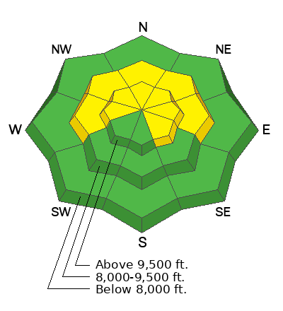
The avalanche danger is rated at MODERATE today.
Human triggered avalanches are possible but not likely.
Upper elevation steep slopes that face north through southeast which have a recent deposit of wind drifted snow are the most likely place to trigger an avalanche.
Low
Moderate
Considerable
High
Extreme
Learn how to read the forecast here
Weather and Snow
Current Conditions: The wind has been from the northwest and has been fairly light. Temperatures are pretty mild with most stations reading in the mid 20s over the last 24 hours. The snow surface conditions are a mixed bag after the strong wind a few days ago.
Mountain Weather: We'll see cloudy skies for today with the chance for some clearing later on. Temperatures will get into the upper 20s and wind from the northwest will be light this morning and increase in speed a bit as the day goes on. Sunday looks a little more clear with continued warm daytime temperatures. A decent looking series of storms is still shaping up starting Tuesday.
Ad
Avalanche Problem #1
Persistent Weak Layer
Type
Location
Likelihood
Size
Description
Your biggest avalanche threat is triggering an avalanche that breaks into the November Persistent Weak Layer (DETAILS HERE). The chances for triggering a slide are becoming less but consequences remain high. Riders reported collapsing (whumpfing) of the snowpack on Friday. Red flag. This is a clear indicator that there are places a person could trigger an avalanche. The most likely place would be upper elevation steep slopes where the wind has deposited a fresh drift or slab of snow. The safest bet is to continue to stay off slopes steeper than 30˚ until the Persistent Weak Layer is stable.
For some insight on a Moderate avalanche danger rating with a Persistent Weak Layer, read THIS BLOG POST BY FORECASTER ERIC TRENBEATH.
General Announcements
This forecast is from the U.S.D.A. Forest Service, which is solely responsible for its content. This forecast describes general avalanche conditions and local variations always occur.