Forecast for the Skyline Area Mountains

Brett Kobernik
Issued by Brett Kobernik on
Sunday morning, December 11, 2022
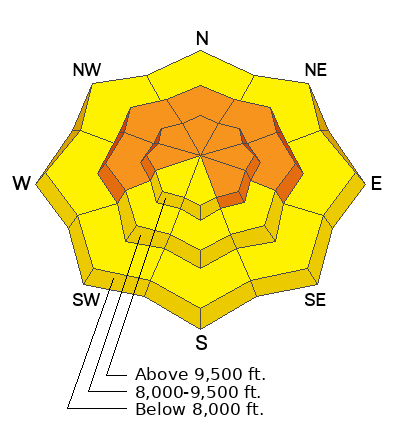
The avalanche danger rating is CONSIDERABLE today. Human triggered avalanches are likely on steep slopes.
To stay safe, avoid being on or below slopes steeper than 30˚.
Low
Moderate
Considerable
High
Extreme
Learn how to read the forecast here
Weather and Snow
Current Conditions: Riding conditions on Saturday remained quite good. Overall snow cover is excellent for this time of the season. The snowpack is fairly supportable although it's easy to find spots where you will punch into the loose sugary layer from November. It looks like southeast wind picked up overnight and is stirring things up even down into the canyons a bit. Temperatures got up to around 30˚F at 9000' yesterday and are in the mid 20s now.
Mountain Weather: We'll see increasing clouds and breezy southerly wind today. High temperatures will be in the mid 20s. There's a chance for snow this afternoon as the anticipated storm moves in but most of it will fall tonight into Monday during a southerly flow. We should see lingering periods of snow into Tuesday as the flow shifts northwest. I still don't think this is going to be a huge snow producer for the Skyline. I'm expecting totals of 4 to 8 inches by Tuesday but hedging my bets on potentially a little more.
Ad
Avalanche Problem #1
Persistent Weak Layer
Type
Location
Likelihood
Size
Description
I found more evidence on Saturday that tells me that our buried Persistent Weak Layer of loose sugary faceted snow from November is still active. The biggest clue is the crack pictured below. This was triggered by a snowmobiler probably on Friday but possibly early Saturday. It broke down into the loose sugary facets from November. This clearly demonstrates that avalanches are still likely to break into this layer. This layer will continue to produce avalanches over the next couple of weeks.
General Announcements
This forecast is from the U.S.D.A. Forest Service, which is solely responsible for its content. This forecast describes general avalanche conditions and local variations always occur.