Forecast for the Skyline Area Mountains

Brett Kobernik
Issued by Brett Kobernik on
Saturday morning, January 28, 2023
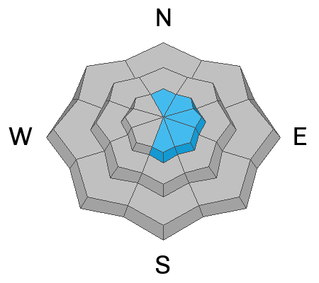
There is a MODERATE avalanche danger rating for upper elevation terrain where recent deposits of wind drifted snow are present.
These are most pronounced on the east half of the compass but watch for crossloaded slopes on all aspects.
If you avoid the steep and windy higher terrain, the avalanche danger is generally LOW.
Low
Moderate
Considerable
High
Extreme
Learn how to read the forecast here
Weather and Snow
Current Conditions: The wind drifted snow on Friday but not as much as I anticipated. It was from the west and speeds stayed in the moderate category for the most part with a few stronger gusts mid day. It has slowed a bit now but is still light to moderate in speed. Temperatures made it into the mid 20s on Friday and are around 20˚F this morning. A minor weather disturbance moved through and added a trace to an inch of snow overnight.
Mountain Weather: We'll see light snowfall this morning with another trace to a few inches possible. Temperatures won't get much warmer and will actually decrease this afternoon. Wind from the west will be light to moderate in speed and decreasing as the day goes on. A storm will swoop through from the north on Sunday bringing periods of snow mainly afternoon into the evening. Snow totals don't look all that impressive. I'm anticipating 2 to 5 inches total by Monday.
Ad
Avalanche Problem #1
Wind Drifted Snow
Type
Location
Likelihood
Size
Description
Recently formed wind drifts and slabs are your only concern out there today. These formed on Friday for the most part so they'll be less sensitive today. That said, I'd continue to avoid steep upper elevation slopes that have any sign of wind drifted snow on them. "Pillowy" looking drifts and places where the snow feels "thick" are what you want to look for and avoid. This is not a huge threat but something you should be aware of.
General Announcements
This forecast is from the U.S.D.A. Forest Service, which is solely responsible for its content. This forecast describes general avalanche conditions and local variations always occur.