Check out our Holiday Auction

Forecast for the Skyline Area Mountains

Brett Kobernik
Issued by Brett Kobernik on
Saturday morning, January 27, 2024
The avalanche danger is rated CONSIDERABLE on steep slopes in the mid and upper elevations that face west, north and east.
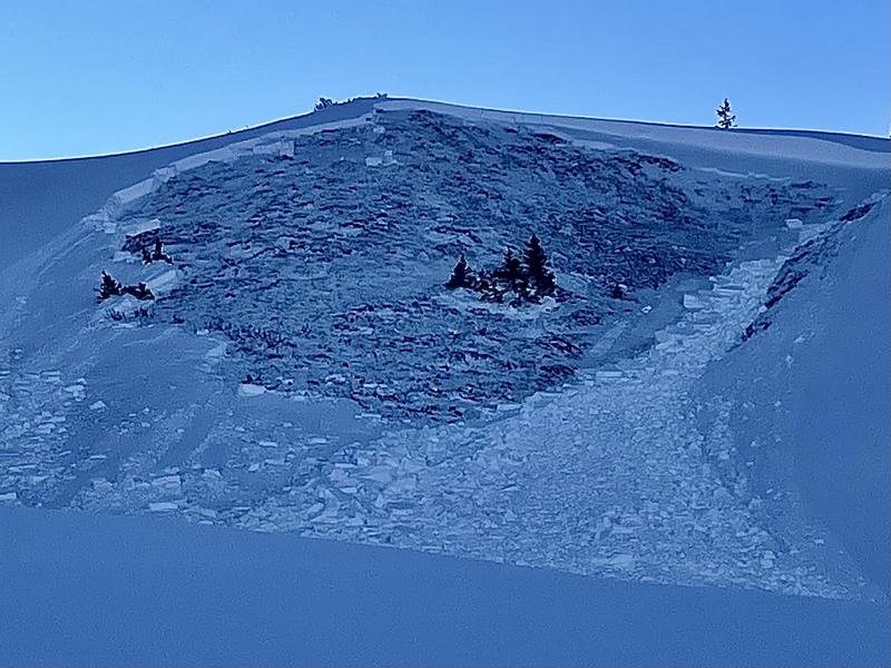
Recent snowmobile triggered avalanches are proof that the snowpack remains unstable.
There is less danger in lower elevations as well as on southerly facing slopes.
Low
Moderate
Considerable
High
Extreme
Learn how to read the forecast here
Special Announcements
MOTORIZED BACKCOUNTRY 101 AVALANCHE CLASS
One evening of online presentations, one full day out in the backcountry with instructors.
You'll learn all the basics of rescue and how to read the snow and make good decisions in avalanche terrain.
Hosted by the Utah Avalanche Center
Feb 2nd and 3rd - MORE DETAILS HERE
Weather and Snow
Current Conditions: Temperatures dropped into the single digits in the canyon bottoms overnight. Upper elevations are in the teens to around 20˚F. Wind is light to moderate in speed from the northwest. Skies are partly cloudy. Riding conditions are not bad. The small amounts of new snow that trickled in through the week have kept the surface nice and soft.
Mountain Weather: We have a stretch of clear weather coming. Today we'll see sun and high temperatures up around 30˚F and moderate speed ridgetop wind from the northwest. Temperatures warm for the next few days. Clear weather lasts through mid week next week with the possibility of a series of snow storms starting Friday.
Recent Avalanches
I was down on the Fish Lake in the Gooseberry region on Friday and my partner and I remotely triggered five avalanches that released simultaneously. What should be noted is that these avalanche paths have already slid once earlier this season. They have been reloaded and, obviously, there was still loose sugary faceted snow in the bed surfaces which caused them to avalanche again. MORE DETAILS HERE
Ad
Avalanche Problem #1
Persistent Weak Layer
Type
Location
Likelihood
Size
Description
The Gooseberry region I visited on Friday has an extremely poor snowpack structure. It is similar to what I've seen around the Ephraim/Manti Canyon area. Other areas on the Skyline have a slightly better structure but one thing remains the same everywhere: the base layers consists of loose sugary faceted snow. You cannot trust that stuff.
You are going to start seeing tracks on steeper terrain where people are lucky to get away with it. Don't be fooled. The snowpack remains in an unstable condition.
For a recap of how the season has progressed up to this point, check out the SEASONAL SNOWPACK SUMMARY.
General Announcements
This forecast is from the U.S.D.A. Forest Service, which is solely responsible for its content. This forecast describes general avalanche conditions and local variations always occur.