Join us at our 2nd Annual Blizzard Ball

Forecast for the Skyline Area Mountains

Brett Kobernik
Issued by Brett Kobernik on
Thursday morning, January 23, 2025
.
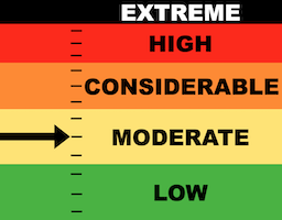
The avalanche danger on the Manti Skyline is MODERATE.
Fresh drifts and wind slabs have formed from all the recent wind. This is your main concern today as you may still trigger these today.
Some of these drifts have formed in areas that hold old weak sugary snow from Nov & Dec. This is the most dangerous situation as these can break deep into the snowpack.
Low
Moderate
Considerable
High
Extreme
Learn how to read the forecast here
Special Announcements
URGENT!! Battery replacement required for anyone who received batteries from one of our participating "Batteries for Beacons" shops. We've found that the Duracell Procell AAA batteries are too short in length and may not make contact in avalanche beacons causing them to malfunction. DETAILS HERE
Weather and Snow
Current Conditions: Moderate to strong northwest wind continued Wednesday and finally has slowed. It's still a little breezy along the highest peaks but it's much calmer down off exposed terrain. Temperatures were frigid again overnight with lows in the single digits to around zero. Numerous days of wind has been hard on the riding conditions.
Mountain Weather: We'll see mostly clear skies with light northwest wind today. Temperatures should get up around 20˚F. A few clouds move in Friday with warmer temperatures. Overall, the future weather pattern looks like junk for snowfall. A low pressure system will form along the coast of California Saturday and slowly drift south then east through Arizona. This does very little for us as far as any significant snow.
Ad
Avalanche Problem #1
Wind Drifted Snow
Type
Location
Likelihood
Size
Description
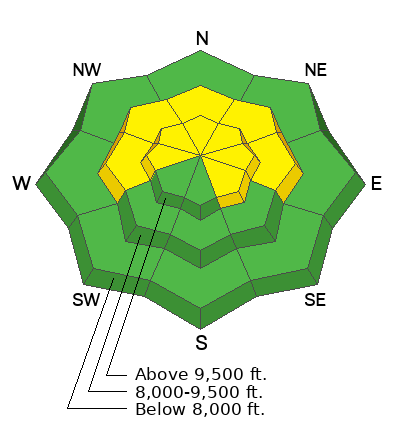
You will again want to be on the lookout for areas that have recent deposits of wind drifted snow. These drifts and slabs may be sensitive to people still today. The most likely places to find them are right below ridgelines on northeast, east and southeast facing steep slopes. Simply avoid any steep slope that looks like the wind has been depositing snow onto it. .
Avalanche Problem #2
Persistent Weak Layer
Type
Location
Likelihood
Size
Description
Loose sugary faceted snow at the base of the snowpack remains a concern especially in areas where the overall depth is less than about 3 feet. These areas have the weakest snow. The weak snow is most pronounced above 8000 feet in elevation on west, north, and east facing slopes. Recent wind has formed drifts and slabs on top of this weak sugary snow in many places. If you trigger one of these, it could break 2 to 4 feet deep.
Again, avoidance is the key. Simply avoid any steep slope that looks like the wind has been depositing snow onto it.
General Announcements
This forecast is from the U.S.D.A. Forest Service, which is solely responsible for its content. This forecast describes general avalanche conditions and local variations always occur.