Forecast for the Skyline Area Mountains

Brett Kobernik
Issued by Brett Kobernik on
Saturday morning, January 14, 2023
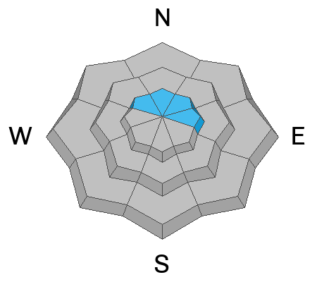
The majority of the terrain has a LOW avalanche danger rating today. Upper elevation NW, N, NE and E facing slopes have a MODERATE danger rating.
Human triggered avalanches are possible but unlikely.
The most likely places to trigger an avalanche today would be in very steep upper elevation slopes that face northwest, north, northeast or east where wind has drifted snow.
Shallow rocky locations in the upper elevations would be another place where a human triggered avalanche is possible.
Low
Moderate
Considerable
High
Extreme
Learn how to read the forecast here
Weather and Snow
Current Conditions: Unseasonably warm temperatures have been with us for the last 24 hours. On Friday the snow surface became damp on the sunny slopes and all aspects up to near 9000'. Temperatures at 9500' are around 30˚F this morning. Wind from the southwest has been light to moderate in speed over the last 24 hours. It increased just a bit overnight. You'll still find plenty of soft but dense snow on the surface that is providing nice riding conditions.
Mountain Weather: We'll have increasing clouds today with the chance for light snowfall later this afternoon. Temperatures remain mild this morning and then will cool into the low 20s this afternoon. Wind will be from the southwest with moderate speeds. Snowfall will increase tonight and into Sunday. The flow will again be from the southwest. Temperatures will be cooler with this storm compared to the last resulting in lower density snow. I'm anticipating 5 to 10 inches of snow by Sunday afternoon. It looks like more chances for snow Monday and Tuesday. Snow will slowly stack up but no huge amounts. This is the best case scenario for continued stabilization of our snowpack.
Ad
Avalanche Problem #1
Normal Caution
Type
Location
Likelihood
Size
Description
The mild temperatures continue to rapidly settle and stabilize the snowpack.
Any new snow instabilities from the last storm should be stable by now. Exceptions would be large wind drifts on very steep slopes. Also, don't screw around with cornices as they are prone to breaking off.
As far as the November Persistent Weak Layer, the last known avalanche that broke into that layer was on January 2nd in Ephraim Canyon. Since then, there have been no reports of collapsing of the snowpack. Also, we gave the snowpack a pretty good thump during the last storm with the addition of 1 to 2 feet of high density snow along with fairly strong wind. As far as I know, this resulted in no avalanches breaking into the deeply buried weak layer.
Use standard backcountry protocol:
  • Make sure everyone has the proper rescue gear (beacon, shovel, probe).
  • One person at a time on steep slopes.
  • Clear the runout zone at the bottom.
General Announcements
This forecast is from the U.S.D.A. Forest Service, which is solely responsible for its content. This forecast describes general avalanche conditions and local variations always occur.