Forecast for the Salt Lake Area Mountains

Trent Meisenheimer
Issued by Trent Meisenheimer on
Sunday morning, February 23, 2025
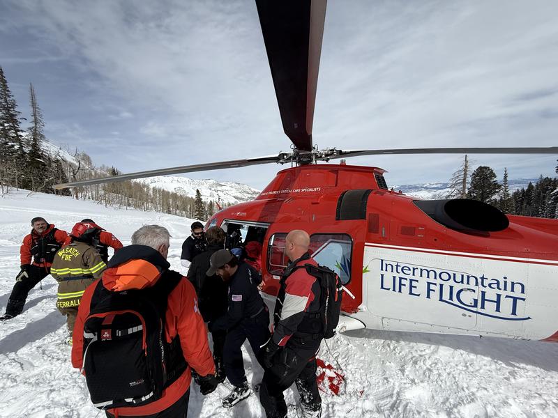
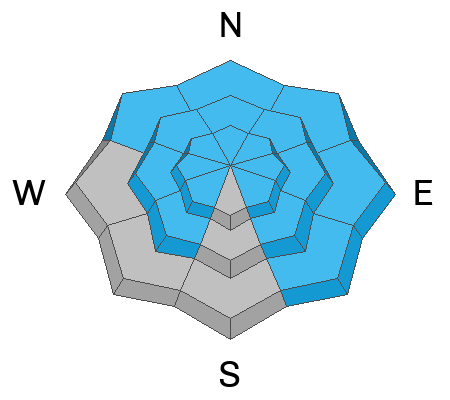
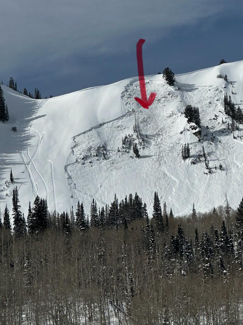
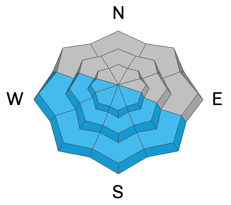
The avalanche danger is CONSIDERABLE on slopes at the mid and upper elevations facing west, northwest, north, northeast, east, and southeast. Here, slab avalanches may break down several feet deep into weaker layers in the snowpack. Human-triggered avalanches are likely.
These are tricky and dangerous conditions that require careful and continual evaluation of the snowpack and terrain.
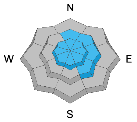
Low
Moderate
Considerable
High
Extreme
Learn how to read the forecast here
Special Avalanche Bulletin
The Utah Avalanche Center is issuing a Special Avalanche Bulletin after a series of storms in the last week has left a thick blanket of snow at all elevations, creating excellent powder riding conditions while also elevating the backcountry avalanche danger. Don't let the fresh snow and sunshine influence your decision-making - avalanche conditions remain dangerous, and careful snowpack and terrain analysis are required for backcountry travel. Fortunately, there are great riding and travel conditions away from avalanche terrain on slopes less than 30° in steepness.
Weather and Snow
Under clear skies, mountain temperatures range from 15-25 °F. Overnight, the wind picked up from the west-northwest and is now blowing 10-15 mph with gusts into the 20s across upper-elevation terrain. At 11,000', the wind is blowing west-northwest 30-40 mph with gusts close to 50 mph.
This morning, the flow will back to the west as our ridge flattens out. This will lead to increasing clouds throughout the day and maybe a few inches of new snow. The wind will remain from the west and blow at speeds of 10-20 mph. Temperatures will rise into the low to mid-30s °F.
Recent Avalanches
Unfortunately, Colorado reported an avalanche fatality yesterday, with a rider triggering an avalanche that broke into a persistent weak layer. In Utah, we had four very close calls, and it seems we got fortunate yesterday that no one died. Three of the four close calls were avalanches breaking deeper in the snowpack. In each case, the riders were caught, carried, and injured. Lifeflight was called to Ant Knolls for leg and chest injuries (photo below). In Logan, someone knocked their front teeth out. Mt Aire, luckily, only led to bumps and bruises. On Friday in Provo, someone narrowly escaped a wet slide in a steep couloir that would have ended badly (links below).
Powderbirds used explosives yesterday and triggered three significant avalanches on northerly-facing terrain. Each slab avalanche broke into faceted snow, and some were a few hundred feet wide, running full track.
Mt. Aire
Ant Knolls
Crows Foot (Provo)
Logan
All observations
Ad
Avalanche Problem #1
Persistent Weak Layer
Type
Location
Likelihood
Size
Description
Deadly slabs of snow are just hanging in the balance, waiting for a trigger. Remember, humans make great triggers. Yesterday, we saw many large slab avalanches fail on buried persistent weak layers. These recent avalanches should tell us that avalanches can still be triggered today. These are large avalanches, and the consequences of being caught in them are likely season-ending or worse. My advice would be to avoid slopes steeper than 30 degrees.
Below are the four buried weak layers we are tracking:
  • Old-faceted snow near the base of the snowpack. This layer is more pronounced in shallow snowpack areas (less than 4 feet deep) or steep rocky terrain.
  • Repeater slopes. Meaning slopes that have previously avalanched one or more times this season.
  • Late January facets are found on many aspects.
  • Facet/crust combos on solar slopes, including low- and mid-elevation southeast-facing terrain.
Avalanche Problem #2
Wind Drifted Snow
Type
Location
Likelihood
Size
Description
The wind from the west has already picked up, and there is plenty of snow available for transport. I would be on the lookout for new sensitive soft slabs of wind-blown snow. Remember, if you trigger a wind slab, there is a chance it can step down into a deeper weaker layer, making a much more dangerous avalanche.
Avalanche Problem #3
Wet Snow
Type
Location
Likelihood
Size
Description
The sun is strong this time of year and it doesn't take much to turn cold snow into damp/wet snow. Be on the lookout for signs of wet snow avalanches. If you're seeing roller balls it's time to change to a cooler aspect.
General Announcements
This information does not apply to developed ski areas or highways where avalanche control is normally done. This forecast is from the U.S.D.A. Forest Service, which is solely responsible for its content. This forecast describes general avalanche conditions and local variations always occur.