Forecast for the Salt Lake Area Mountains

Nikki Champion
Issued by Nikki Champion on
Wednesday morning, December 4, 2019
Today the avalanche danger is CONSIDERABLE on most upper elevation slopes on the northern end of the compass including west, east and southeast slopes. The danger is also CONSIDERABLE on mid-elevation slopes facing northwest through northeast east. There is a MODERATE danger on all other mid-elevation slopes and a LOW avalanche danger on all slopes below 8000 feet.
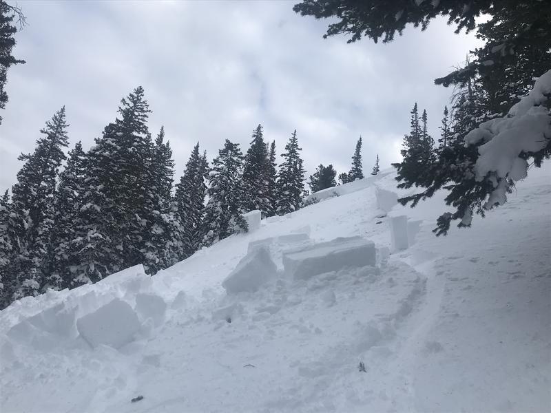
Today, the sensitivity has decreased but dangerous avalanche conditions still exist. Last weekend a large avalanche cycle occurred, there are still chances of triggering a large, deadly avalanche today. Use careful snowpack evaluation, cautious route-finding and conservative decision making.
Low
Moderate
Considerable
High
Extreme
Learn how to read the forecast here
Special Announcements
The first UAC podcast of the season " Early Season Essentials with Program Director Bo Torrey" check it out HERE.

The Supreme area of Alta ski area is now closed to the public as the ski patrol gets this terrain ready for the season.

Get one of these cool t-shirts to support the UAC and other avalanche centers across the U.S.
Weather and Snow
Yesterday was warm, with high temperatures in the 30s to low 40s. The morning temperatures are generally in the mid to upper 20s at trailheads and mid-20s at ridgelines, a shift came around 1 am this morning in which temperatures began climbing quickly.
Winds remained westerly through the most the day blowing 10-15 mph and gusting into the upper teens.
Total snow depths are 2-3 feet.
The combination of warm temperatures and sunshine has led to a wet snow surface and roller balls on the south and west-facing slopes.
Today a quick-moving storm will be coming in from the southwest and gradually spreading to the northeast this evening. This storm could bring us 2-6 inches of snow, and another 0.2 - 0.7 inches of water. With this storm, temperatures will stay in the upper 20s and winds will generally be 15-20 mph, gusting up to 25 mph from the SSW.
Recent Avalanches
In the backcountry, avalanche activity is still being reported. Monday, December 2nd a snowboarder triggered an avalanche on an NE aspect at 9600 in Hidden Canyon. This avalanche was 2 feet deep and 50 feet wide. Yesterday a fresh-looking avalanche was reported in Jaws on an N aspect at 9800 ft. This avalanche was 2.5 feet deep and 80 feet wide and broke in or on the early season facets.
Ski patrols continued to test many slopes with explosives and found a few remaining slopes that could produce an avalanche after triggering many large, scary avalanches on mid and upper elevation slopes last week. A full list of avalanches since Wednesday can be found HERE.
Photo of Hidden Canyon Avalanche - See full report HERE.
Photo of Jaws Avalanche - Full Report HERE
Ad
Avalanche Problem #1
Persistent Weak Layer
Type
Location
Likelihood
Size
Description
The problem still exists. While warm temperatures are helping the snowpack, it is not an overnight healing process. Continued avalanche activity demonstrates that dangerous avalanche conditions still exist on any slope that had any snow before last week. Last week’s storm system left a 2-3 foot soft slab sitting on top of a foot of weak facets at the ground. These lingering facets can be found above 9500 feet facing W, NW, N, NE, E, and SE and on NW, N, NE and E aspects between 8000 and 9500 feet.
While the avalanche activity is becoming more sparse, the threat remains. Triggering an avalanche today is still likely, and it would be 2-3 feet deep (or deeper on wind loaded slopes) and hundreds of feet wide.
Winds have calmed down but southerly winds on Sunday and Monday drifted snow and provided additional loading on many of these slopes.
Today the best option is to avoid terrain steep enough to slide. Ride slopes less than 30 degrees, and avoid being under any steep slopes as you can still trigger slopes from below. View a simulation of how this happens HERE.
Photo (B. Torrey) below shows this simple layering of this avalanche problem - a soft slab of snow resting on this persistent weak layer.
Additional Information
General Announcements
This information does not apply to developed ski areas or highways where avalanche control is normally done. This forecast is from the U.S.D.A. Forest Service, which is solely responsible for its content. This forecast describes general avalanche conditions and local variations always occur.
Remember your information can save lives. If you see anything we should know about, please help us out by submitting snow and avalanche conditions. You can also call us at 801-524-5304, email by clicking HERE, or include #utavy in your tweet or Instagram.
To get help in an emergency (to request a rescue) in the Wasatch, call 911. Be prepared to give your GPS coordinates or the run name. Dispatchers have a copy of the Wasatch Backcountry Ski map.
Backcountry Emergencies. It outlines your step-by-step method in the event of a winter backcountry incident.
If you trigger an avalanche in the backcountry, but no one is hurt and you do not need assistance, please notify the nearest ski area dispatch to avoid a needless response by rescue teams. Thanks.
  • Salt Lake and Park City – Alta Central (801-742-2033), Canyons Resort/PCMR Dispatch (435-615-1911)
  • Ogden - Snowbasin Resort Dispatch (801-620-1017), Powder Mountain Dispatch (801-745-3772 x 123)
  • Provo - Sundance Dispatch (801-223-4150)