Forecast for the Salt Lake Area Mountains

Mark Staples
Issued by Mark Staples on
Monday morning, December 31, 2018
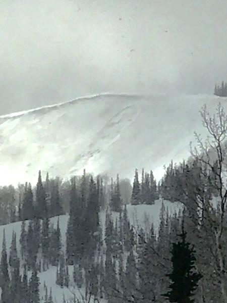
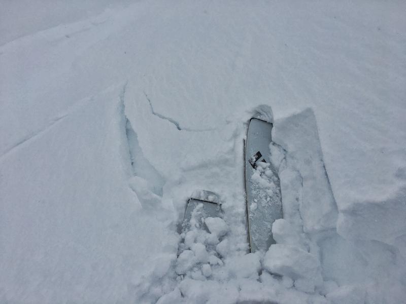
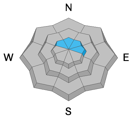
Today the avalanche danger is CONSIDERABLE at upper elevations where slabs of wind-drifted snow exist from various wind directions in the last three days. You'll have to be a detective to avoid these wind slabs because some will be covered by last night's new snow.
Isolated locations and pockets with a thin snowpack could have avalanches that break near the ground but these places will likely need the load of wind drifted snow.
The danger is MODERATE at mid and low elevations. Go to wind-sheltered slopes from any wind direction for the best skiing and riding where the main issue will be sluffing of the new snow in steep terrain.
Low
Moderate
Considerable
High
Extreme
Learn how to read the forecast here
Special Announcements
UDOT Backcountry Closure - From 7:30 a.m. this morning until 4 p.m.
Area closed is the north side of Little Cottonwood Canyon in the mid-canyon. See a map of the closure area HERE.
Snowbird Ski Patrol will be firing upon the Gad Valley/White Pine ridge this morning from 8am until 9:30am. Please stay well clear of the ridge line.
Weather and Snow
Since yesterday afternoon 7-13 inches of very light snow fell (0.3-0.6 inches of water). More snow is falling this morning but mostly in the middle sections of the Cottonwood Canyons.
Winds were blowing from the west yesterday 20-60 mph. This morning winds shifted to the NW and are blowing 10-15 mph with some gusts of 20 mph.
Temperatures are in the low single digits F.
Today will have mostly cloudy skies though the sun may appear and make some dramatic lighting. Temperatures should remain in the single digits F and begin falling tonight under clear skies. Winds will continue from the NW at 10-20 mph and could swing around and blow a little easterly.
Recent Avalanches
Yesterday at least one ski area reported sensitive slabs of wind drifted snow breaking 6-12 inches deep. Another ski area reported westerly winds stripping snow but not forming slabs. Previous wind slab activity occurred on Saturday following East and Northeast winds. See all the reported avalanches HERE.
Read this great observation about a wind slab avalanche and the challenges with identifying and managing them.
Overnight during periods of intense snowfall, some natural, dry loose slides occurred in the new snow.
One slide was spotted in South Monitor Bowl that broke near the ground. This avalanche occurred in a spot that has avalanched several times this season, a repeater. (Photo: J. Climaco)
Ad
Avalanche Problem #1
Wind Drifted Snow
Type
Location
Likelihood
Size
Description
Slabs of wind drifted snow were cracking and showing obvious signs of instability yesterday afternoon. These wind slabs should be easy to trigger this morning. They may start stabilizing through the day and become more stubborn but I wouldn't trust them today.
This avalanche problem will be tricky to avoid today because winds have blown in different directions loading different aspects. Also, new snow has covered some wind slabs that formed over the last few days. A few specific reasons:
  1. Even though winds calmed since yesterday, northerly winds this morning will have no trouble transporting the very light new snow and may even blow a little from the northeast today.
  2. Wind slabs formed by yesterday's strong westerly winds will (in some places) be covered by fresh snow and not look like places with wind drifted snow.
  3. East and Northeast winds early Friday morning formed wind slabs that will be hard to spot. These older wind slabs may still break today and produce a deeper avalanche as much as 2 feet deep.
  4. Some of these old wind slabs will be fairly dense and stiff which means they may not break until you get further onto them.
Evelyn was on Reynolds Peak and I was in Grizzly Gulch yesterday where we both found wind slabs that would crack - a sign on instability.
Avalanche Problem #2
New Snow
Type
Location
Likelihood
Size
Description
With up to 13 inches of new snow in some places like upper Little Cottonwood Canyon, the new snow should sluff easily in steep terrain today. I don't think the new snow will break as a slab because this storm was "right side up" meaning it got colder as the storm progressed and the snow became lighter.
Avalanche Problem #3
Persistent Weak Layer
Type
Location
Likelihood
Size
Description
We can't forget about a buried persistent weak layer near the ground on northerly and east aspects. In many places the snowpack has gotten over a meter deep and this layer has not been breaking in stability tests. However, it is weaker places with thin snow (less than 3 feet deep). The natural avalanche yesterday in South Monitor Bowl is a good reminder and good indication of the size of this type of avalanche.
To get a slab avalanche breaking on this layer, it probably needs a combination of a thin snowpack with a load of wind drifted snow.
General Announcements
This information does not apply to developed ski areas or highways where avalanche control is normally done. This forecast is from the U.S.D.A. Forest Service, which is solely responsible for its content. This forecast describes general avalanche conditions and local variations always occur.