Forecast for the Salt Lake Area Mountains

Drew Hardesty
Issued by Drew Hardesty on
Tuesday morning, December 18, 2018
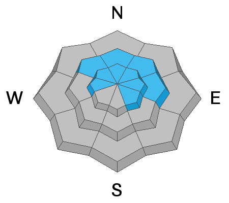
While most terrain has an overall LOW avalanche danger, isolated pockets of MODERATE DANGER exist for human triggered avalanches 2-4' deep into old snow layering. Heightened areas of concern include steep, thin, rocky terrain on northwest to easterly facing slopes. Collapsing and cracking may or may not be present to warn you of unstable avalanche conditions. Also avoid any smooth and rounded, stiff and stubborn hard wind slabs in steep terrain.
Low
Moderate
Considerable
High
Extreme
Learn how to read the forecast here
Special Announcements
The new UAC IOS mobile app is now available on the app store. Check out the new "My Weather" feature.

Check out the new free online avalanche course series developed by the Utah Avalanche Center. This is a great way to refresh your skills or prepare you for a Backcountry 101 or Level 1 class.
Weather and Snow
Skies are partly-becoming-mostly cloudy with temps in the mid-20s. Yesterday's strong southwest winds died overnight and are now light from the west. Not to worry, they'll reignite overnight with another weak storm system moving through. Our lone observation came from avalanche educator and guide Weston Deutschlander who pulled no punches in describing the conditions in the backcountry, "Like skiing on the moon only dealing with full gravity. Felt like I should have paid mother nature for the exfoliation session that lasted all day." Well said, Weston, well said. And he has a photo - beautiful, actually - to prove it.

We'll see a trace to two overnight into tomorrow. Winds will again be the spoiler, with the west-northwesterlies expected to increase to 35-40mph along the ridgelines. Clearing for later Wednesday into Thursday with another weak system on Friday. I know that the holidays are upon us but it's never too late to try to be good. Storms may arrive around Christmas.
Recent Avalanches
No reports of activity from the backcountry yesterday. In looking back at the avalanche observations, the last explosive triggered avalanches into the old October snow was in upper LCC on the 14th. The last human triggered slide into this layering was in Main Porter Fork (an avalanche accident) on the 8th.
Ad
Avalanche Problem #1
Persistent Weak Layer
Type
Location
Likelihood
Size
Description
Human triggered slides into this old snow layering is becoming increasingly difficult. Still, as the observation in Argenta (north side of Kessler Peak) in BCC suggests, not impossible. If not for the slope angle and the terrain features, this slope would have avalanched. Argenta often harbors shallow, weaker snow and we - as avalanche forecasters - often seek out the outliers for testing. In 2010, Birkeland, Simenhois, and Heierli presented a great study, THE EFFECT OF CHANGING SLOPE ANGLE ON EXTENDED COLUMN TEST RESULTS: CAN WE DIG PITS IN SAFER LOCATIONS? In a nutshell, they found that we don't necessarily need to "hang it out there" and dig pits in steep terrain for it to be representative of the slope. Aspect and elevation are enough. This was great confirmation that we can assume less risk in order to gather the info we want. On a side note, I know of at least two people who - when performing tests in a snowpit - triggered and were caught and carried in an avalanche. They ended up being ok, but I am still wondering how to score those test results. (cartoon from Mike Clelland of the Allen and Mike's book series - check them out)
General Announcements
This information does not apply to developed ski areas or highways where avalanche control is normally done. This forecast is from the U.S.D.A. Forest Service, which is solely responsible for its content. This forecast describes general avalanche conditions and local variations always occur.