Join us at our 2nd Annual Blizzard Ball

Forecast for the Salt Lake Area Mountains

Drew Hardesty
Issued by Drew Hardesty on
Thursday morning, January 23, 2025
Pockets of MODERATE avalanche danger exist around the compass at the mid and upper elevations. It's still possible to trigger a stiff and stubborn hard slab of wind drifted snow 1-2 foot deep and perhaps 100 feet wide. On west to north to east facing aspects at the mid and upper elevations, there is still an off-chance of triggering a hard slab that steps into an old persistent weak layer buried 2-4' deep. Caution is still advised.
Low
Moderate
Considerable
High
Extreme
Learn how to read the forecast here
Special Announcements
Urgent battery replacement required for anyone who received batteries from one of our participating "Batteries for Beacons" shops. Please review the "Batteries for Beacons" replacement notice on our blog. Batteries distributed through our "Batteries for Beacons" program this year have shown to be inadequate length.

Join the UAC at Deer Valley on January 30th for the 2nd Annual Blizzard Ball Gala. Former Director of the Utah Avalanche Center, Bruce Tremper will deliver the keynote address.
Weather and Snow
Skies are clear.
Temperatures straddle 0°F. Winds are 10-15mph from the north and nearly double that along the 11,000' level.
For today, we'll have sunny skies, light to moderate winds from the northwest and temps slowly warming into the upper teens.
They say that there are hundreds of words that describe snow, but after the recent bout of strong winds, I'd say that there are only a few left suitable for polite audiences.

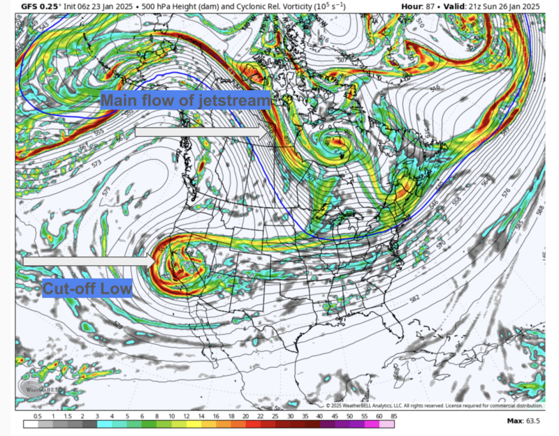
The Outlook: A storm out of the northwest splits, with a cut-off Low pressure system retrograding back to the southwest. Beyond that, who among us can forecast a wobbly cut-off Low?
If forced to guess, I'd say we might pick up a couple measly inches of new snow over the weekend with perhaps the Park City mountains and the Wasatch back receiving the lion's share.
Recent Avalanches
Avalanche control work in upper LCC yesterday produced a 2 foot deep and 125 foot wide avalanche in a heavily wind loaded northeast facing starting zone. Ski guides noted some fresh natural wind slabs in upper Cardiac Bowl as well.
Ad
Avalanche Problem #1
Wind Drifted Snow
Type
Location
Likelihood
Size
Description
Mark White's video of the relentless blowing and drifting of snow tells the tale. The backcountry is now littered with stiff and stubborn hard slabs of wind drifted snow. They'll be found all around the compass, but more commonly on aspects with an easterly component. They'll be found well off the ridgeline and eddied around unusual features. Remember, with hard slabs, you're "on top" of the pillow. With soft slabs, you're "in" the pillow. Hard slabs have a nasty habit of fracturing well after you're on to the slope. It may be another day or so before these rounded whales settle out and stabilize.
Avalanche Problem #2
Persistent Weak Layer
Type
Location
Likelihood
Size
Description
The buried facets near the ground have been present since early season, with most avalanche activity on this layer starting around Christmas. The last known avalanche on this layer was skier-triggered in Upper Big Cottonwood on Thursday, January 16.
The cracking, collapsing, and whumpfing have subsided, and the lack of in-your-face weakness makes for a tricky problem. Many old-timers are still avoiding steep thin rocky terrain.
Most likely areas to trigger an avalanche 2'-4' deep and up to 100' wide: west to north to east facing terrain at the mid and upper elevations. Other considerations below:
  • Thin, rocky zones, gullies, and slopes that have previously avalanched and reloaded with storm or wind-drifted snow.
  • Any large cornice fall may be enough to trigger one of these avalanches.
  • A new wind slab avalanche may step down into the older PWL.
General Announcements
This information does not apply to developed ski areas or highways where avalanche control is normally done. This forecast is from the U.S.D.A. Forest Service, which is solely responsible for its content. This forecast describes general avalanche conditions and local variations always occur.