Join us at our 2nd Annual Blizzard Ball

Forecast for the Provo Area Mountains

Drew Hardesty
Issued by Drew Hardesty on
Thursday morning, January 16, 2025
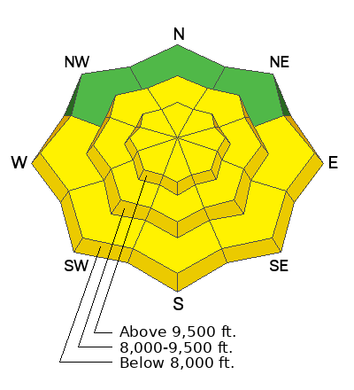
Areas of MODERATE avalanche danger exist in steep northwest to east facing terrain of the mid and upper elevations. You can still trigger a large and dangerous avalanche that fails 1-4 feet deep that fails on an old persistent weak layer of sugary facets. Caution is advised. The danger for wet avalanches will also rise to MODERATE on all steep sunlit slopes with daytime warming.
Low
Moderate
Considerable
High
Extreme
Learn how to read the forecast here
Special Announcements
Join the UAC at Deer Valley on January 30th for the 2nd Annual Blizzard Ball Gala. The night will be full of fun including delicious cuisine, live music, an auction, and presentation by Bruce Tremper.
Weather and Snow
Skies are clear with light winds from the southwest. Temps are in the low to mid-30s. For today, we'll have a carbon copy of yesterday with sunny skies, light wind and temps warming to the upper 30s. We do have a quick hitting storm on tap for Friday night into Saturday that should produce a trace to 2" but dramatically drop temps into the low single digits. No storms in sight beyond that.
Travel and riding conditions are easy and excellent although coverage is a bit thin. I toured around the north side of Timp yesterday and my report is HERE>
Recent Avalanches
We heard of a fair bit of wet avalanche activity on the steep solar aspects along the Timp massif.
Ad
Avalanche Problem #1
Persistent Weak Layer
Type
Location
Likelihood
Size
Description
The structure is poor but improving. A buried layer of faceted snow is buried 1-4 feet deep and the last avalanche triggered on this layering was on January 5th on the Wasatch Back. The problem is that these persistent weak layers are persistent and it still remains possible to trigger one of these avalanches in steep rocky thin terrain. These are still being triggered every day in the Salt lake region.
Avalanche Problem #2
Wet Snow
Type
Location
Likelihood
Size
Description
With morning temps already in the low to mid-30s, it will not take long for the snow on the steep sunlit slopes to become wet and unstable. Both natural and human triggered wet loose avalanches are expected today. Fortunately, they are WAY WAY more predictable and manageable than avalanches involving a PWL. If the snow is starting to feel punchy or you're seeing rollerballs, choose low angle terrain or cooler aspects.
General Announcements
This information does not apply to developed ski areas or highways where avalanche control is normally done. This forecast is from the U.S.D.A. Forest Service, which is solely responsible for its content. This forecast describes general avalanche conditions and local variations always occur.