UDOT PLANNED AVALANCHE CLOSURES!!

Forecast for the Provo Area Mountains

Greg Gagne
Issued by Greg Gagne on
Friday morning, January 10, 2025
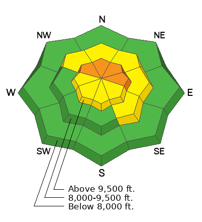
The avalanche danger is CONSIDERABLE on upper-elevation slopes and MODERATE on mid-elevation slopes facing northwest through east where there is a buried persistent weak layer. Avalanches may be 2-4 feet deep and over a hundred feet wide.
Upper-elevation slopes facing west through southeast (and some isolated mid-elevation, southeast-facing slopes) have a MODERATE avalanche danger.
Sensitive slabs of wind-drifted snow may be found on all aspects at the upper elevations and some exposed slopes at the mid-elevations.
Low
Moderate
Considerable
High
Extreme
Learn how to read the forecast here
Special Announcements
Receive forecast region-specific text message alerts to receive messages about changing avalanche conditions, watches, and warnings. Sign up and update your preferences HERE.
Weather and Snow
This Morning: Temperatures are 10-15° F and winds are from the northwest, with 10,000' winds averaging in the teens with gusts in the 20's mph. Wind speeds along the highest ridges and summits are averaging in the 20's with gusts in the upper 30's mph. Despite wind and cold temperatures over the past two days, many southerly slopes now have a thin sun crust.
Today: Mostly sunny skies with increasing clouds this afternoon and temperatures ranging through the 20's F. Winds will be from the northwest and gradually increasing through the day, with 10,000' winds gusting in the upper 20's mph and 11,000' winds gusting into the 40's mph.
This Weekend: Snow will begin this evening with snowfall and strong winds overnight and into Saturday morning. Snow showers may linger into Saturday, with possible snowfall totals of 6".
Recent Avalanches
No avalanches were reported from the backcountry on Thursday.
Check recent observations and avalanche reports to get a better understanding of current conditions across the Southern Wasatch.
Ad
Avalanche Problem #1
Persistent Weak Layer
Type
Location
Likelihood
Size
Description
The persistent weak layer (PWL) slowly continues to gain strength and it is getting more difficult to trigger avalanches. The most reported recent avalanche failing on the PWL was on Sunday in the Ant Knolls, and on Tuesday, Nikki Champion and Mack Talty from the UAC explored this region and continued to find a poor snow structure. You can read their excellent field report.
The type of terrain you are more likely to trigger an avalanche failing on the PWL is thinner snowpack areas such as:
- mid-elevations (particularly between 8,000 - 9,000') where there is simply less snow;
- steep, rocky areas;
- slopes that have already avalanched (aka "repeater" slopes) and have partially filled in.
If you trigger an avalanche in one of these thinner snowpack areas, it could propagate widely and up to 4 feet deep.
Trend: With more wind and snow forecast, increasing danger.
Avalanche Problem #2
Wind Drifted Snow
Type
Location
Likelihood
Size
Description
Recent winds from the northeast/east and today's increasing winds out of the northwest will create soft and hard slabs of wind-drifted snow. Some of these drifts may be sensitive if they form on top of sun crusts or weak snow at the surface. On mid and upper-elevation slopes facing northwest, north, or east, any avalanches involving fresh wind drifts may step down to the buried PWL.
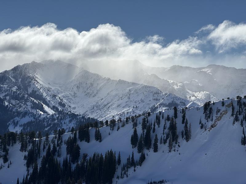
Thursday's northeast/east winds (photo: Mark Johnston)
Additional Information
The accident reports for the Porter Fork and Davenport Hill Accident have been completed. You can read them HERE.
At the Utah Avalanche Center, we strive to learn from every avalanche incident and share insights to help others avoid similar accidents. We have all experienced close calls and understand how easily mistakes can happen. Our goal with these reports is to provide valuable learning opportunities.
General Announcements
This information does not apply to developed ski areas or highways where avalanche control is normally done. This forecast is from the U.S.D.A. Forest Service, which is solely responsible for its content. This forecast describes general avalanche conditions and local variations always occur.