Sign Up for the Utah Snow and Avalanche Workshop (USAW) on December 7th!

Forecast for the Ogden Area Mountains

Drew Hardesty
Issued by Drew Hardesty on
Monday morning, March 11, 2024
Most terrain has LOW avalanche danger.
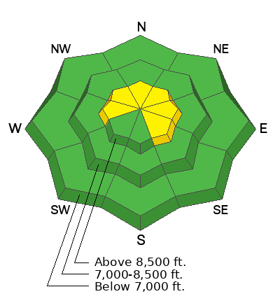
Areas of MODERATE, however, exist for pockety hard slabs of wind drifted snow, found primarily in the upper elevations.
Continue to avoid the overhanging cornices adorning the ridgelines.
Low
Moderate
Considerable
High
Extreme
Learn how to read the forecast here
Weather and Snow
Skies are mostly cloudy.
Winds are from the southwest, blowing 25-30mph with gusts to 35.* Mountain temperatures are in the mid to upper 30s. A weak going-through-the-motions "storm" will cast off a snowflake or two today. Winds should lose steam by the afternoon hours; temps will be in the 20s.
All eyes are on what I'm calling a Good News and Bad News Tuesday/Wednesday/Thursday storm. The GOOD news: A slow moving Pacific storm will bring cooler temps and perhaps 8-12" of snow to the mountains. The BAD news: strong east to northeast winds follow for Wednesday night to Thursday night and we finally wriggle free of the grasp of this nuisance of a weather system by Friday. With this much wind (particularly from the east), it's probably not even worth the trouble.
(*In last Tuesday's forecast, I said One more day of wind, people. I did not mean for the rest of the season.).

Backcountry conditions: Travel is easy but snow conditions are a bit tired and worn. It's still possible to find some soft snow that's not sun or wind damaged, but you'll have to be sneaky. Still, coverage is excellent with 6-10' of snow on the ground in the mountains with 4-6' at the trailheads. Be aware that lower elevation snow may be punchy and unsupportable after a poor overnight refreeze.
Recent Avalanches
Ski areas reported no avalanche activity, but a ski party reported triggering shallow pockets of wind drifted snow well off the ridgeline along the Cutler Ridge at 7200' and 7500'. These were but 4" deep but 30' wide.
Ad
Avalanche Problem #1
Wind Drifted Snow
Type
Location
Likelihood
Size
Description
Pockety hard slabs of wind drifted snow can still be triggered on a variety of aspects, even (perhaps especially) well off the ridgelines. Most of these will fall in the "upper" elevation bands, but a few may be found in the mid elevation bands. Hard slabs are often very smooth and rounded and have a nasty habit of releasing above you. It may be that you trigger them when you're off the fat, pillowy part of the slab and now onto the thinner, tapered part of the teardrop. Remember that with soft slabs, you're "in" the slab; with hard slabs, you're "on" the slab. Extra caution is required.
(Jim Conway graphics)
General Announcements
This information does not apply to developed ski areas or highways where avalanche control is normally done. This forecast is from the U.S.D.A. Forest Service, which is solely responsible for its content. This forecast describes general avalanche conditions and local variations always occur.