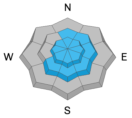
With yesterday's storm, there was more bark than bite. The mountains picked up about 3-8 inches in the past 24 hours (maybe a bit more in favored areas), a nice refresh to smooth out our previously rough surface. The winds stayed elevated so it's still possible to trigger an avalanche in wind-drifted terrain. These avalanches will likely be reserved for exposed upper and mid-elevation terrain and are likely pockety in nature. Continue to evaluate the snow and terrain carefully. Riding conditions, while not super deep, should be greatly improved and will remain that way for today into tomorrow while temperatures stay cool. You'll find the best conditions in upper-elevation, sheltered terrain on lower-angle slopes where you won't bump into the old surface crust.
The
Tony Grove Lake Snotel at 8400' reports a chilly 18°F this morning, and there is 103 inches of total snow at the site containing 121% of normal snow water equivalent. At the 9700'
CSI Logan Peak weather station, winds are blowing from the north-northwest in the teens mph with gusts in the 20's mph and it is 12°F. At our new
Paris Peak weather station at 9500', it's 11°F, and the wind is blowing from the west-northwest at 11 mph with gusts around 20 mph. It's 14°F at our new
Card Canyon weather station at 8800', and there is 86 inches of total snow.
Expect wintery conditions today in the mountains with continued light snowfall mainly in the afternoon. Moderate winds blowing from the west will make it feel un-April-like with wind chills in the teens °F. We are expected to only get a few more inches at the most. Sunshine returns tomorrow and high pressure builds in for the work week ahead.
For more information, visit our mountain weather page
HERE.
No avalanches were reported yesterday.
Check out all local observations and avalanches
HERE.


