Sign Up for the Utah Snow and Avalanche Workshop (USAW) on December 7th!

Forecast for the Logan Area Mountains

Toby Weed
Issued by Toby Weed on
Wednesday morning, March 13, 2024
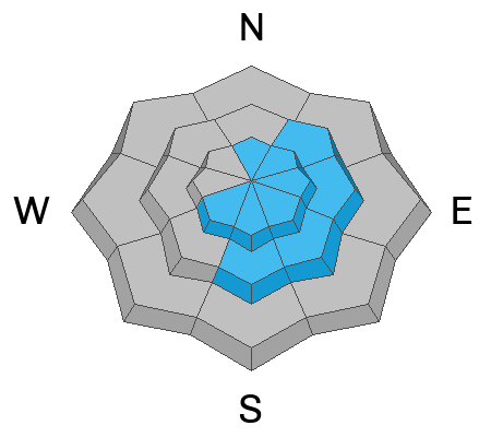
Overnight, several inches of new snow and drifting by winds from the northwest elevated the avalanche danger to MODERATE. Expect heightened avalanche conditions in drifted upper and mid-elevation terrain where people could trigger small soft slab avalanches of wind-drifted snow up to around a foot thick on slopes steeper than 30°. Long-running sluffs of new snow sliding on a slick melt-freeze crust are also possible.

Evaluate snow and terrain carefully, and pay close attention to potential terrain traps below; like trees, gullies, benches, sinks, or cliffs that even small avalanches might carry you into.
Low
Moderate
Considerable
High
Extreme
Learn how to read the forecast here
Special Announcements
Support the UAC website rebuild by donating to our spring campaign. Save lives by making a donation today!
The UAC is proud to present "To the Hills & Back", a heart-wrenching documentary that delves into the lives of two backcountry skiers, Katie Combaluzier and Adam Campbell, who navigate through the aftermath of separate avalanche tragedies. This film is a testament to human endurance and the transformative power of adversity. Watch it here.
Weather and Snow
A fresh coating of new snow will refresh the scenery and improve riding conditions in the backcountry. Last night, winds from the northwest picked up steam for several hours, drifting the fresh snow at upper and mid elevations onto lee slopes and into avalanche starting zones. Today, people could trigger small wind slab avalanches of drifted storm snow or long-running sluffs. Even small avalanches can be dangerous because they could carry you into trees or other terrain traps below steep slopes. Today, we'll find the best shallow powder and dust-on-crust conditions at upper elevations on lower-angled slopes and in sheltered terrain. Before yesterday's storm, the snow up high in northerly terrain was still soft, while it was more variable lower down, with inconsistent breakable crusts and more solid melt-freeze crusts on select sunny slopes.
The Tony Grove Lake Snotel at 8400' recorded 4 inches of new snow overnight and 6 inches in the last 24 hours, containing .8" SWE (snow water equivalent). There is 113" of total snow with 128% of normal SWE for the date. Temperatures cooled a bit overnight, and it's 22° F this morning. At our new Card Canyon weather station (8750'), the temperature is 18 °F, with around 3" of new snow and a total snow depth of 86 inches. Meanwhile, at the CSI Logan Peak weather station (9700'), it's 16°F, with winds blowing from the north-northwest at 20 mph with gusts up to 41 mph overnight. On Paris Peak (at 9500'), it's 15°F, with winds blowing from the northwest at 11 mph and overnight gusts up to 26 mph.
Today, we can expect mostly cloudy skies with 8500' high temperatures around 23° F and winds from the north-northwest blowing around 15 mph.
Tomorrow will be mostly sunny with a high temperature around 30° F. The big news is an easterly wind event. East winds are expected to increase significantly tomorrow, blowing 26 to 31 mph with gusts around 45 mph in the afternoon.
East winds will continue tomorrow night and diminish a bit on Friday, with sunny skies and a high temperature at 8500' around 32° F. Expect fair weather with warming daytime temperatures and plenty of sun through the weekend.
Recent Avalanches
There were no new reports of avalanches in the Logan area backcountry yesterday.
On Friday, a rider was caught, carried, and mostly buried just northeast of Midnight Mountain. The avalanche failed as a hard slab of wind-drifted snow around 3 feet deep and 175 feet wide. Chad and Michael Davis were able to make their way up there Saturday. (See Video Below). Find the full observation HERE.

Check out all local observations and avalanches HERE.
Ad
Avalanche Problem #1
Wind Drifted Snow
Type
Location
Likelihood
Size
Description
Expect to find fresh soft slabs of wind-drifted snow at upper and mid-elevations. These wind slabs will be generally shallow but could be sensitive to the weight of a rider today, given they formed on top of a wide variety of supportable crusts and snow surfaces.
  • Watch for and avoid stiffer drifted snow on the lee side of prominent ridges, below cornices, and in and around terrain features like gullies, cliff bands, mid-slope rollovers, and sub-ridges.
  • Cornices present a real danger today as well. Give them a wide berth because they can break further back than expected. Cornice falls could trigger avalanches on slopes below.
  • In more sheltered terrain, shallow soft slabs and loose sluffs of new snow are possible. Some of these could run fast and far on a smooth melt-freeze crust.
  • Watch for potential terrain traps like trees, gullies, benches, sinks, or cliffs below that even a small avalanche might carry you into.
Additional Information
General Announcements
-National Forest Winter Recreation Travel Maps show where it's open to ride: UWCNF Logan, Ogden LRD Tony Grove, Franklin Basin CTNF Montpelier
-Listen to your very own Logan Zone avalanche forecasters on the UAC Podcast HERE.
-Read Toby's blog about wind, drifting, and avalanches HERE.
-Sign up for forecast region-specific text message alerts. You will receive messages about changing avalanche conditions, watches, and warnings...HERE.
-For all questions on forecasts, education, Know Before You Go, events, online purchases, or fundraising, call 801-365-5522.
-To report an avalanche or submit an observation from the backcountry, go HERE.
-Come practice companion rescue at the Franklin Basin TH Beacon Training Park. It's free and open to everyone. For easy user instructions, go HERE.
-Trent will update this forecast by 7:30 AM tomorrow.
This forecast is from the U.S.D.A. Forest Service, which is solely responsible for its content. This forecast describes general avalanche conditions, and local variations always occur.