Forecast for the Logan Area Mountains

Toby Weed
Issued by Toby Weed on
Tuesday morning, February 11, 2025
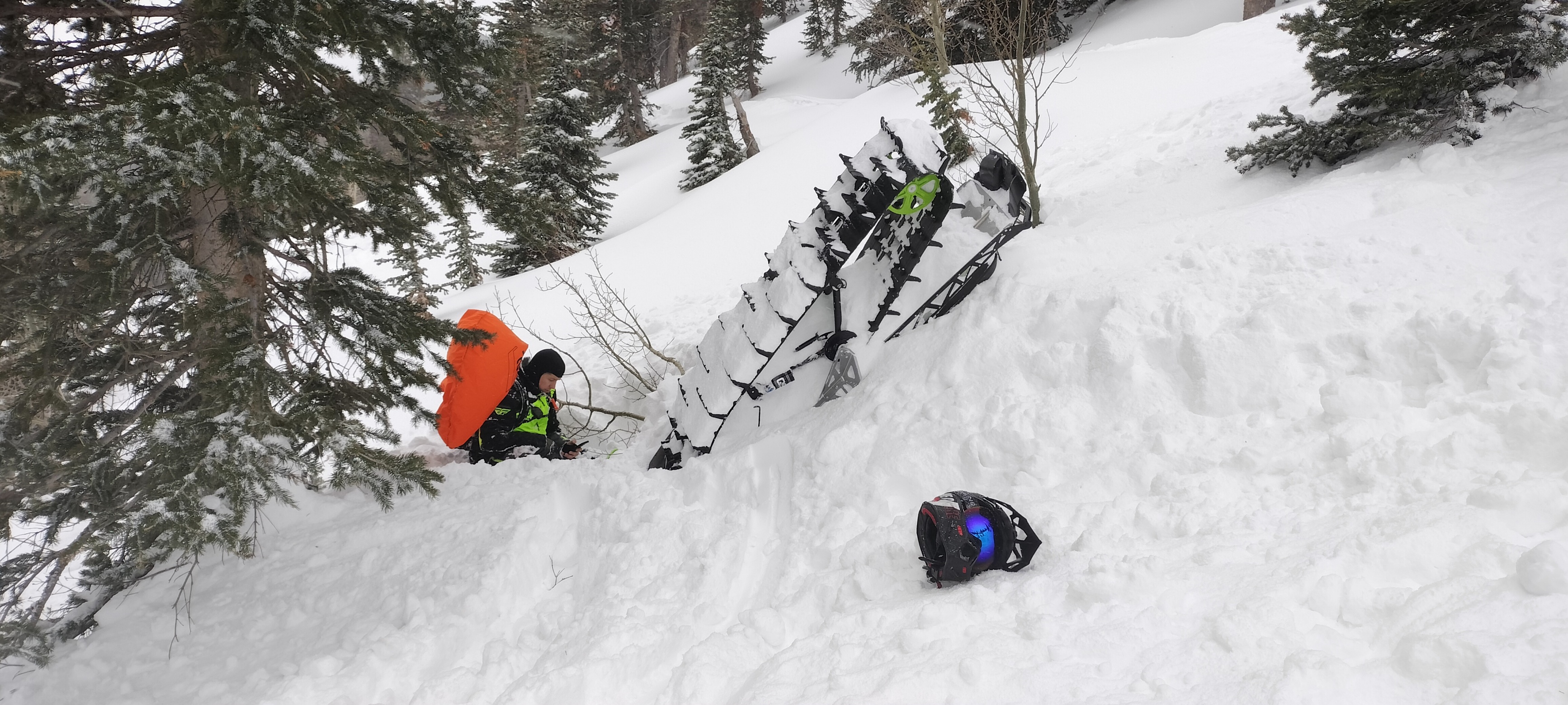
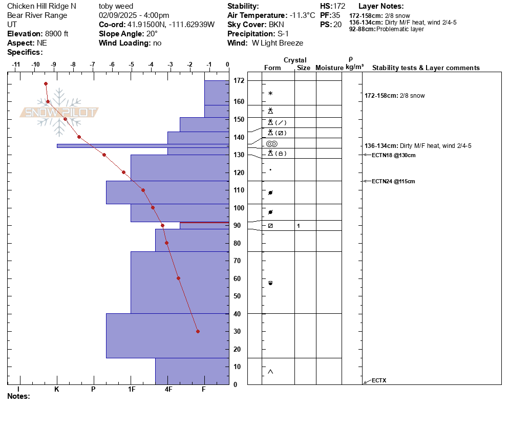
Heightened avalanche conditions exist and the danger is MODERATE in upper and mid-elevation terrain steeper than 30°. People could trigger dangerous slab avalanches on previously drifted slopes where a persistent weak layer is buried 1 to 3 feet deep. You can find fine, fast powder conditions in the meadows and on lower angled slopes.
  • Evaluate the snow and terrain carefully. You will need to take out your shovel and dig to find and asses the buried persistent weak layer.
  • Continue to avoid being on or under steep drifted slopes and ridge-top cornices.
Low
Moderate
Considerable
High
Extreme
Learn how to read the forecast here
Special Announcements
The final accident report for last week's fatal Monte Cristo avalanche is HERE.
Weather and Snow
You'll find excellent shallow powder riding conditions across the zone with right-side-up snow capping a thick and very solid melt-freeze crust from last week's unseasonable warmth. The biggest concern for today is triggering an avalanche that fails on a buried persistent weak layer lurking below the crust. Areas of wind-drifted snow from the weekend storm are particularly suspect, especially in upper-elevation terrain on slopes facing northwest through southeast. While the problem appears to be pockety in nature, the easiest way to avoid it is to stick to slopes less than 30°. Just last Friday, a rider was fully buried by a large avalanche that failed on a buried persistent weak layer, so there are probably other suspect slopes out there just waiting for a trigger. Avalanches stepping down into the faceted weak layer are more likely where last week's crust is thinner or non-existent. I'm especially leery of slopes in outlying terrain with generally shallow and weak snow cover.

-The Tony Grove Snotel at 8400 feet reports 8° F, with 71 inches of total snow. At our Card Canyon weather station at 8800 feet, it's 4° F, and there is 51 inches of total snow.
-At the CSI Logan Peak weather station at 9700 feet, winds are blowing from the west-southwest 16 to 21 mph, it's 3° F, and the wind chill is -16° F. On Paris Peak, at 9500 feet, it is -2° F, and the winds are blowing from the west 10 to 13 mph creating a -20° F wind chill value.

It's going to be a cold, cloudy day in the mountains, with some snow possible. The high temperature will be 13° F at 8500', winds will blow from the west-northwest at 6 to 10 mph and the wind chill value will be as low as -11° F. Temperatures will continue to plummet through Thursday morning when our next significant storm starts to move into the zone. 10 to 18 inches of accumulation is possible in favored Bear River Range locations Thursday night and Friday.

For more information, visit the UAC weather page here: Weather - Utah Avalanche Center
For Logan-specific weather, go here: Logan Mountain Weather - Utah Avalanche Center
Recent Avalanches
  • Observers spied several recent natural avalanches in the Wellsville Range from across Cache Valley yesterday, including a large hard slab in Hell Canyon.
  • A rider was caught, carried, and buried in the Franklin Basin Area on Friday. The buried rider, with only a hand and a bit of their deployed airbag sticking out of the snow, was found and rescued by a companion. Report is HERE.
  • Observers reported numerous red flags of instability last week, including long shooting cracks and extensive whumpfs.
    Read about all avalanches and observations in the Logan Zone HERE.
***Remember, the information you share about avalanches you see or trigger in the backcountry could save lives.
Ad
Avalanche Problem #1
Persistent Weak Layer
Type
Location
Likelihood
Size
Description
In late January, the Logan area mountains developed a widespread layer of weak and sugary surface snow. Wind drifting and recent accumulations built thick slabs on top of this layer and now, many slopes are plagued by a persistent weak layer buried 1 to 3 feet deep. Today, people could trigger dangerous hard slab avalanches failing on this persistent weak layer in upper-elevation terrain.
  • Avalanches failing on a buried persistent weak layer might be triggered remotely (from a distance) or from below.
  • Audible collapses (whumpfs) and shooting cracks are sure signs of instability, but these may not be present when avalanches occur.
  • The best way to avoid this problem is to avoid steep slopes with poor snowpack structure. (You will have to dig to find and asses buried persistent weak layers)
  • Excellent powder riding can be found in the meadows and on slopes less steep than 30°.
Avalanche Problem #2
Wind Drifted Snow
Type
Location
Likelihood
Size
Description
We advise staying clear of steep, previously wind-drifted slopes. Today, human-triggered hard wind slab avalanches failing on a buried persistent weak layer are possible.
  • Wind slabs are most likely to be found on the lee side of major ridges and corniced slopes facing northwest through southeast. They were also formed by cross-loading in and around terrain features like sub-ridges, gullies, and cliff bands.
  • Hard wind slabs sometimes allow a person to get well out on them before suddenly releasing.
Additional Information

In the snowpit profile below, you can see last week's solid m/f crust capping hard drifted snow that blew in on the sugary persistent weak layer that was on the surface in late January.
General Announcements
-National Forest Winter Recreation Travel Maps show where it's open to ride: UWCNF Logan, Ogden LRD Tony Grove, Franklin Basin CTNF Montpelier
-For all questions on forecasts, education, Know Before You Go, events, online purchases, or fundraising, call 801-365-5522.
-Remember the information you provide could save lives, especially if you see or trigger an avalanche. To report an avalanche or submit an observation from the backcountry, go HERE.
-Receive forecast region-specific text message alerts to receive messages about changing avalanche conditions, watches, and warnings. Sign up and update your preferences HERE.

This forecast is from the U.S.D.A. Forest Service, which is solely responsible for its content. This forecast describes general avalanche conditions, and local variations always occur.